TopoQuest Logo
Do you find TopoQuest useful?
Help keep TopoQuest running and adding new maps/features by donating!
Bitcoin:  19c7KJd3qBynnjoSw5npx9KScwjBe4ifkT
Litecoin:  LXs6TkuXGGXo1vDsWCkWVdjQX94eUKd6ui
Home View Maps Find Maps Find Places Resources & Links


Eureka, Alabama Topographic Map

USGS Map Title: Eureka, AL
USGS Map MRC: 34085H8
DRG (GeoTIFF) Download: o34085h8.tif


Neighboring USGS Topographic Map Quads:


  Pitcher Ridge, TN  
35086A1
 

  Sinking Cove, TN  
35085A8
 

  Orme, TN  
35085A7
 

  Hytop, AL  
34086H1
 

  Eureka, AL  
34085H8
 

  Doran Cove, AL  
34085H7
 

  Mud Creek, AL  
34086G1
 

  Wannville, AL  
34085G8
 

  Stevenson, AL  
34085G7


Map MRC Location:

N35°
W86°
N35°
W85°
H8 H7 H6 H5 H4 H3 H2 H1
G8 G7 G6 G5 G4 G3 G2 G1
F8 F7 F6 F5 F4 F3 F2 F1
E8 E7 E6 E5 E4 E3 E2 E1
D8 D7 D6 D5 D4 D3 D2 D1
C8 C7 C6 C5 C4 C3 C2 C1
B8 B7 B6 B5 B4 B3 B2 B1
A8 A7 A6 A5 A4 A3 A2 A1
N34°
W86°
N34°
W85°

Eureka, AL USGS 1:24K Topographic Map Preview:
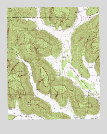
Eureka, AL USGS Topographic Map
Click on map above to begin viewing in our Map Viewer.

This topographic map contains these locations and features:
Feature Name Type Latitude Longitude GNIS ID View Map
Alabama School (historical)SchoolN34.9731°W85.9264°139087View Map
Allen CemeteryCemeteryN34.8798°W85.9633°113002View Map
AllisonPopulated PlaceN34.8779°W85.9594°155988View Map
Allison CemeteryCemeteryN34.8848°W85.9833°113034View Map
Allison Mill (historical)LocaleN34.8792°W85.9633°1700324View Map
AndersonPopulated PlaceN34.9940°W85.9030°1314583View Map
Anderson QuarryMineN34.9928°W85.9042°2633336View Map
Armstrong CemeteryCemeteryN34.8867°W85.9983°113223View Map
Arnold GapGapN34.9062°W85.9166°113234View Map
BassPopulated PlaceN34.9320°W85.9130°156032View Map
Bass HollowValleyN34.9738°W85.9284°113554View Map
Bass Station (historical)LocaleN34.9298°W85.9100°139091View Map
Bell SpringSpringN34.8874°W85.9959°113869View Map
Bell StoreLocaleN34.8879°W85.9925°113870View Map
Bennett CoveValleyN34.9331°W85.9308°113923View Map
Betsy GapGapN34.9859°W85.9947°114163View Map
Blue SpringSpringN34.9467°W85.9178°139104View Map
Boston HollowValleyN34.9262°W85.9719°114751View Map
Brisco StoreLocaleN34.9231°W85.9016°114924View Map
Carr CemeteryCemeteryN34.8870°W85.8872°149557View Map
Cave BranchStreamN34.8795°W85.9869°115715View Map
Cave SpringPopulated PlaceN34.9081°W85.9605°156155View Map
Cave SpringSpringN34.9081°W85.9596°149283View Map
Cave Spring ChurchChurchN34.9084°W85.9603°139128View Map
Cave Spring School (historical)SchoolN34.9090°W85.9605°139129View Map
Centennial ChurchChurchN34.9004°W85.8911°115829View Map
Champion CemeteryCemeteryN34.9548°W85.9930°115927View Map
Champion HollowValleyN34.9537°W85.9903°115929View Map
Champion School (historical)SchoolN34.9395°W85.9761°139133View Map
Champion SpringSpringN34.9536°W85.9923°115931View Map
Crow Creek Valley Volunteer Fire Department Station 2BuildingN34.9950°W85.8960°2654876View Map
Culver HollowValleyN34.8959°W85.9883°116954View Map
Cumberland CemeteryCemeteryN34.9792°W85.9439°116956View Map
Daniel GapGapN34.9381°W85.9611°117050View Map
Dry CoveValleyN34.9234°W85.8878°117526View Map
Elliott HollowValleyN34.9404°W85.9822°117943View Map
EurekaPopulated PlaceN34.9001°W85.8836°156323View Map
Gibson CoveValleyN34.8876°W85.9214°118927View Map
GoncePopulated PlaceN34.9873°W85.9544°156415View Map
Gonce CemeteryCemeteryN34.9965°W85.8953°1318408View Map
Gonce ChurchChurchN34.9868°W85.9536°149569View Map
Gounce ChurchChurchN34.9965°W85.8947°1285757View Map
Gourdneck HollowValleyN34.9873°W85.8935°119191View Map
Gum SpringSpringN34.8816°W85.9793°119483View Map
Helton CemeteryCemeteryN34.8887°W85.9150°119942View Map
Helton Memorial ChurchChurchN34.8790°W85.8950°119943View Map
Hicks CoveValleyN34.9434°W85.9850°120040View Map
High PointCliffN34.9284°W85.9850°120060View Map
Holly Flat CreekStreamN34.9945°W85.9022°1650987View Map
Ike HollowValleyN34.9159°W85.9625°120619View Map
Jacoway BranchStreamN34.9220°W85.9208°120797View Map
Jacoway CemeteryCemeteryN34.9323°W85.8847°120798View Map
Jacoway HollowValleyN34.9350°W85.8846°120799View Map
John Sumach ReservationParkN34.9793°W85.9383°120918View Map
Kellum HollowValleyN34.8859°W85.9886°121114View Map
Kirby Creek (historical)Populated PlaceN34.8993°W85.9533°139203View Map
Knight GapGapN34.8943°W85.9744°121272View Map
Lead HollowValleyN34.9017°W85.9486°121445View Map
Little Coon ValleyValleyN34.8762°W85.9099°121742View Map
Little Crow CreekStreamN34.9547°W85.9158°1291465View Map
Little MountainSummitN34.9384°W85.9044°121823View Map
Longacre CemeteryCemeteryN34.8757°W85.8824°122018View Map
Looney GapGapN34.9759°W85.9772°122026View Map
Matthews CemeteryCemeteryN34.9017°W85.9628°122392View Map
Matthews CemeteryCemeteryN34.9256°W85.9719°122393View Map
Matthews ChurchChurchN34.9434°W85.9219°149578View Map
McCrary CemeteryCemeteryN34.9390°W85.9750°122500View Map
New Hope ChurchChurchN34.8804°W85.9730°123843View Map
Pleasant GrovePopulated PlaceN34.9437°W85.9216°156909View Map
Pleasant Grove CemeteryCemeteryN34.9776°W85.9133°124941View Map
Pleasant Grove School (historical)SchoolN34.9423°W85.9214°139250View Map
Poplar SpringSpringN34.9845°W85.9959°125158View Map
Rash School (historical)SchoolN34.8787°W85.8958°1700338View Map
Round Cove CemeteryCemeteryN34.9987°W85.9925°1300153View Map
Round MountainSummitN34.9990°W85.9764°1300169View Map
Salt RiverStreamN34.9843°W85.9555°126269View Map
Salt River CoveValleyN34.9850°W85.9596°139274View Map
Sentill HollowValleyN34.8967°W85.9372°126551View Map
Shiny RockCapeN34.9859°W85.9205°126770View Map
Shirley HollowValleyN34.9579°W85.8941°126780View Map
Sikes CemeteryCemeteryN34.9381°W85.9416°149596View Map
Slipoff HollowValleyN34.8762°W85.9855°126975View Map
Sparkman MineMineN34.9590°W85.8847°139293View Map
Steele PointCliffN34.9579°W85.9419°127344View Map
Stevenson DivisionCivilN34.8858°W85.9288°165812View Map
Sumach HollowValleyN34.9799°W85.9393°127531View Map
Summers TopSummitN34.9512°W85.9716°127543View Map
Talley DitchCanalN34.9131°W85.8794°127652View Map
Tongue SpringSpringN34.9887°W85.9694°1304136View Map
Tongue SpringSpringN34.9887°W85.9700°153702View Map
Walnut Grove ChurchChurchN34.8909°W85.9930°139307View Map
Warren PeakSummitN34.9645°W85.9000°128586View Map
White House School (historical)SchoolN34.8804°W85.9719°139312View Map
Willis BranchStreamN34.9895°W85.8991°129046View Map
Willis CemeteryCemeteryN34.9856°W85.8861°129048View Map
Wynn Store (historical)LocaleN34.9062°W85.9572°139319View Map

Note: Coordinates in the location and feature list above are referenced to NAD83 datum.


Copyright (C) 2008-2025 Ryan Niemi / Sunset Dynamics ... All Rights Reserved