TopoQuest Logo
Do you find TopoQuest useful?
Help keep TopoQuest running and adding new maps/features by donating!
Bitcoin:  19c7KJd3qBynnjoSw5npx9KScwjBe4ifkT
Litecoin:  LXs6TkuXGGXo1vDsWCkWVdjQX94eUKd6ui
Home View Maps Find Maps Find Places Resources & Links


Wannville, Alabama Topographic Map

USGS Map Title: Wannville, AL
USGS Map MRC: 34085G8
DRG (GeoTIFF) Download: o34085g8.tif


Neighboring USGS Topographic Map Quads:


  Hytop, AL  
34086H1
 

  Eureka, AL  
34085H8
 

  Doran Cove, AL  
34085H7
 

  Mud Creek, AL  
34086G1
 

  Wannville, AL  
34085G8
 

  Stevenson, AL  
34085G7
 

  Scottsboro, AL  
34086F1
 

  Hollywood, AL  
34085F8
 

  Henagar, AL  
34085F7


Map MRC Location:

N35°
W86°
N35°
W85°
H8 H7 H6 H5 H4 H3 H2 H1
G8 G7 G6 G5 G4 G3 G2 G1
F8 F7 F6 F5 F4 F3 F2 F1
E8 E7 E6 E5 E4 E3 E2 E1
D8 D7 D6 D5 D4 D3 D2 D1
C8 C7 C6 C5 C4 C3 C2 C1
B8 B7 B6 B5 B4 B3 B2 B1
A8 A7 A6 A5 A4 A3 A2 A1
N34°
W86°
N34°
W85°

Wannville, AL USGS 1:24K Topographic Map Preview:
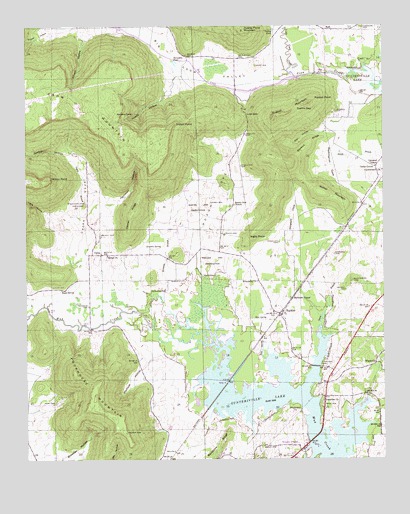
Wannville, AL USGS Topographic Map
Click on map above to begin viewing in our Map Viewer.

This topographic map contains these locations and features:
Feature Name Type Latitude Longitude GNIS ID View Map
Allison HollowValleyN34.8723°W85.9803°113036View Map
Baker CemeteryCemeteryN34.7537°W85.9166°113377View Map
Baker CemeteryCemeteryN34.7562°W85.9141°1700407View Map
Bethel ChurchChurchN34.8090°W85.9714°114085View Map
Big Coon CreekStreamN34.8606°W85.9058°114249View Map
Big Coon ValleyValleyN34.8606°W85.9058°114250View Map
Blue SpringSpringN34.7906°W85.9163°114577View Map
Blue SpringSpringN34.7695°W85.8975°1700408View Map
Blue Spring BrookStreamN34.7787°W85.9164°114583View Map
Brewster HollowValleyN34.7909°W86.0000°114874View Map
Bryant CemeteryCemeteryN34.7987°W85.8880°115084View Map
Bryant CemeteryCemeteryN34.8142°W85.9741°115085View Map
Cambell ChapelChurchN34.8345°W85.8775°115425View Map
Campbell ChapelChurchN34.8348°W85.8778°149556View Map
Carnes School (historical)SchoolN34.8095°W85.9716°1959035View Map
CarnsPopulated PlaceN34.8092°W85.9741°115633View Map
Carns CoveValleyN34.8020°W85.9747°115634View Map
Coffey CemeteryCemeteryN34.8154°W85.9119°149561View Map
Cross CemeteryCemeteryN34.8131°W85.9122°149563View Map
Dudley PondLakeN34.8739°W85.9132°117628View Map
Dudley Pond MountainSummitN34.8740°W85.9241°117630View Map
FacklerPopulated PlaceN34.7926°W85.9100°118100View Map
Fackler Volunteer Fire DepartmentBuildingN34.7915°W85.9114°2683204View Map
Fairfield (historical)Populated PlaceN34.7662°W85.9986°139159View Map
Friendship ChurchChurchN34.8012°W85.9191°151783View Map
Garner RidgeRidgeN34.8206°W85.9633°118841View Map
Goshen HollowValleyN34.8376°W85.9850°119186View Map
Hammon HollowValleyN34.8237°W85.9708°119654View Map
Happy HollowValleyN34.8629°W85.9475°119699View Map
Horseshoe PondLakeN34.8638°W85.9474°120434View Map
Houston BranchStreamN34.7923°W85.9594°120457View Map
Houston SpringSpringN34.8112°W85.9580°120466View Map
Hurt CemeteryCemeteryN34.7662°W85.9894°120600View Map
Indian PointCapeN34.8465°W85.9480°120668View Map
Inglis BranchStreamN34.8059°W85.9839°120684View Map
Inglis CemeteryCemeteryN34.8234°W85.9794°120685View Map
Inglis HollowValleyN34.8201°W85.9925°120686View Map
Inglis PointCapeN34.8151°W85.9208°120687View Map
Jackson CountyCivilN34.7794°W85.9993°161561View Map
Jacobs Mill (historical)LocaleN34.8104°W85.9403°139197View Map
Kyles CemeteryCemeteryN34.7992°W85.9908°121288View Map
Kyles SpringSpringN34.7988°W85.9877°121289View Map
Lakeview ChurchChurchN34.7667°W85.8961°121337View Map
Lewallen CemeteryCemeteryN34.8129°W85.9114°121511View Map
Little Coon CreekStreamN34.8604°W85.9055°121740View Map
Lovelady CemeteryCemeteryN34.7773°W85.8950°122061View Map
Lovelady CemeteryCemeteryN34.8440°W85.9230°122062View Map
Low GapGapN34.8492°W85.9228°122071View Map
Loyds CemeteryCemeteryN34.8309°W85.9416°149577View Map
Matthews ChapelChurchN34.7967°W85.9075°122394View Map
Middleton CemeteryCemeteryN34.8242°W85.9791°122699View Map
Middleton CemeteryCemeteryN34.8348°W85.9250°122700View Map
Mud Creek Boat DockLocaleN34.7556°W85.9014°141116View Map
Owen BranchStreamN34.7873°W85.8975°124340View Map
Owl HollowValleyN34.8465°W85.8939°124357View Map
Pauper CemeteryCemeteryN34.7576°W85.9653°124507View Map
Poorhouse MountainSummitN34.7681°W85.9758°125137View Map
Price CemeteryCemeteryN34.7659°W85.8964°125263View Map
RashPopulated PlaceN34.8740°W85.8950°156944View Map
Renshaw BridgeBridgeN34.7879°W85.9772°141117View Map
Renshaw CemeteryCemeteryN34.7945°W85.9783°125567View Map
Roach CemeteryCemeteryN34.8148°W85.9308°125677View Map
Roach CoveValleyN34.8098°W85.9408°125678View Map
Roach School (historical)SchoolN34.8226°W85.9275°139259View Map
Roaches Cove Baptist ChurchChurchN34.8234°W85.9272°153163View Map
Rorex CemeteryCemeteryN34.8242°W85.9355°125930View Map
Rosenwald School (historical)SchoolN34.8006°W85.9172°139264View Map
Russell CemeteryCemeteryN34.8506°W85.8914°126029View Map
Russell MountainSummitN34.8487°W85.9133°126037View Map
Russell PointCapeN34.8540°W85.8994°126038View Map
Russells School (historical)SchoolN34.8501°W85.8925°139267View Map
Russells TrackParkN34.8501°W85.8858°139268View Map
Saddle GapGapN34.8512°W85.9053°126073View Map
Samuel Key ReservationParkN34.8215°W85.9436°126288View Map
Schrader Mill (historical)LocaleN34.7840°W85.8858°139278View Map
Shipp CemeteryCemeteryN34.8634°W85.9194°126774View Map
Stewart RidgeRidgeN34.8415°W85.9008°127391View Map
Stogsdill CoveValleyN34.8126°W85.9089°127420View Map
Stogspill CemeteryCemeteryN34.8092°W85.8922°127423View Map
Walker MountainSummitN34.8270°W85.8964°128525View Map
WannvillePopulated PlaceN34.7776°W85.8778°157214View Map
Wanville ChurchChurchN34.7804°W85.8761°1959072View Map
Wanville School (historical)SchoolN34.7804°W85.8761°1959073View Map
Washington CemeteryCemeteryN34.8017°W85.8858°128610View Map
Washington CoveValleyN34.8373°W85.8908°128611View Map
William Key ReservationParkN34.8092°W85.9303°128996View Map
Wilson PointCapeN34.8312°W85.9922°129091View Map
Womack HollowValleyN34.7765°W85.9591°129181View Map
Womacks Store (historical)LocaleN34.8090°W85.9655°1700414View Map
Wrights ChapelChurchN34.7540°W85.9050°129249View Map

Note: Coordinates in the location and feature list above are referenced to NAD83 datum.


Copyright (C) 2008-2024 Ryan Niemi / Sunset Dynamics ... All Rights Reserved