TopoQuest Logo
Do you find TopoQuest useful?
Help keep TopoQuest running and adding new maps/features by donating!
Bitcoin:  19c7KJd3qBynnjoSw5npx9KScwjBe4ifkT
Litecoin:  LXs6TkuXGGXo1vDsWCkWVdjQX94eUKd6ui
Home View Maps Find Maps Find Places Resources & Links


Deserter Baygall, Texas Topographic Map

USGS Map Title: Deserter Baygall, TX
USGS Map MRC: 30094D2
DRG (GeoTIFF) Download: o30094d2.tif


Neighboring USGS Topographic Map Quads:


  Hicksbaugh, TX  
30094E3
 

  Fred, TX  
30094E2
 

  Potato Patch Lake, TX  
30094E1
 

  Kountze North, TX  
30094D3
 

  Deserter Baygall, TX  
30094D2
 

  Franklin Lake, TX  
30094D1
 

  Kountze South, TX  
30094C3
 

  Silsbee, TX  
30094C2
 

  Evadale, TX  
30094C1


Map MRC Location:

N31°
W95°
N31°
W94°
H8 H7 H6 H5 H4 H3 H2 H1
G8 G7 G6 G5 G4 G3 G2 G1
F8 F7 F6 F5 F4 F3 F2 F1
E8 E7 E6 E5 E4 E3 E2 E1
D8 D7 D6 D5 D4 D3 D2 D1
C8 C7 C6 C5 C4 C3 C2 C1
B8 B7 B6 B5 B4 B3 B2 B1
A8 A7 A6 A5 A4 A3 A2 A1
N30°
W95°
N30°
W94°

Deserter Baygall, TX USGS 1:24K Topographic Map Preview:
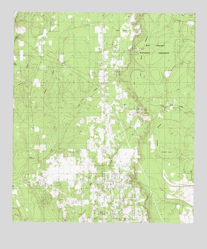
Deserter Baygall, TX USGS Topographic Map
Click on map above to begin viewing in our Map Viewer.

This topographic map contains these locations and features:
Feature Name Type Latitude Longitude GNIS ID View Map
All Faith TabernacleChurchN30.3802°W94.1677°1350986View Map
Beech Creek Oil FieldOilfieldN30.4902°W94.2435°1351782View Map
Caney HeadSummitN30.4994°W94.1674°1353745View Map
Deserter BaygallSwampN30.4335°W94.1527°1355940View Map
Deserter IslandIslandN30.4174°W94.1413°1355941View Map
FreseniusPopulated PlaceN30.3758°W94.2374°1379802View Map
Good Shepherd ChurchChurchN30.4063°W94.1763°1358150View Map
Gore CemeteryCemeteryN30.4069°W94.1313°1358190View Map
Gore LakeLakeN30.4057°W94.1259°1358191View Map
Gore Oil FieldOilfieldN30.4919°W94.1760°1358192View Map
Hooks Cravey CemeteryCemeteryN30.4030°W94.2310°1359520View Map
Jack Gore BaygallSwampN30.4457°W94.1586°1360083View Map
North Silsbee Oil FieldOilfieldN30.4724°W94.1746°1364136View Map
Salt Water PondLakeN30.4184°W94.2373°1367442View Map
Silsbee DivisionCivilN30.4099°W94.1730°1939196View Map
Silsbee Oil FieldOilfieldN30.4399°W94.1582°1368271View Map
Smart SchoolSchoolN30.4766°W94.2313°1368449View Map
Smart School Fire Lookout TowerTowerN30.4433°W94.2377°1384669View Map
South Hampton Oil and Gas FieldOilfieldN30.3977°W94.2282°1368694View Map
Transtar Emergency Medical ServiceBuildingN30.3863°W94.1747°2720959View Map
West Silsbee Oil FieldOilfieldN30.4308°W94.1971°1371225View Map

Note: Coordinates in the location and feature list above are referenced to NAD83 datum.


Copyright (C) 2008-2024 Ryan Niemi / Sunset Dynamics ... All Rights Reserved