TopoQuest Logo
Do you find TopoQuest useful?
Help keep TopoQuest running and adding new maps/features by donating!
Bitcoin:  19c7KJd3qBynnjoSw5npx9KScwjBe4ifkT
Litecoin:  LXs6TkuXGGXo1vDsWCkWVdjQX94eUKd6ui
Home View Maps Find Maps Find Places Resources & Links


Evangeline, Louisiana Topographic Map

USGS Map Title: Evangeline, LA
USGS Map MRC: 30092C5
DRG (GeoTIFF) Download: o30092c5.tif


Neighboring USGS Topographic Map Quads:


  Elton, LA  
30092D6
 

  Basile, LA  
30092D5
 

  Eunice South, LA  
30092D4
 

  Hathaway, LA  
30092C6
 

  Evangeline, LA  
30092C5
 

  Iota, LA  
30092C4
 

  Jennings, LA  
30092B6
 

  Mermentau, LA  
30092B5
 

  Crowley West, LA  
30092B4


Map MRC Location:

N31°
W93°
N31°
W92°
H8 H7 H6 H5 H4 H3 H2 H1
G8 G7 G6 G5 G4 G3 G2 G1
F8 F7 F6 F5 F4 F3 F2 F1
E8 E7 E6 E5 E4 E3 E2 E1
D8 D7 D6 D5 D4 D3 D2 D1
C8 C7 C6 C5 C4 C3 C2 C1
B8 B7 B6 B5 B4 B3 B2 B1
A8 A7 A6 A5 A4 A3 A2 A1
N30°
W93°
N30°
W92°

Evangeline, LA USGS 1:24K Topographic Map Preview:
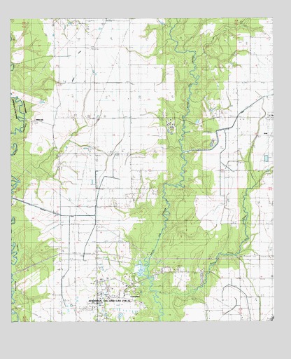
Evangeline, LA USGS Topographic Map
Click on map above to begin viewing in our Map Viewer.

This topographic map contains these locations and features:
Feature Name Type Latitude Longitude GNIS ID View Map
Acadia Solid Waste LandfillLocaleN30.2545°W92.5361°2600000View Map
Arcadiana Region Supports and Services CenterSchoolN30.3333°W92.5488°2493371View Map
Bayou Pointe Aux LoupsStreamN30.2608°W92.5415°553510View Map
Cartville (historical)Populated PlaceN30.3344°W92.5174°1630090View Map
Di's Cajun Restaurant AirportAirportN30.3731°W92.5810°2770265View Map
EvangelinePopulated PlaceN30.2624°W92.5707°543191View Map
Evangeline Elementary SchoolSchoolN30.2650°W92.5700°544349View Map
Evangeline Post OfficePost OfficeN30.2664°W92.5730°1630098View Map
Evangeline Volunteer Fire DepartmentBuildingN30.2718°W92.5851°2691730View Map
First Baptist Church of EvangelineChurchN30.2662°W92.5699°2601773View Map
Gatte CemeteryCemeteryN30.2971°W92.5687°535195View Map
Iota Elementary SchoolSchoolN30.3348°W92.5005°544364View Map
Iota Oil and Gas FieldOilfieldN30.3491°W92.5304°535938View Map
Iota RacetrackLocaleN30.3360°W92.5265°535939View Map
Iota Water Treatment FacilityLocaleN30.3174°W92.5035°2603376View Map
Jennings Oil and Gas FieldOilfieldN30.2599°W92.5824°554870View Map
L I and M CanalCanalN30.2858°W92.5026°532067View Map
L I and M CanalCanalN30.3299°W92.5218°532072View Map
Leckett CemeteryCemeteryN30.2566°W92.5824°536384View Map
Little Mamou CemeteryCemeteryN30.3171°W92.6029°536576View Map
Lodi (historical)Populated PlaceN30.3641°W92.5682°1630103View Map
Lontz School (historical)SchoolN30.3491°W92.5685°544725View Map
Mamou CanalCanalN30.3538°W92.5946°536869View Map
McFarlain CemeteryCemeteryN30.2524°W92.5837°536990View Map
Miller ChurchChurchN30.3071°W92.5682°537138View Map
MillervillePopulated PlaceN30.3330°W92.6165°555328View Map
NezpiquePopulated PlaceN30.3549°W92.6026°549393View Map
Oil Field School (historical)SchoolN30.2641°W92.5787°544731View Map
Oriza (historical)Populated PlaceN30.2574°W92.5071°549394View Map
Parish Governing Authority District 8CivilN30.3674°W92.5330°1930223View Map
Riverside CanalCanalN30.2946°W92.6057°538624View Map
Riverside CemeteryCemeteryN30.3071°W92.6154°538625View Map
Saint Josephs Catholic ChurchChurchN30.2659°W92.5720°2602674View Map
Saint Jules ChurchChurchN30.3188°W92.6026°538928View Map
United Pentecostal ChurchChurchN30.2704°W92.5539°2602922View Map
Ward FourCivilN30.3141°W92.5274°544882View Map
WhitehousePopulated PlaceN30.3141°W92.6029°549395View Map
Zaunbrecher StripAirportN30.3197°W92.5192°2676795View Map

Note: Coordinates in the location and feature list above are referenced to NAD83 datum.


Copyright (C) 2008-2025 Ryan Niemi / Sunset Dynamics ... All Rights Reserved