TopoQuest Logo
Do you find TopoQuest useful?
Help keep TopoQuest running and adding new maps/features by donating!
Bitcoin:  19c7KJd3qBynnjoSw5npx9KScwjBe4ifkT
Litecoin:  LXs6TkuXGGXo1vDsWCkWVdjQX94eUKd6ui
Home View Maps Find Maps Find Places Resources & Links


Fairfield, Maine Topographic Map

USGS Map Title: Fairfield, ME
USGS Map MRC: 44069E5
DRG (GeoTIFF) Download: o44069e5.tif


Neighboring USGS Topographic Map Quads:


  Hinckley, ME  
44069F6
 

  Clinton, ME  
44069F5
 

  Burnham, ME  
44069F4
 

  Waterville, ME  
44069E6
 

  Fairfield, ME  
44069E5
 

  Albion, ME  
44069E4
 

  Vassalboro, ME  
44069D6
 

  China Lake, ME  
44069D5
 

  Palermo, ME  
44069D4


Map MRC Location:

N45°
W70°
N45°
W69°
H8 H7 H6 H5 H4 H3 H2 H1
G8 G7 G6 G5 G4 G3 G2 G1
F8 F7 F6 F5 F4 F3 F2 F1
E8 E7 E6 E5 E4 E3 E2 E1
D8 D7 D6 D5 D4 D3 D2 D1
C8 C7 C6 C5 C4 C3 C2 C1
B8 B7 B6 B5 B4 B3 B2 B1
A8 A7 A6 A5 A4 A3 A2 A1
N44°
W70°
N44°
W69°

Fairfield, ME USGS 1:24K Topographic Map Preview:
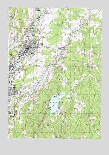
Fairfield, ME USGS Topographic Map
Click on map above to begin viewing in our Map Viewer.

This topographic map contains these locations and features:
Feature Name Type Latitude Longitude GNIS ID View Map
Ames CemeteryCemeteryN44.6003°W69.5874°561230View Map
Baker HillSummitN44.5081°W69.5012°561472View Map
Barton Hinds CemeteryCemeteryN44.5507°W69.5549°2736352View Map
Bellows StreamStreamN44.5187°W69.5770°562026View Map
BentonPopulated PlaceN44.5862°W69.5509°562068View Map
Benton Elementary SchoolSchoolN44.5888°W69.5782°2737981View Map
Benton FallsPopulated PlaceN44.5773°W69.5531°562070View Map
Benton StationPopulated PlaceN44.5892°W69.5850°562071View Map
Bob-Mar AirportAirportN44.5997°W69.6244°582147View Map
Brown CemeteryCemeteryN44.5692°W69.5136°563044View Map
Camp CaribouLocaleN44.5403°W69.5606°563388View Map
Central Maine SanatoriumHospitalN44.6067°W69.6059°563776View Map
East IslandIslandN44.5901°W69.5912°1908526View Map
East WinslowPopulated PlaceN44.5442°W69.5381°565703View Map
Emery BrookStreamN44.6034°W69.5953°565901View Map
Emery Hill CemeteryCemeteryN44.6058°W69.5956°565905View Map
FairfieldPopulated PlaceN44.5884°W69.5987°565993View Map
Fairfield Census Designated PlaceCensusN44.5892°W69.6067°2377906View Map
Fairfield Fire Department Station 1BuildingN44.5874°W69.5955°2552685View Map
Fairfield Historical SocietyBuildingN44.5878°W69.5995°1908540View Map
Fairfield Municipal BuildingBuildingN44.5876°W69.5959°1908541View Map
Fairfield Police DepartmentBuildingN44.5857°W69.5950°2735874View Map
Fairfield Post OfficePost OfficeN44.5863°W69.5951°2768980View Map
Fairfield Post Office (historical)Post OfficeN44.5865°W69.5953°1908542View Map
Fairfield Primary SchoolSchoolN44.5890°W69.5996°1908543View Map
Fairfield United Methodist ChurchChurchN44.5837°W69.6009°1908544View Map
Fitzgerald CemeteryCemeteryN44.6041°W69.5845°2736712View Map
Goodwin CornerPopulated PlaceN44.6198°W69.5764°579344View Map
Gowan CemeteryCemeteryN44.5126°W69.5103°2736722View Map
Gulliver IslandIslandN44.5826°W69.5945°1908554View Map
Hayden CornerPopulated PlaceN44.5248°W69.6189°579394View Map
History HouseBuildingN44.5878°W69.5995°1908567View Map
Holland BrookStreamN44.5723°W69.6114°568190View Map
Holt CemeteryCemeteryN44.6248°W69.5453°568217View Map
Interchange 35CrossingN44.5942°W69.6162°1908570View Map
Interchange 36CrossingN44.6017°W69.5989°1908571View Map
Kennebec Montessori SchoolSchoolN44.5894°W69.6241°2738173View Map
Kennebec River ReservoirReservoirN44.5639°W69.6204°1773656View Map
Kennebec Valley Community CollegeSchoolN44.5941°W69.6116°1908577View Map
Kennebec Valley Technical College Media CenterBuildingN44.5942°W69.6123°1908578View Map
Lambs CornerPopulated PlaceN44.5028°W69.5589°569344View Map
Lawrence High SchoolSchoolN44.5902°W69.6055°1908589View Map
Lawrence Junior High SchoolSchoolN44.5896°W69.6052°1908590View Map
Lawrence Public LibraryBuildingN44.5878°W69.5983°1908591View Map
Libbey IslandIslandN44.5856°W69.5920°1908594View Map
Lily IslandIslandN44.5987°W69.5931°1908595View Map
Lunder LibraryBuildingN44.5960°W69.6103°2738382View Map
Maplewood CemeteryCemeteryN44.5948°W69.6006°570750View Map
McClintock CemeteryCemeteryN44.5287°W69.5313°570953View Map
Middle IslandIslandN44.5915°W69.5931°1908620View Map
Monument ParkParkN44.5884°W69.6153°1908621View Map
Outlet StreamStreamN44.5356°W69.6112°572872View Map
Paines CornerPopulated PlaceN44.5126°W69.5739°572931View Map
Pattee PondLakeN44.5343°W69.5613°573060View Map
Pattee Pond BrookStreamN44.5698°W69.5642°573061View Map
Reed CemeteryCemeteryN44.5901°W69.5436°574120View Map
Reed Family CemeteryCemeteryN44.5740°W69.5572°2736762View Map
Saint John Regional Catholic SchoolSchoolN44.5449°W69.6220°2738154View Map
T and A Mills DamDamN44.5639°W69.6204°1773655View Map
Town of BentonCivilN44.5951°W69.5174°582350View Map
Town of WinslowCivilN44.5277°W69.5768°582820View Map
Tozier Mills CemeteryCemeteryN44.5818°W69.5558°2736777View Map
WEBB-FM (Waterville)TowerN44.5643°W69.6104°582308View Map
Wilson BrookStreamN44.5465°W69.5089°578538View Map
Wilson CemeteryCemeteryN44.5559°W69.5300°578540View Map
WinslowPopulated PlaceN44.5470°W69.6212°578593View Map
Winslow Census Designated PlaceCensusN44.5277°W69.5768°2377968View Map
Winslow Elementary SchoolSchoolN44.5551°W69.6181°2737930View Map
Winslow Fire DepartmentBuildingN44.5510°W69.6234°2552927View Map
Winslow High SchoolSchoolN44.5507°W69.6183°2737931View Map
Winslow Junior High SchoolSchoolN44.5509°W69.6211°2737932View Map
Winslow Police DepartmentBuildingN44.5510°W69.6235°2735859View Map
Winslow Post OfficePost OfficeN44.5456°W69.6156°2789362View Map
Winslow Public LibraryBuildingN44.5432°W69.6116°2738457View Map
WTVL-AM (Waterville)TowerN44.5645°W69.6103°582279View Map

Note: Coordinates in the location and feature list above are referenced to NAD83 datum.


Copyright (C) 2008-2024 Ryan Niemi / Sunset Dynamics ... All Rights Reserved