TopoQuest Logo
Do you find TopoQuest useful?
Help keep TopoQuest running and adding new maps/features by donating!
Bitcoin:  19c7KJd3qBynnjoSw5npx9KScwjBe4ifkT
Litecoin:  LXs6TkuXGGXo1vDsWCkWVdjQX94eUKd6ui
Home View Maps Find Maps Find Places Resources & Links


Palermo, Maine Topographic Map

USGS Map Title: Palermo, ME
USGS Map MRC: 44069D4
DRG (GeoTIFF) Download: o44069d4.tif


Neighboring USGS Topographic Map Quads:


  Fairfield, ME  
44069E5
 

  Albion, ME  
44069E4
 

  Unity, ME  
44069E3
 

  China Lake, ME  
44069D5
 

  Palermo, ME  
44069D4
 

  Liberty, ME  
44069D3
 

  Weeks Mills, ME  
44069C5
 

  Razorville, ME  
44069C4
 

  Washington, ME  
44069C3


Map MRC Location:

N45°
W70°
N45°
W69°
H8 H7 H6 H5 H4 H3 H2 H1
G8 G7 G6 G5 G4 G3 G2 G1
F8 F7 F6 F5 F4 F3 F2 F1
E8 E7 E6 E5 E4 E3 E2 E1
D8 D7 D6 D5 D4 D3 D2 D1
C8 C7 C6 C5 C4 C3 C2 C1
B8 B7 B6 B5 B4 B3 B2 B1
A8 A7 A6 A5 A4 A3 A2 A1
N44°
W70°
N44°
W69°

Palermo, ME USGS 1:24K Topographic Map Preview:
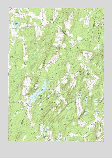
Palermo, ME USGS Topographic Map
Click on map above to begin viewing in our Map Viewer.

This topographic map contains these locations and features:
Feature Name Type Latitude Longitude GNIS ID View Map
Bear PondLakeN44.3972°W69.4247°561859View Map
Beech PondLakeN44.3853°W69.4505°561994View Map
Belden PondLakeN44.4134°W69.3857°562009View Map
Blake PondLakeN44.4239°W69.4484°562554View Map
Bowler PondLakeN44.4184°W69.4065°562802View Map
Branch Mills CemeteryCemeteryN44.4106°W69.4800°562893View Map
Branch PondReservoirN44.4185°W69.4615°562894View Map
Carrs CornerPopulated PlaceN44.4401°W69.4089°579180View Map
Center CemeteryCemeteryN44.4178°W69.4281°563745View Map
ColesPopulated PlaceN44.4537°W69.4964°579208View Map
Dennis Hill CemeteryCemeteryN44.4167°W69.4323°565042View Map
Dowe PondLakeN44.4055°W69.4578°565256View Map
Dutton PondLakeN44.4847°W69.4899°565444View Map
Foster PondLakeN44.4145°W69.3983°566461View Map
Greeley Corner CemeteryCemeteryN44.3791°W69.4541°2725332View Map
Greeley Corner CemeteryCemeteryN44.3783°W69.4531°2725333View Map
Greely ChurchChurchN44.3784°W69.4531°567197View Map
Greely CornerPopulated PlaceN44.3765°W69.4487°579361View Map
Hackmatack PondLakeN44.4016°W69.4623°567411View Map
Hutchins CornerPopulated PlaceN44.4848°W69.3773°579426View Map
Jose PondLakeN44.4158°W69.4591°569001View Map
Jump PondLakeN44.4027°W69.3983°569020View Map
Level HillSummitN44.4067°W69.4084°569490View Map
Libby CemeteryCemeteryN44.4876°W69.4448°569523View Map
Lincoln CemeteryCemeteryN44.4945°W69.4878°569599View Map
Little Jose PondLakeN44.4166°W69.4555°569859View Map
Mill DamDamN44.4089°W69.4741°1774261View Map
Mud PondLakeN44.3916°W69.4273°571893View Map
North PalermoPopulated PlaceN44.4515°W69.3945°579573View Map
Osgood CemeteryCemeteryN44.4587°W69.4348°572787View Map
PalermoPopulated PlaceN44.4078°W69.4739°572934View Map
Palermo Consolidated SchoolSchoolN44.3885°W69.4675°572935View Map
Palermo First Respond Ambulance ServiceBuildingN44.4078°W69.4719°2666791View Map
Palermo Post OfficePost OfficeN44.4052°W69.4727°2768906View Map
Palermo Volunteer Fire Department Central StationBuildingN44.4078°W69.4718°2552978View Map
Parmeter CemeteryCemeteryN44.4076°W69.4367°573012View Map
Perkins CemeteryCemeteryN44.4356°W69.4237°573202View Map
Pleasant Ridge CemeteryCemeteryN44.4466°W69.4791°2736759View Map
Prescott PondLakeN44.4389°W69.3984°573785View Map
Saban PondLakeN44.4065°W69.4200°574625View Map
Sanford HillSummitN44.4545°W69.3750°574904View Map
Sennetts CornerPopulated PlaceN44.4884°W69.4417°579686View Map
Smith CemeteryCemeteryN44.4412°W69.3942°575616View Map
Town of PalermoCivilN44.3960°W69.4271°582659View Map
Yorktown BrookStreamN44.4856°W69.4395°578790View Map

Note: Coordinates in the location and feature list above are referenced to NAD83 datum.


Copyright (C) 2008-2025 Ryan Niemi / Sunset Dynamics ... All Rights Reserved