TopoQuest Logo
Do you find TopoQuest useful?
Help keep TopoQuest running and adding new maps/features by donating!
Bitcoin:  19c7KJd3qBynnjoSw5npx9KScwjBe4ifkT
Litecoin:  LXs6TkuXGGXo1vDsWCkWVdjQX94eUKd6ui
Home View Maps Find Maps Find Places Resources & Links


Fairplay East, Colorado Topographic Map

USGS Map Title: Fairplay East, CO
USGS Map MRC: 39105B8
DRG (GeoTIFF) Download: o39105b8.tif


Neighboring USGS Topographic Map Quads:


  Alma, CO  
39106C1
 

  Como, CO  
39105C8
 

  Milligan Lakes, CO  
39105C7
 

  Fairplay West, CO  
39106B1
 

  Fairplay East, CO  
39105B8
 

  Elkhorn, CO  
39105B7
 

  Jones Hill, CO  
39106A1
 

  Garo, CO  
39105A8
 

  Hartsel, CO  
39105A7


Map MRC Location:

N40°
W106°
N40°
W105°
H8 H7 H6 H5 H4 H3 H2 H1
G8 G7 G6 G5 G4 G3 G2 G1
F8 F7 F6 F5 F4 F3 F2 F1
E8 E7 E6 E5 E4 E3 E2 E1
D8 D7 D6 D5 D4 D3 D2 D1
C8 C7 C6 C5 C4 C3 C2 C1
B8 B7 B6 B5 B4 B3 B2 B1
A8 A7 A6 A5 A4 A3 A2 A1
N39°
W106°
N39°
W105°

Fairplay East, CO USGS 1:24K Topographic Map Preview:
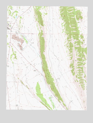
Fairplay East, CO USGS Topographic Map
Click on map above to begin viewing in our Map Viewer.

This topographic map contains these locations and features:
Feature Name Type Latitude Longitude GNIS ID View Map
Alkaline DitchCanalN39.1686°W105.9514°183597View Map
Anderson Ditch Number 1CanalN39.2278°W105.9756°183607View Map
Anderson Ditch Number 2CanalN39.2200°W105.9733°183606View Map
Anderson Ditch Number 3CanalN39.2105°W105.9631°183605View Map
Annex RanchLocaleN39.1625°W105.9197°183612View Map
Beaver CreekStreamN39.2175°W105.9820°179976View Map
Bonell DitchCanalN39.1736°W105.9592°183599View Map
Buyer RanchLocaleN39.2053°W105.9611°183602View Map
Cargill RanchLocaleN39.1728°W105.9550°183598View Map
Coil RanchLocaleN39.2172°W105.9611°183604View Map
Colorado Springs RanchLocaleN39.1286°W105.9833°183615View Map
Colorado State Patrol Fairplay PostBuildingN39.2235°W105.9891°2757337View Map
Crooked CreekStreamN39.1883°W105.9481°183406View Map
Crooked Creek DitchCanalN39.2300°W105.9597°183608View Map
D F Miller DitchCanalN39.2030°W105.9678°183617View Map
Fairplay CemeteryCemeteryN39.2219°W105.9814°183609View Map
Fairplay Police DepartmentBuildingN39.2214°W105.9966°2696619View Map
Malice DitchCanalN39.1328°W105.9806°183616View Map
Meier RidgeRidgeN39.1884°W105.9878°2772063View Map
Miller-Chapman DitchCanalN39.2092°W105.9625°183603View Map
North - West Fire Protection District Station 2BuildingN39.2094°W105.9962°2666993View Map
Old Fairplay CemeteryCemeteryN39.2233°W105.9836°2379337View Map
Park County JailBuildingN39.2236°W105.9887°2696642View Map
Park County Sheriff's OfficeBuildingN39.2236°W105.9889°2696615View Map
Park DitchCanalN39.1955°W105.9564°183601View Map
Platte RanchLocaleN39.1405°W105.9289°183613View Map
Raynor-Edmonson DitchesCanalN39.1405°W105.9345°183614View Map
Red HillRidgeN39.2410°W105.9523°202939View Map
Reinecker RidgeRidgeN39.2279°W105.9016°183415View Map
Sigafus DitchCanalN39.1292°W105.9056°183610View Map
South Park Ambulance DistrictBuildingN39.2237°W105.9943°2695573View Map
Temple RanchLocaleN39.1769°W105.9995°183600View Map
Town of FairplayCivilN39.2245°W105.9959°2412616View Map
Trout Creek DitchCanalN39.1625°W105.9120°202948View Map
Trout Creek RanchLocaleN39.1353°W105.8992°183611View Map

Note: Coordinates in the location and feature list above are referenced to NAD83 datum.


Copyright (C) 2008-2024 Ryan Niemi / Sunset Dynamics ... All Rights Reserved