TopoQuest Logo
Do you find TopoQuest useful?
Help keep TopoQuest running and adding new maps/features by donating!
Bitcoin:  19c7KJd3qBynnjoSw5npx9KScwjBe4ifkT
Litecoin:  LXs6TkuXGGXo1vDsWCkWVdjQX94eUKd6ui
Home View Maps Find Maps Find Places Resources & Links


Fairplay West, Colorado Topographic Map

USGS Map Title: Fairplay West, CO
USGS Map MRC: 39106B1
DRG (GeoTIFF) Download: o39106b1.tif


Neighboring USGS Topographic Map Quads:


  Climax, CO  
39106C2
 

  Alma, CO  
39106C1
 

  Como, CO  
39105C8
 

  Mount Sherman, CO  
39106B2
 

  Fairplay West, CO  
39106B1
 

  Fairplay East, CO  
39105B8
 

  South Peak, CO  
39106A2
 

  Jones Hill, CO  
39106A1
 

  Garo, CO  
39105A8


Map MRC Location:

N40°
W107°
N40°
W106°
H8 H7 H6 H5 H4 H3 H2 H1
G8 G7 G6 G5 G4 G3 G2 G1
F8 F7 F6 F5 F4 F3 F2 F1
E8 E7 E6 E5 E4 E3 E2 E1
D8 D7 D6 D5 D4 D3 D2 D1
C8 C7 C6 C5 C4 C3 C2 C1
B8 B7 B6 B5 B4 B3 B2 B1
A8 A7 A6 A5 A4 A3 A2 A1
N39°
W107°
N39°
W106°

Fairplay West, CO USGS 1:24K Topographic Map Preview:
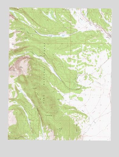
Fairplay West, CO USGS Topographic Map
Click on map above to begin viewing in our Map Viewer.

This topographic map contains these locations and features:
Feature Name Type Latitude Longitude GNIS ID View Map
Almgren Tie CampLocaleN39.1486°W106.0803°196750View Map
Barco MineMineN39.2022°W106.1161°180240View Map
Breakneck PassGapN39.1486°W106.0781°180244View Map
Browns PassGapN39.1742°W106.0992°180236View Map
Columbia Number 1 DitchCanalN39.2464°W106.0300°180251View Map
Denver MineMineN39.2194°W106.1175°1684834View Map
Duguesne SmelterLocaleN39.2269°W106.0447°196929View Map
East LeadvilleLocaleN39.2036°W106.0836°196927View Map
Emma MineMineN39.2244°W106.1192°1684835View Map
FairplayPopulated PlaceN39.2247°W106.0020°169534View Map
Fairplay Mining DitchCanalN39.2358°W106.0228°180250View Map
Fairplay Post OfficePost OfficeN39.2250°W106.0011°2734594View Map
Four Mile CampgroundLocaleN39.2097°W106.1047°196924View Map
Fourmile Number 9 DitchCanalN39.1772°W106.0089°180252View Map
Freedom MineMineN39.2339°W106.1222°1684836View Map
High Creek DitchCanalN39.1661°W106.0361°196751View Map
HollandLocaleN39.2486°W106.0534°196928View Map
Horseshoe (historical)Populated PlaceN39.2039°W106.0853°180239View Map
Horseshoe CampgroundLocaleN39.2017°W106.0867°196926View Map
Kurt MineMineN39.2269°W106.1195°1684837View Map
Lamb MountainSummitN39.1903°W106.1214°180237View Map
Limber Grove TrailTrailN39.2030°W106.0970°196925View Map
Little Nell MineMineN39.2194°W106.1172°1684838View Map
Little Nellie MineMineN39.2294°W106.1206°1684839View Map
Little Sacramento GulchValleyN39.2260°W106.0899°180228View Map
Michigan MineMineN39.2089°W106.1192°1684840View Map
Mudsill MineMineN39.2105°W106.1167°1684841View Map
Mudsill SpringSpringN39.2153°W106.1189°180241View Map
MullenvilleLocaleN39.1639°W106.0595°196749View Map
Peart Lower DitchCanalN39.1839°W106.0359°180253View Map
Peart Upper DitchCanalN39.1847°W106.0428°180247View Map
Pennsylvania CreekStreamN39.2469°W106.0445°179895View Map
Placer DitchCanalN39.1675°W106.0525°197354View Map
Platte River Placers MineMineN39.2336°W106.0203°1684842View Map
Revenue MineMineN39.2100°W106.1178°1684843View Map
Rhodes Warm SpringSpringN39.1639°W106.0625°1794714View Map
Rhodes Warm SpringsSpringN39.1636°W106.0653°1735261View Map
Rogers DitchCanalN39.1492°W106.0242°180248View Map
Round HillSummitN39.1353°W106.0639°180245View Map
SacramentoLocaleN39.2214°W106.1075°180242View Map
Sacramento CreekStreamN39.2339°W106.0256°180229View Map
Sacramento DitchStreamN39.2050°W106.0367°196930View Map
Sacramento HeliportAirportN39.2161°W106.0872°204394View Map
Sacramento MineMineN39.2211°W106.1084°1684844View Map
Sheep MountainSummitN39.1936°W106.1120°180238View Map
Sheep ParkFlatN39.1644°W106.1025°180234View Map
Sheep RidgeRidgeN39.1703°W106.0909°180235View Map
Sherwood MineMineN39.2258°W106.1195°1684845View Map
Silver Star MineMineN39.2233°W106.1170°1684846View Map
Sitting Bull MineMineN39.2289°W106.1200°1684847View Map
South Crooked CreekStreamN39.2411°W106.0056°180006View Map
South Park City MuseumParkN39.2253°W106.0045°2091285View Map
Spar MineMineN39.2086°W106.1203°1684848View Map
Thompson ParkFlatN39.2028°W106.0617°196385View Map
Troy MineMineN39.2003°W106.1167°1684849View Map
Warm Springs DitchCanalN39.1636°W106.0511°180246View Map
Watseka MineMineN39.2222°W106.1070°1684850View Map
Westerman DitchCanalN39.2294°W106.0225°180249View Map

Note: Coordinates in the location and feature list above are referenced to NAD83 datum.


Copyright (C) 2008-2024 Ryan Niemi / Sunset Dynamics ... All Rights Reserved