TopoQuest Logo
Do you find TopoQuest useful?
Help keep TopoQuest running and adding new maps/features by donating!
Bitcoin:  19c7KJd3qBynnjoSw5npx9KScwjBe4ifkT
Litecoin:  LXs6TkuXGGXo1vDsWCkWVdjQX94eUKd6ui
Home View Maps Find Maps Find Places Resources & Links


Farnum Peak, Colorado Topographic Map

USGS Map Title: Farnum Peak, CO
USGS Map MRC: 39105B5
DRG (GeoTIFF) Download: o39105b5.tif


Neighboring USGS Topographic Map Quads:


  Observatory Rock, CO  
39105C6
 

  Topaz Mountain, CO  
39105C5
 

  Windy Peak, CO  
39105C4
 

  Eagle Rock, CO  
39105B6
 

  Farnum Peak, CO  
39105B5
 

  McCurdy Mountain, CO  
39105B4
 

  Sulphur Mountain, CO  
39105A6
 

  Glentivar, CO  
39105A5
 

  Tarryall, CO  
39105A4


Map MRC Location:

N40°
W106°
N40°
W105°
H8 H7 H6 H5 H4 H3 H2 H1
G8 G7 G6 G5 G4 G3 G2 G1
F8 F7 F6 F5 F4 F3 F2 F1
E8 E7 E6 E5 E4 E3 E2 E1
D8 D7 D6 D5 D4 D3 D2 D1
C8 C7 C6 C5 C4 C3 C2 C1
B8 B7 B6 B5 B4 B3 B2 B1
A8 A7 A6 A5 A4 A3 A2 A1
N39°
W106°
N39°
W105°

Farnum Peak, CO USGS 1:24K Topographic Map Preview:
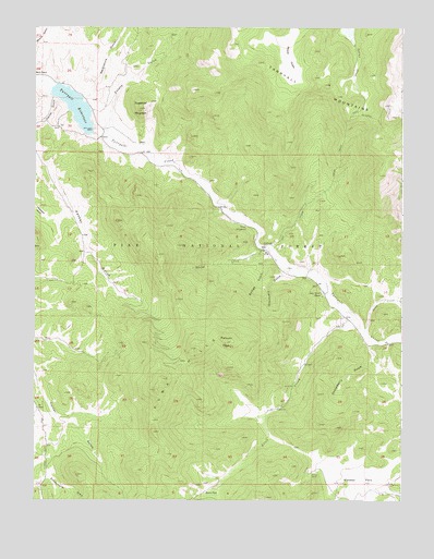
Farnum Peak, CO USGS Topographic Map
Click on map above to begin viewing in our Map Viewer.

This topographic map contains these locations and features:
Feature Name Type Latitude Longitude GNIS ID View Map
Allen Anderson DitchCanalN39.1858°W105.5302°2710930View Map
Allen CreekStreamN39.1750°W105.5178°183652View Map
Anderson Allen DitchCanalN39.1799°W105.5239°2710944View Map
Anson Allen DitchCanalN39.1716°W105.5146°2710952View Map
Bonis GulchValleyN39.2468°W105.6244°183488View Map
Bridge GulchValleyN39.1893°W105.5433°183655View Map
Burns ParkFlatN39.1267°W105.5658°202951View Map
Derbyshire GulchValleyN39.2306°W105.6082°183489View Map
Farnum CemeteryCemeteryN39.1864°W105.5392°2379348View Map
Farnum DitchCanalN39.1866°W105.5377°2712029View Map
Farnum PeakSummitN39.1669°W105.5600°183656View Map
Gooseberry GulchValleyN39.1664°W105.5096°183635View Map
Graveyard GulchValleyN39.1856°W105.5392°183654View Map
Indian Creek TrailTrailN39.2283°W105.5153°202942View Map
Lazy River RanchLocaleN39.1797°W105.5278°183653View Map
Packer Bonis DitchCanalN39.2368°W105.6213°2723976View Map
Packer GulchValleyN39.2317°W105.6187°183651View Map
Potato GulchValleyN39.2224°W105.6057°183662View Map
Sand CreekStreamN39.1703°W105.5131°183663View Map
Second CreekStreamN39.1922°W105.5450°183657View Map
Sugarloaf MountainSummitN39.2286°W105.5894°183660View Map
Tarryall CampgroundLocaleN39.1969°W105.5531°183659View Map
Tarryall DamDamN39.2225°W105.6056°198808View Map
Tarryall MountainsRangeN39.2322°W105.5281°202941View Map
Tarryall ReservoirReservoirN39.2289°W105.6116°183661View Map
Ute CreekStreamN39.1914°W105.5444°183658View Map
Ute Creek TrailheadLocaleN39.2019°W105.5619°197563View Map
Webber ParkFlatN39.1305°W105.5150°202949View Map

Note: Coordinates in the location and feature list above are referenced to NAD83 datum.


Copyright (C) 2008-2024 Ryan Niemi / Sunset Dynamics ... All Rights Reserved