TopoQuest Logo
Do you find TopoQuest useful?
Help keep TopoQuest running and adding new maps/features by donating!
Bitcoin:  19c7KJd3qBynnjoSw5npx9KScwjBe4ifkT
Litecoin:  LXs6TkuXGGXo1vDsWCkWVdjQX94eUKd6ui
Home View Maps Find Maps Find Places Resources & Links


Glentivar, Colorado Topographic Map

USGS Map Title: Glentivar, CO
USGS Map MRC: 39105A5
DRG (GeoTIFF) Download: o39105a5.tif


Neighboring USGS Topographic Map Quads:


  Eagle Rock, CO  
39105B6
 

  Farnum Peak, CO  
39105B5
 

  McCurdy Mountain, CO  
39105B4
 

  Sulphur Mountain, CO  
39105A6
 

  Glentivar, CO  
39105A5
 

  Tarryall, CO  
39105A4
 

  Guffey NW, CO  
38105H6
 

  Spinney Mountain, CO  
38105H5
 

  Elevenmile Canyon, CO  
38105H4


Map MRC Location:

N40°
W106°
N40°
W105°
H8 H7 H6 H5 H4 H3 H2 H1
G8 G7 G6 G5 G4 G3 G2 G1
F8 F7 F6 F5 F4 F3 F2 F1
E8 E7 E6 E5 E4 E3 E2 E1
D8 D7 D6 D5 D4 D3 D2 D1
C8 C7 C6 C5 C4 C3 C2 C1
B8 B7 B6 B5 B4 B3 B2 B1
A8 A7 A6 A5 A4 A3 A2 A1
N39°
W106°
N39°
W105°

Glentivar, CO USGS 1:24K Topographic Map Preview:
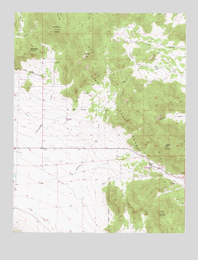
Glentivar, CO USGS Topographic Map
Click on map above to begin viewing in our Map Viewer.

This topographic map contains these locations and features:
Feature Name Type Latitude Longitude GNIS ID View Map
Antelope AirparkAirportN39.0253°W105.6085°2443916View Map
Badger MountainSummitN39.0489°W105.5128°183805View Map
Badger Mountain HeliportAirportN39.0492°W105.5136°204597View Map
Big Sheep Horn Claim MineMineN39.0744°W105.5786°1703824View Map
Blue-green Lode Number One MineMineN39.0567°W105.5322°1703825View Map
Blue-green Lode Number Two MineMineN39.0567°W105.5322°1703826View Map
Christie-Ward-Lucky Thirteen Number One MineMineN39.0567°W105.5322°1703827View Map
GlentivarPopulated PlaceN39.0478°W105.6042°196735View Map
Great Western MineMineN39.0389°W105.5206°1703828View Map
La Salle PassGapN39.0850°W105.5467°183812View Map
Martland GulchValleyN39.0010°W105.5962°183809View Map
Martland PeakSummitN39.1008°W105.5742°183813View Map
Meteor MineMineN39.0353°W105.6053°1735981View Map
Pipe Springs CampgroundLocaleN39.0278°W105.5067°196731View Map
Pulver MountainSummitN39.0111°W105.5172°183808View Map
Puma HillsRangeN39.0297°W105.5081°183664View Map
Rishaberger MountainSummitN39.1050°W105.6122°183817View Map
Rishaberger SpringSpringN39.0964°W105.5956°183815View Map
Roger Publishing Company MineMineN39.0478°W105.5414°1703823View Map
Schoolmarm MountainSummitN39.1153°W105.5942°183816View Map
Wilkerson PassGapN39.0380°W105.5256°183807View Map
Wilkerson Pass Visitor CenterLocaleN39.0372°W105.5250°196730View Map

Note: Coordinates in the location and feature list above are referenced to NAD83 datum.


Copyright (C) 2008-2024 Ryan Niemi / Sunset Dynamics ... All Rights Reserved