TopoQuest Logo
Do you find TopoQuest useful?
Help keep TopoQuest running and adding new maps/features by donating!
Bitcoin:  19c7KJd3qBynnjoSw5npx9KScwjBe4ifkT
Litecoin:  LXs6TkuXGGXo1vDsWCkWVdjQX94eUKd6ui
Home View Maps Find Maps Find Places Resources & Links


Fayette, Mississippi Topographic Map

USGS Map Title: Fayette, MS
USGS Map MRC: 31091F1
DRG (GeoTIFF) Download: o31091f1.tif


Neighboring USGS Topographic Map Quads:


  Rodney, MS  
31091G2
 

  Lorman, MS  
31091G1
 

  Red Lick, MS  
31090G8
 

  Church Hill, MS  
31091F2
 

  Fayette, MS  
31091F1
 

  Gin Branch, MS  
31090F8
 

  Cranfield, MS  
31091E2
 

  Roxie, MS  
31091E1
 

  Kirby, MS  
31090E8


Map MRC Location:

N32°
W92°
N32°
W91°
H8 H7 H6 H5 H4 H3 H2 H1
G8 G7 G6 G5 G4 G3 G2 G1
F8 F7 F6 F5 F4 F3 F2 F1
E8 E7 E6 E5 E4 E3 E2 E1
D8 D7 D6 D5 D4 D3 D2 D1
C8 C7 C6 C5 C4 C3 C2 C1
B8 B7 B6 B5 B4 B3 B2 B1
A8 A7 A6 A5 A4 A3 A2 A1
N31°
W92°
N31°
W91°

Fayette, MS USGS 1:24K Topographic Map Preview:
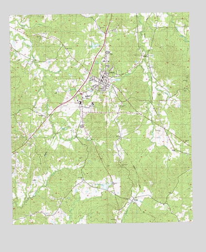
Fayette, MS USGS Topographic Map
Click on map above to begin viewing in our Map Viewer.

This topographic map contains these locations and features:
Feature Name Type Latitude Longitude GNIS ID View Map
American Legion LakeReservoirN31.6476°W91.0593°666242View Map
American Legion Lake DamDamN31.6468°W91.0618°680804View Map
Beaver BranchStreamN31.7104°W91.0276°666694View Map
Bethel CemeteryCemeteryN31.7043°W91.0034°666878View Map
Bolls CemeteryCemeteryN31.7018°W91.0226°667411View Map
CadillacPopulated PlaceN31.6516°W91.1104°691745View Map
Cadillac Oil FieldOilfieldN31.6377°W91.0654°691011View Map
City of FayetteCivilN31.7122°W91.0621°2403600View Map
Community ChurchChurchN31.6899°W91.1021°668727View Map
County Voc-Tech SchoolSchoolN31.7010°W91.0729°689817View Map
Darden CemeteryCemeteryN31.6835°W91.0832°669108View Map
Deane (historical)Populated PlaceN31.7118°W91.0276°707693View Map
Doyles BranchStreamN31.7199°W91.0345°669376View Map
Fairchilds CreekStreamN31.7174°W91.1007°669869View Map
FayettePopulated PlaceN31.7116°W91.0607°669927View Map
Fayette Baptist ChurchChurchN31.7132°W91.0604°686419View Map
Fayette Fire DepartmentBuildingN31.7117°W91.0601°2667678View Map
Fayette Police DepartmentBuildingN31.7113°W91.0603°2754204View Map
Fayette Post OfficePost OfficeN31.7129°W91.0593°2768650View Map
Folkes CemeteryCemeteryN31.6729°W91.1112°670067View Map
Forest Grove ChurchChurchN31.7368°W91.1012°670088View Map
Fountain ChapelChurchN31.6679°W91.0112°670122View Map
Gibson CemeteryCemeteryN31.7421°W91.1157°670379View Map
Gravel Hill ChurchChurchN31.6760°W91.0484°670613View Map
Greenleaf ChurchChurchN31.7177°W91.0287°689818View Map
Greenleaf ChurchChurchN31.7171°W91.0284°691005View Map
Grover Brown Lake DamDamN31.7368°W91.1218°680867View Map
Hamblin CemeteryCemeteryN31.7346°W91.1204°670854View Map
HarristonPopulated PlaceN31.7252°W91.0323°670984View Map
Hicks CemeteryCemeteryN31.7107°W91.0807°671180View Map
Hinds CemeteryCemeteryN31.7235°W91.1187°671231View Map
Hughes CemeteryCemeteryN31.6949°W91.1062°671568View Map
Hughes CreekStreamN31.7174°W91.1007°671570View Map
Jefferson - Franklin County / Regional Correctional FacilityBuildingN31.7011°W91.0749°2739802View Map
Jefferson CountyCivilN31.7342°W91.0372°695755View Map
Jefferson County Elementary SchoolSchoolN31.7110°W91.0576°707696View Map
Jefferson County High SchoolSchoolN31.7218°W91.0570°707697View Map
Jefferson County HospitalHospitalN31.7050°W91.0680°2672743View Map
Jefferson County Sheriff's OfficeBuildingN31.7011°W91.0749°2754258View Map
Jefferson Vocational Technical SchoolSchoolN31.7010°W91.0729°691006View Map
John Berry Lake DamDamN31.7285°W91.1218°680858View Map
Jones CemeteryCemeteryN31.6593°W91.0584°671962View Map
Krauss LakeReservoirN31.7309°W91.0669°672217View Map
Krauss Lake DamDamN31.7302°W91.0668°680859View Map
Krauss Lake DamDamN31.7318°W91.0668°680862View Map
Krauss Lake DamDamN31.7335°W91.0634°680864View Map
Liddell Elementary SchoolSchoolN31.6988°W91.0793°707699View Map
Liddell High SchoolSchoolN31.6971°W91.0759°672489View Map
Little CreekStreamN31.6807°W91.0948°672580View Map
Locust Grove ChurchChurchN31.7418°W91.0623°672750View Map
Marble CemeteryCemeteryN31.6646°W91.0773°673124View Map
McGinty BayouStreamN31.7074°W91.1015°673360View Map
McNairPopulated PlaceN31.6385°W91.0420°673411View Map
Montgomery CemeteryCemeteryN31.6799°W91.0207°673740View Map
Mossy LakeReservoirN31.6820°W91.0870°673885View Map
Mount Zion Church of God in ChristChurchN31.7054°W91.0607°686426View Map
Old Gravel Hill CemeteryCemeteryN31.6596°W91.0487°675191View Map
Phoenix (historical)Populated PlaceN31.7377°W91.0584°686431View Map
Pine Grove ChurchChurchN31.6521°W91.0759°675828View Map
Pine Grove ChurchChurchN31.7093°W91.0012°675830View Map
Puffel CemeteryCemeteryN31.6429°W91.0143°676411View Map
Rose Hill Number 1 ChurchChurchN31.6274°W91.0534°689819View Map
Rose Hill Number 1 ChurchChurchN31.6271°W91.0534°691007View Map
Rose Hill Number 2 ChurchChurchN31.7185°W91.1146°676867View Map
Saint Anthonys ChurchChurchN31.7416°W91.0215°677012View Map
Salem Baptist Church (historical)ChurchN31.6285°W91.1246°707703View Map
Sims CemeteryCemeteryN31.7421°W91.0018°677834View Map
South Fayette Oil FieldOilfieldN31.7041°W91.0923°691019View Map
Spring Hill Meetinghouse (historical)ChurchN31.6668°W91.0948°686439View Map
Stuart CemeteryCemeteryN31.7349°W91.0501°678374View Map
Supervisor District 3CivilN31.6978°W91.1057°711911View Map
Trullys Lake DamDamN31.6835°W91.0884°680826View Map
Whiten CemeteryCemeteryN31.6949°W91.0476°679628View Map
WTYJ-FM (Fayette)TowerN31.6757°W91.1051°680199View Map

Note: Coordinates in the location and feature list above are referenced to NAD83 datum.


Copyright (C) 2008-2025 Ryan Niemi / Sunset Dynamics ... All Rights Reserved