TopoQuest Logo
Do you find TopoQuest useful?
Help keep TopoQuest running and adding new maps/features by donating!
Bitcoin:  19c7KJd3qBynnjoSw5npx9KScwjBe4ifkT
Litecoin:  LXs6TkuXGGXo1vDsWCkWVdjQX94eUKd6ui
Home View Maps Find Maps Find Places Resources & Links


Arredondo, Florida Topographic Map

USGS Map Title: Arredondo, FL
USGS Map MRC: 29082E4
DRG (GeoTIFF) Download: o29082e4.tif


Neighboring USGS Topographic Map Quads:


  Newberry, FL  
29082F5
 

  Gainesville West, FL  
29082F4
 

  Gainesville East, FL  
29082F3
 

  Archer, FL  
29082E5
 

  Arredondo, FL  
29082E4
 

  Micanopy, FL  
29082E3
 

  Bronson NE, FL  
29082D5
 

  Williston, FL  
29082D4
 

  Flemington, FL  
29082D3


Map MRC Location:

N30°
W83°
N30°
W82°
H8 H7 H6 H5 H4 H3 H2 H1
G8 G7 G6 G5 G4 G3 G2 G1
F8 F7 F6 F5 F4 F3 F2 F1
E8 E7 E6 E5 E4 E3 E2 E1
D8 D7 D6 D5 D4 D3 D2 D1
C8 C7 C6 C5 C4 C3 C2 C1
B8 B7 B6 B5 B4 B3 B2 B1
A8 A7 A6 A5 A4 A3 A2 A1
N29°
W83°
N29°
W82°

Arredondo, FL USGS 1:24K Topographic Map Preview:
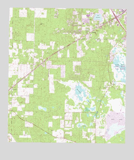
Arredondo, FL USGS Topographic Map
Click on map above to begin viewing in our Map Viewer.

This topographic map contains these locations and features:
Feature Name Type Latitude Longitude GNIS ID View Map
Alachua County Fire Rescue Station 15BuildingN29.5891°W82.4364°2082202View Map
ArredondoPopulated PlaceN29.6050°W82.4093°277959View Map
Arredondo EstatesPopulated PlaceN29.6050°W82.4162°301330View Map
Arredondo Farms Mobile Home ParkPopulated PlaceN29.5985°W82.4160°2449149View Map
Bible Truth ChapelChurchN29.5592°W82.4858°2447599View Map
Butler Plaza West Shopping CenterLocaleN29.6216°W82.3831°2449222View Map
Calvary ChapelChurchN29.5975°W82.4021°2072294View Map
Celebration United Methodist ChurchChurchN29.5900°W82.4368°2449162View Map
Christian Life WorldChurchN29.5703°W82.4708°2111053View Map
ClinchPopulated PlaceN29.5744°W82.3920°301120View Map
D L Clinch GrantCivilN29.5783°W82.3934°300394View Map
Dogwood ParkParkN29.6081°W82.4019°2111045View Map
Einstein Montessori SchoolSchoolN29.6072°W82.4069°2111044View Map
Elim Church (historical)ChurchN29.6072°W82.4059°282153View Map
Faith Tabernacle of Praise MinistriesChurchN29.6031°W82.4069°2111051View Map
Forest Lake Golf ClubLocaleN29.6101°W82.4468°2449140View Map
Fort Wacahoota (historical)MilitaryN29.5167°W82.4333°307419View Map
Gainesville SpeedwayLocaleN29.5530°W82.3948°282876View Map
George I F Clark GrantCivilN29.6091°W82.3784°300399View Map
Grass PrairieFlatN29.5158°W82.4215°283305View Map
Greater New Salem Missionary Baptist ChurchChurchN29.5964°W82.4044°2072296View Map
Hickory SinkBasinN29.6102°W82.4668°283968View Map
Hogtown PrairieSwampN29.6154°W82.4001°284130View Map
Hopewell Baptist ChurchChurchN29.5528°W82.3892°2072279View Map
KanapahaPopulated PlaceN29.5972°W82.4226°295384View Map
Kanapaha Middle SchoolSchoolN29.6074°W82.4207°2111047View Map
Kanapaha ParkParkN29.6175°W82.4197°2111048View Map
Kanapaha PrairieFlatN29.5433°W82.4184°285013View Map
Kanapaha Presbyterian ChurchChurchN29.5964°W82.4226°300438View Map
Kanapaha Presbyterian Church CemeteryCemeteryN29.6154°W82.4124°285012View Map
Kanapaha Wastewater Treatment FacilityLocaleN29.6205°W82.4120°2449227View Map
Keystone Heights Electrical SubstationBuildingN29.5689°W82.4719°2111052View Map
Kimball Wiles Elementary SchoolSchoolN29.6114°W82.4204°297142View Map
Kimball Wiles Elementary SchoolSchoolN29.6114°W82.4206°2111049View Map
Kingdom Hall of Jehovah's WitnessesChurchN29.6078°W82.4033°2111054View Map
Korean Baptist Church of GainesvilleChurchN29.6058°W82.4086°2111046View Map
L H. Ranch Incorporated Airport (historical)AirportN29.5636°W82.4565°309245View Map
Lake KanapahaReservoirN29.6170°W82.4050°285014View Map
New Saint Thomas ChurchChurchN29.5144°W82.4482°287686View Map
Oak Park Baptist ChurchChurchN29.6147°W82.3929°287982View Map
Oak Park Village Mobile Home ParkPopulated PlaceN29.6183°W82.3974°2449146View Map
Palmer Railroad StationLocaleN29.5705°W82.4687°300437View Map
Paynes Prairie Preserve State ParkParkN29.5669°W82.3804°307652View Map
Peach OrchardPopulated PlaceN29.5502°W82.4962°288616View Map
Peach Orchard AirportAirportN29.5559°W82.4967°309244View Map
Rastus Railroad StationLocaleN29.5077°W82.4957°300436View Map
Restoration Outreach MinistriesChurchN29.6072°W82.4064°2111043View Map
RicelandPopulated PlaceN29.6108°W82.3937°300429View Map
RobinswoodPopulated PlaceN29.6177°W82.3809°301329View Map
Saint Thomas ChurchChurchN29.5147°W82.4434°300358View Map
St. Luke African Methodist Episcopal ChurchChurchN29.6019°W82.4059°290272View Map
WacahootaPopulated PlaceN29.5566°W82.3909°294961View Map
WCJB-TV (Gainesville)TowerN29.5366°W82.3998°309178View Map
Wesley Chapel United Methodist ChurchChurchN29.5961°W82.4056°2079326View Map
Westgate Manor Mobile Home ParkPopulated PlaceN29.6094°W82.4071°2449147View Map
Westgate Mobile ManorPopulated PlaceN29.6072°W82.4057°2449156View Map

Note: Coordinates in the location and feature list above are referenced to NAD83 datum.


Copyright (C) 2008-2024 Ryan Niemi / Sunset Dynamics ... All Rights Reserved