TopoQuest Logo
Do you find TopoQuest useful?
Help keep TopoQuest running and adding new maps/features by donating!
Bitcoin:  19c7KJd3qBynnjoSw5npx9KScwjBe4ifkT
Litecoin:  LXs6TkuXGGXo1vDsWCkWVdjQX94eUKd6ui
Home View Maps Find Maps Find Places Resources & Links


Ferndale, California Topographic Map

USGS Map Title: Ferndale, CA
USGS Map MRC: 40124E3
DRG (GeoTIFF) Download: o40124e3.tif


Neighboring USGS Topographic Map Quads:


  Cannibal Island, CA  
40124F3
 

  Fields Landing, CA  
40124F2


  Ferndale, CA  
40124E3
 

  Fortuna, CA  
40124E2
 

  Cape Mendocino, CA  
40124D4
 

  Capetown, CA  
40124D3
 

  Taylor Peak, CA  
40124D2


Map MRC Location:

N41°
W125°
N41°
W124°
H8 H7 H6 H5 H4 H3 H2 H1
G8 G7 G6 G5 G4 G3 G2 G1
F8 F7 F6 F5 F4 F3 F2 F1
E8 E7 E6 E5 E4 E3 E2 E1
D8 D7 D6 D5 D4 D3 D2 D1
C8 C7 C6 C5 C4 C3 C2 C1
B8 B7 B6 B5 B4 B3 B2 B1
A8 A7 A6 A5 A4 A3 A2 A1
N40°
W125°
N40°
W124°

Ferndale, CA USGS 1:24K Topographic Map Preview:
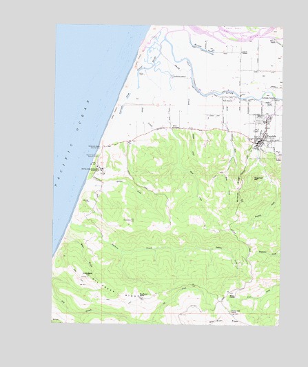
Ferndale, CA USGS Topographic Map
Click on map above to begin viewing in our Map Viewer.

This topographic map contains these locations and features:
Feature Name Type Latitude Longitude GNIS ID View Map
Arlynda CornersPopulated PlaceN40.5949°W124.2551°218372View Map
Bear GulchValleyN40.5360°W124.3673°218845View Map
Bear River RidgeRidgeN40.5010°W124.2828°218874View Map
Bunker Hill RanchLocaleN40.5046°W124.2778°220164View Map
Bunker Hill School (historical)SchoolN40.5399°W124.2787°1681873View Map
Bunker Hill School (historical)SchoolN40.5001°W124.2645°1665527View Map
Centerville (historical)Populated PlaceN40.5749°W124.3481°1681876View Map
Centerville BeachLocaleN40.5735°W124.3501°254732View Map
Centerville School (historical)SchoolN40.5810°W124.3223°1665530View Map
Centerville SloughGutN40.5918°W124.3373°220828View Map
Church of the AssumptionChurchN40.5765°W124.2614°1702118View Map
City of FerndaleCivilN40.5799°W124.2619°2410497View Map
Comisto Ranch (historical)LocaleN40.5099°W124.3589°1665533View Map
Congregational Church Independent-EvangelicalChurchN40.5787°W124.2612°1681882View Map
Cutoff SloughGutN40.6074°W124.3228°221945View Map
East Lake SloughGutN40.6204°W124.2892°1665535View Map
Eel River DeltaAreaN40.6165°W124.2845°1702452View Map
Ferindale Elementary SchoolSchoolN40.5777°W124.2673°1681884View Map
Ferindale High SchoolSchoolN40.5850°W124.2598°1681885View Map
Fern CottageLocaleN40.5821°W124.3109°223454View Map
Fern Cottage Historic DistrictParkN40.5818°W124.3114°1681883View Map
FerndalePopulated PlaceN40.5762°W124.2639°277513View Map
Ferndale CemeteryCemeteryN40.5729°W124.2620°1702119View Map
Ferndale Childrens CenterBuildingN40.5737°W124.2656°1702120View Map
Ferndale City HallBuildingN40.5804°W124.2601°1702121View Map
Ferndale Fire DepartmentBuildingN40.5760°W124.2636°2621890View Map
Ferndale MuseumBuildingN40.5782°W124.2634°1702122View Map
Ferndale Police DepartmentBuildingN40.5803°W124.2602°2751021View Map
Ferndale Post OfficePost OfficeN40.5777°W124.2628°1681886View Map
Ferndale Public LibraryBuildingN40.5796°W124.2612°1702123View Map
Ferndale Wastewater Treatment PlantLocaleN40.5936°W124.2606°2356912View Map
Firemens ParkParkN40.5732°W124.2653°1702124View Map
Fleener CreekStreamN40.5585°W124.3587°223593View Map
Francis CreekStreamN40.5943°W124.2634°223796View Map
Fulmor RanchLocaleN40.6196°W124.2578°223987View Map
Guthrie CreekStreamN40.5429°W124.3664°224749View Map
Humboldt County FairgroundsParkN40.5860°W124.2634°1681935View Map
Island SchoolSchoolN40.6140°W124.2737°226012View Map
KQEX-FM (Rohnerville)TowerN40.5007°W124.2873°1663032View Map
Little Bald HillSummitN40.5193°W124.3564°1656129View Map
Mayflower RanchLocaleN40.5110°W124.3276°228264View Map
Morgan SloughGutN40.6154°W124.2951°229056View Map
Naval Support Detachment MontereyMilitaryN40.5637°W124.3505°2511949View Map
Occidental RanchLocaleN40.6035°W124.3117°229918View Map
Oil Creek RidgeRidgeN40.5115°W124.3395°229949View Map
Our Saviors Lutheran ChurchChurchN40.5782°W124.2645°1681918View Map
Port KenyonPopulated PlaceN40.5951°W124.2798°230949View Map
Reas CreekStreamN40.5960°W124.2931°231305View Map
Russ CreekStreamN40.6004°W124.3206°232033View Map
Saint Marks Lutheran ChurchChurchN40.5790°W124.2601°1702126View Map
Saint Marys CemeteryCemeteryN40.5707°W124.2542°232213View Map
Sleepy HollowValleyN40.5110°W124.2739°233267View Map
Smith CreekStreamN40.6187°W124.3162°233321View Map
Sugarloaf MountainSummitN40.5612°W124.2664°235670View Map
Wildcat RidgeRidgeN40.5571°W124.2734°237805View Map
Woodland Echo Ranch (historical)LocaleN40.5143°W124.3520°1665557View Map
Wreck of Northerner Historical MarkParkN40.5701°W124.3517°1654527View Map

Note: Coordinates in the location and feature list above are referenced to NAD83 datum.


Copyright (C) 2008-2024 Ryan Niemi / Sunset Dynamics ... All Rights Reserved