TopoQuest Logo
Do you find TopoQuest useful?
Help keep TopoQuest running and adding new maps/features by donating!
Bitcoin:  19c7KJd3qBynnjoSw5npx9KScwjBe4ifkT
Litecoin:  LXs6TkuXGGXo1vDsWCkWVdjQX94eUKd6ui
Home View Maps Find Maps Find Places Resources & Links


Fertile, Minnesota Topographic Map

USGS Map Title: Fertile, MN
USGS Map MRC: 47096E3
DRG (GeoTIFF) Download: o47096e3.tif


Neighboring USGS Topographic Map Quads:


  Harold, MN  
47096F4
 

  Dugdale, MN  
47096F3
 

  Mentor, MN  
47096F2
 

  Melvin, MN  
47096E4
 

  Fertile, MN  
47096E3
 

  Halverson Lake, MN  
47096E2
 

  Twin Valley NW, MN  
47096D4
 

  Flaming, MN  
47096D3
 

  Ranum, MN  
47096D2


Map MRC Location:

N48°
W97°
N48°
W96°
H8 H7 H6 H5 H4 H3 H2 H1
G8 G7 G6 G5 G4 G3 G2 G1
F8 F7 F6 F5 F4 F3 F2 F1
E8 E7 E6 E5 E4 E3 E2 E1
D8 D7 D6 D5 D4 D3 D2 D1
C8 C7 C6 C5 C4 C3 C2 C1
B8 B7 B6 B5 B4 B3 B2 B1
A8 A7 A6 A5 A4 A3 A2 A1
N47°
W97°
N47°
W96°

Fertile, MN USGS 1:24K Topographic Map Preview:
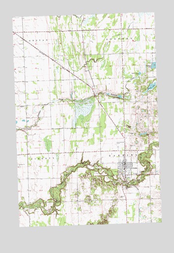
Fertile, MN USGS Topographic Map
Click on map above to begin viewing in our Map Viewer.

This topographic map contains these locations and features:
Feature Name Type Latitude Longitude GNIS ID View Map
Cheese Brown LakeLakeN47.5885°W96.2649°641136View Map
City of FertileCivilN47.5343°W96.2816°2394761View Map
Concordia CemeteryCemeteryN47.5218°W96.2818°649553View Map
Concordia East CemeteryCemeteryN47.5290°W96.2690°641435View Map
Concordia Lutheran ChurchChurchN47.5333°W96.2806°2081492View Map
County Emergency Medical ServicesBuildingN47.5370°W96.2802°2721244View Map
Fair Meadow Nursing HomeHospitalN47.5286°W96.2758°2081482View Map
FertilePopulated PlaceN47.5361°W96.2803°643615View Map
Fertile (historical)LocaleN47.5353°W96.2822°2081662View Map
Fertile Fire DepartmentBuildingN47.5338°W96.2796°2666424View Map
Fertile Golf CourseLocaleN47.5361°W96.2800°2081488View Map
Fertile Municipal AirportAirportN47.5469°W96.2896°660163View Map
Fertile Police DepartmentBuildingN47.5338°W96.2802°2081486View Map
Fertile Post OfficePost OfficeN47.5350°W96.2758°2081487View Map
Fertile-Beltrami High SchoolSchoolN47.5325°W96.2808°2081661View Map
First Evanger Lutheran ChurchChurchN47.5364°W96.2758°2081493View Map
Hagen's Mobile Home ParkPopulated PlaceN47.5361°W96.2800°2081489View Map
Hope Evangelical Free ChurchChurchN47.5347°W96.2797°2081494View Map
Jehovah's Witnesses CongregationChurchN47.5375°W96.2781°2081495View Map
Kurass LakeLakeN47.5806°W96.2553°646278View Map
Little Andrew LakeLakeN47.5756°W96.2829°646744View Map
Polk County Library - FertileBuildingN47.5361°W96.2800°2081485View Map
Saint John's Lutheran ChurchChurchN47.5361°W96.2800°2081490View Map
Saint Joseph Catholic CemeteryCemeteryN47.5298°W96.2690°650774View Map
Saint Joseph's Catholic ChurchChurchN47.5325°W96.2750°2081491View Map
Sand Hill River DamDamN47.5350°W96.3137°1776279View Map
Sand Hill River ReservoirReservoirN47.5350°W96.3137°1776280View Map
Township of GarfieldCivilN47.5435°W96.2572°664246View Map
Varnes ChurchChurchN47.5714°W96.3701°653621View Map
Varnes Lutheran CemeteryCemeteryN47.5717°W96.3702°2081300View Map

Note: Coordinates in the location and feature list above are referenced to NAD83 datum.


Copyright (C) 2008-2024 Ryan Niemi / Sunset Dynamics ... All Rights Reserved