TopoQuest Logo
Do you find TopoQuest useful?
Help keep TopoQuest running and adding new maps/features by donating!
Bitcoin:  19c7KJd3qBynnjoSw5npx9KScwjBe4ifkT
Litecoin:  LXs6TkuXGGXo1vDsWCkWVdjQX94eUKd6ui
Home View Maps Find Maps Find Places Resources & Links


Mentor, Minnesota Topographic Map

USGS Map Title: Mentor, MN
USGS Map MRC: 47096F2
DRG (GeoTIFF) Download: o47096f2.tif


Neighboring USGS Topographic Map Quads:


  Marcoux Corners, MN  
47096G3
 

  Terrebonne, MN  
47096G2
 

  Brooks, MN  
47096G1
 

  Dugdale, MN  
47096F3
 

  Mentor, MN  
47096F2
 

  Erskine, MN  
47096F1
 

  Fertile, MN  
47096E3
 

  Halverson Lake, MN  
47096E2
 

  Union Lake, MN  
47096E1


Map MRC Location:

N48°
W97°
N48°
W96°
H8 H7 H6 H5 H4 H3 H2 H1
G8 G7 G6 G5 G4 G3 G2 G1
F8 F7 F6 F5 F4 F3 F2 F1
E8 E7 E6 E5 E4 E3 E2 E1
D8 D7 D6 D5 D4 D3 D2 D1
C8 C7 C6 C5 C4 C3 C2 C1
B8 B7 B6 B5 B4 B3 B2 B1
A8 A7 A6 A5 A4 A3 A2 A1
N47°
W97°
N47°
W96°

Mentor, MN USGS 1:24K Topographic Map Preview:
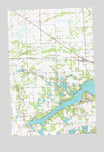
Mentor, MN USGS Topographic Map
Click on map above to begin viewing in our Map Viewer.

This topographic map contains these locations and features:
Feature Name Type Latitude Longitude GNIS ID View Map
Bakken LakeLakeN47.6901°W96.2309°639590View Map
Birch LakeLakeN47.6274°W96.1608°640176View Map
Braaten LakeLakeN47.6292°W96.1421°640409View Map
Cable LakeLakeN47.6731°W96.1728°640727View Map
City of MentorCivilN47.6965°W96.1440°2395100View Map
County Ditch Number FourteenCanalN47.7155°W96.1506°641683View Map
County Ditch Number SixtyfiveCanalN47.6450°W96.2484°642258View Map
Faith Lutheran CemeteryCemeteryN47.7053°W96.1366°643534View Map
Faith Lutheran ChurchChurchN47.6983°W96.1408°2081829View Map
First English Lutheran CemeteryCemeteryN47.6845°W96.1477°2081313View Map
Hitterdal CemeteryCemeteryN47.6894°W96.2178°645033View Map
Judicial Ditch Number SixtyfourCanalN47.7233°W96.2023°645966View Map
Lakeside CemeteryCemeteryN47.6789°W96.1479°2081314View Map
Maple BayPopulated PlaceN47.6358°W96.2251°647462View Map
Maple Bay CemeteryCemeteryN47.6468°W96.2369°2081316View Map
Maple Bay Free ChurchChurchN47.6333°W96.2253°2081830View Map
Maple Bay Free Lutheran CemeteryCemeteryN47.6337°W96.2156°2081315View Map
Maple LakeLakeN47.6592°W96.1598°647490View Map
Maplebay Post Office (historical)Post OfficeN47.6358°W96.2247°2081416View Map
MentorPopulated PlaceN47.6983°W96.1412°647772View Map
MentorLocaleN47.6972°W96.1417°2081815View Map
Mentor Post OfficePost OfficeN47.6983°W96.1408°2081826View Map
Mentor Volunteer Fire and RescueBuildingN47.7009°W96.1437°2081828View Map
Rosehill CemeteryCemeteryN47.7041°W96.1812°650284View Map
Saint Lawrence Catholic CemeteryCemeteryN47.7045°W96.1367°650788View Map
Saint Lawrence Catholic ChurchChurchN47.6983°W96.1408°2081827View Map
Tilden State Wildlife Management AreaParkN47.6891°W96.2348°653203View Map
Township of Grove Park (historical)CivilN47.7072°W96.1700°664361View Map
Township of Grove Park-TildenCivilN47.7169°W96.2257°1729757View Map
Township of WoodsideCivilN47.6293°W96.1311°666048View Map

Note: Coordinates in the location and feature list above are referenced to NAD83 datum.


Copyright (C) 2008-2025 Ryan Niemi / Sunset Dynamics ... All Rights Reserved