TopoQuest Logo
Do you find TopoQuest useful?
Help keep TopoQuest running and adding new maps/features by donating!
Bitcoin:  19c7KJd3qBynnjoSw5npx9KScwjBe4ifkT
Litecoin:  LXs6TkuXGGXo1vDsWCkWVdjQX94eUKd6ui
Home View Maps Find Maps Find Places Resources & Links


Fidelis, Florida Topographic Map

USGS Map Title: Fidelis, FL
USGS Map MRC: 30087H1
DRG (GeoTIFF) Download: o30087h1.tif


Neighboring USGS Topographic Map Quads:


  Pollard, AL  
31087A2
 

  Brewton South, AL  
31087A1
 

  Roberts, AL  
31086A8
 

  Jay, FL  
30087H2
 

  Fidelis, FL  
30087H1
 

  McLellan, FL  
30086H8
 

  Chumuckla, FL  
30087G2
 

  Allentown, FL  
30087G1
 

  Spring Hill, FL  
30086G8


Map MRC Location:

N31°
W88°
N31°
W87°
H8 H7 H6 H5 H4 H3 H2 H1
G8 G7 G6 G5 G4 G3 G2 G1
F8 F7 F6 F5 F4 F3 F2 F1
E8 E7 E6 E5 E4 E3 E2 E1
D8 D7 D6 D5 D4 D3 D2 D1
C8 C7 C6 C5 C4 C3 C2 C1
B8 B7 B6 B5 B4 B3 B2 B1
A8 A7 A6 A5 A4 A3 A2 A1
N30°
W88°
N30°
W87°

Fidelis, FL USGS 1:24K Topographic Map Preview:
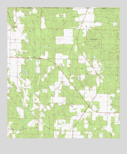
Fidelis, FL USGS Topographic Map
Click on map above to begin viewing in our Map Viewer.

This topographic map contains these locations and features:
Feature Name Type Latitude Longitude GNIS ID View Map
BerrydalePopulated PlaceN30.8994°W87.0139°294679View Map
Berrydale Census Designated PlaceCensusN30.8982°W87.0350°2583329View Map
Berrydale DivisionCivilN30.9090°W87.0223°2648021View Map
Berrydale Fire Department Station 14BuildingN30.9058°W87.0338°2644142View Map
Bishop BranchStreamN30.9638°W87.0072°278861View Map
Clear BranchStreamN30.9177°W87.0977°280522View Map
Cobb BranchStreamN30.8882°W87.1064°280594View Map
Cobb CreekStreamN30.9582°W87.0927°295207View Map
CobbtownPopulated PlaceN30.8830°W87.1197°294719View Map
Cobbtown Census Designated PlaceCensusN30.8823°W87.1212°2629312View Map
Crossroads CemeteryCemeteryN30.9041°W87.0352°301637View Map
Crossroads ChurchChurchN30.9055°W87.0361°301636View Map
DixonvillePopulated PlaceN30.9865°W87.0411°2652408View Map
Dixonville Census Designated PlaceCensusN30.9864°W87.0416°2629555View Map
Dixonville ChurchChurchN30.9863°W87.0458°281619View Map
Dry BranchStreamN30.9732°W87.0969°281786View Map
East Fork Juniper CreekStreamN30.9241°W87.0458°281975View Map
Ellis PondLakeN30.9315°W87.0447°282181View Map
FidelisPopulated PlaceN30.9363°W87.0241°294766View Map
Fidelis Census Designated PlaceCensusN30.9343°W87.0245°2629313View Map
Fidelis ChurchChurchN30.9424°W87.0294°282444View Map
Fidelis SchoolSchoolN30.9363°W87.0227°301635View Map
Golden Harvest Flying Service IncAirportN30.9061°W87.0436°309536View Map
Golden Memorial ChurchChurchN30.9799°W87.0514°283156View Map
James Thomas PondLakeN30.9529°W87.0281°298120View Map
Malloy BranchStreamN30.8994°W87.1041°286331View Map
Mount CarmelPopulated PlaceN30.9810°W87.1186°295466View Map
Mount Carmel Census Designated PlaceCensusN30.9868°W87.1210°2583366View Map
Old Fidelis CemeteryCemeteryN30.9418°W87.0405°288092View Map
Picnic LakeReservoirN30.9384°W87.1053°288787View Map
Pine Grove ChurchChurchN30.9071°W87.0105°288850View Map
Red BranchStreamN30.9913°W87.0886°125472View Map
Thomas Farms AirportAirportN30.9690°W87.0525°309531View Map
Travelers Rest ChurchChurchN30.8905°W87.0016°292407View Map
West Fork Juniper CreekStreamN30.9241°W87.0458°293065View Map
WhitfieldPopulated PlaceN30.8819°W87.0524°301643View Map
Whitfield Census Designated PlaceCensusN30.8787°W87.0613°2629316View Map
Whitfield ChurchChurchN30.8855°W87.0514°293250View Map

Note: Coordinates in the location and feature list above are referenced to NAD83 datum.


Copyright (C) 2008-2024 Ryan Niemi / Sunset Dynamics ... All Rights Reserved