TopoQuest Logo
Do you find TopoQuest useful?
Help keep TopoQuest running and adding new maps/features by donating!
Bitcoin:  19c7KJd3qBynnjoSw5npx9KScwjBe4ifkT
Litecoin:  LXs6TkuXGGXo1vDsWCkWVdjQX94eUKd6ui
Home View Maps Find Maps Find Places Resources & Links


Chumuckla, Florida Topographic Map

USGS Map Title: Chumuckla, FL
USGS Map MRC: 30087G2
DRG (GeoTIFF) Download: o30087g2.tif


Neighboring USGS Topographic Map Quads:


  Century, FL  
30087H3
 

  Jay, FL  
30087H2
 

  Fidelis, FL  
30087H1
 

  McDavid, FL  
30087G3
 

  Chumuckla, FL  
30087G2
 

  Allentown, FL  
30087G1
 

  Molino, FL  
30087F3
 

  Wallace, FL  
30087F2
 

  Milton North, FL  
30087F1


Map MRC Location:

N31°
W88°
N31°
W87°
H8 H7 H6 H5 H4 H3 H2 H1
G8 G7 G6 G5 G4 G3 G2 G1
F8 F7 F6 F5 F4 F3 F2 F1
E8 E7 E6 E5 E4 E3 E2 E1
D8 D7 D6 D5 D4 D3 D2 D1
C8 C7 C6 C5 C4 C3 C2 C1
B8 B7 B6 B5 B4 B3 B2 B1
A8 A7 A6 A5 A4 A3 A2 A1
N30°
W88°
N30°
W87°

Chumuckla, FL USGS 1:24K Topographic Map Preview:
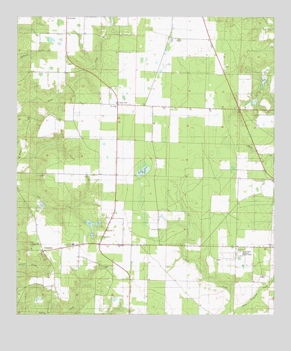
Chumuckla, FL USGS Topographic Map
Click on map above to begin viewing in our Map Viewer.

This topographic map contains these locations and features:
Feature Name Type Latitude Longitude GNIS ID View Map
Allentown DivisionCivilN30.7772°W87.1666°2648018View Map
Allentown Volunteer Fire Department Substation 11BuildingN30.7728°W87.2049°2644213View Map
Ard-Field ChurchChurchN30.7860°W87.1811°277942View Map
ChumucklaPopulated PlaceN30.7766°W87.2372°294714View Map
Chumuckla 20-20 AirportAirportN30.7514°W87.1781°309698View Map
Chumuckla CemeteryCemeteryN30.7796°W87.2430°280444View Map
Chumuckla Census Designated PlaceCensusN30.7826°W87.2310°2583335View Map
Chumuckla ChurchChurchN30.7830°W87.2086°280445View Map
Chumuckla SchoolSchoolN30.7796°W87.2230°280446View Map
Forty Acre PondLakeN30.8107°W87.1884°282720View Map
John C Pace Pond OneLakeN30.7879°W87.2144°298121View Map
John C Pace Pond TwoLakeN30.7833°W87.2134°298122View Map
New Bethel ChurchChurchN30.8380°W87.2016°287603View Map
New Hope ChurchChurchN30.7855°W87.2064°287643View Map
New YorkPopulated PlaceN30.8385°W87.2008°294865View Map
Odom's Flying ServiceAirportN30.8527°W87.2393°309535View Map
University of Florida Agricultural Research CenterLocaleN30.7766°W87.1414°292688View Map
W B Jordon PondLakeN30.8410°W87.1625°298125View Map
Wells Flying ServiceAirportN30.8647°W87.1772°309533View Map

Note: Coordinates in the location and feature list above are referenced to NAD83 datum.


Copyright (C) 2008-2025 Ryan Niemi / Sunset Dynamics ... All Rights Reserved