TopoQuest Logo
Do you find TopoQuest useful?
Help keep TopoQuest running and adding new maps/features by donating!
Bitcoin:  19c7KJd3qBynnjoSw5npx9KScwjBe4ifkT
Litecoin:  LXs6TkuXGGXo1vDsWCkWVdjQX94eUKd6ui
Home View Maps Find Maps Find Places Resources & Links


Fine Creek Mills, Virginia Topographic Map

USGS Map Title: Fine Creek Mills, VA
USGS Map MRC: 37077E7
DRG (GeoTIFF) Download: o37077e7.tif


Neighboring USGS Topographic Map Quads:


  Goochland, VA  
37077F8
 

  Perkinsville, VA  
37077F7
 

  Hylas, VA  
37077F6
 

  Powhatan, VA  
37077E8
 

  Fine Creek Mills, VA  
37077E7
 

  Midlothian, VA  
37077E6
 

  Chula, VA  
37077D8
 

  Clayville, VA  
37077D7
 

  Hallsboro, VA  
37077D6


Map MRC Location:

N38°
W78°
N38°
W77°
H8 H7 H6 H5 H4 H3 H2 H1
G8 G7 G6 G5 G4 G3 G2 G1
F8 F7 F6 F5 F4 F3 F2 F1
E8 E7 E6 E5 E4 E3 E2 E1
D8 D7 D6 D5 D4 D3 D2 D1
C8 C7 C6 C5 C4 C3 C2 C1
B8 B7 B6 B5 B4 B3 B2 B1
A8 A7 A6 A5 A4 A3 A2 A1
N37°
W78°
N37°
W77°

Fine Creek Mills, VA USGS 1:24K Topographic Map Preview:
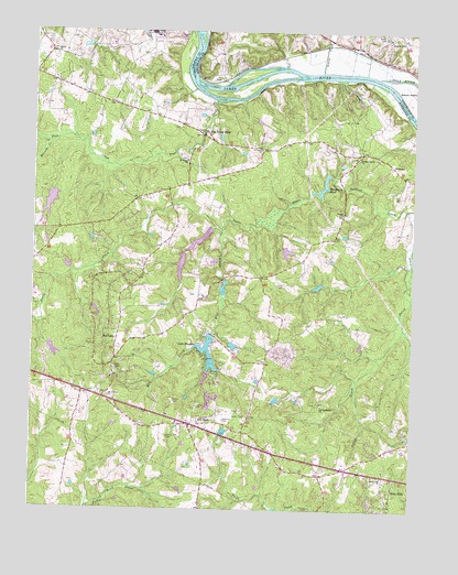
Fine Creek Mills, VA USGS Topographic Map
Click on map above to begin viewing in our Map Viewer.

This topographic map contains these locations and features:
Feature Name Type Latitude Longitude GNIS ID View Map
Branch CreekStreamN37.5957°W77.8697°1463754View Map
Byers DamDamN37.5818°W77.8681°1490627View Map
Byers Mill DamDamN37.5601°W77.8114°1490629View Map
Byers MillpondReservoirN37.5579°W77.8122°1490630View Map
Byers PondReservoirN37.5801°W77.8695°1490628View Map
Chestnut OaksPopulated PlaceN37.5410°W77.7922°1674215View Map
Corinth ChurchChurchN37.5776°W77.7733°1465257View Map
Deep Meadow Correctional CenterBuildingN37.6218°W77.8495°2741359View Map
Deerfield SchoolSchoolN37.5461°W77.8333°2465505View Map
District 1CivilN37.5573°W77.7615°1927189View Map
Fine CreekStreamN37.6065°W77.8153°1466561View Map
Fine Creek MillsPopulated PlaceN37.5979°W77.8192°1466563View Map
Flat RockPopulated PlaceN37.5226°W77.8233°1494927View Map
Flatrock Air Strip (historical)AirportN37.5232°W77.8194°1498799View Map
Genito CreekStreamN37.6146°W77.7808°1467031View Map
Holly HillsPopulated PlaceN37.5057°W77.7561°1494994View Map
Jones CreekStreamN37.5829°W77.7836°1468838View Map
Krouses MillLocaleN37.5604°W77.8131°1674221View Map
Lake ShawneeReservoirN37.5428°W77.8175°1474459View Map
Lake Shawnee DamDamN37.5451°W77.8164°1490623View Map
LeePopulated PlaceN37.6115°W77.8164°1495024View Map
LilburnPopulated PlaceN37.5218°W77.8394°1674222View Map
Lower Byers DamDamN37.5718°W77.8164°1490619View Map
Lower Byers LakeReservoirN37.5707°W77.8199°1490620View Map
Mill CreekStreamN37.5732°W77.8131°1470489View Map
Mount Calvary ChurchChurchN37.5296°W77.8494°1470828View Map
Old Powhatan ChurchChurchN37.5274°W77.7797°1471865View Map
Pleasant GreenPopulated PlaceN37.6190°W77.8133°1674319View Map
Pleasant Grove Baptist ChurchChurchN37.5921°W77.7686°1472483View Map
Powhatan County Fire Department Company 2 - Huguenot Volunteer Fire DepartmentBuildingN37.5092°W77.7785°2086088View Map
Powhatan County Fire Department Company 4 - Fine Creek Volunteer Fire DepartmentBuildingN37.5923°W77.7692°2086090View Map
Powhatan County Volunteer Rescue Squad Substation 1BuildingN37.5936°W77.7683°2086085View Map
Powhatan High SchoolSchoolN37.5221°W77.8025°1674227View Map
Powhatan Vocational Center SchoolSchoolN37.5222°W77.8027°2465080View Map
Red LanePopulated PlaceN37.5468°W77.8494°1495106View Map
Red Lane Baptist ChurchChurchN37.5343°W77.8486°1674228View Map
Rocky Oak CemeteryCemeteryN37.5190°W77.8297°1473478View Map
Rocky Oak ChurchChurchN37.5088°W77.7594°1473479View Map
Rossons DamDamN37.5301°W77.7931°1490640View Map
Sabot HillSummitN37.6235°W77.7589°1495116View Map
Saint James ChurchChurchN37.5913°W77.8247°1473737View Map
Saint Lukes CemeteryCemeteryN37.5942°W77.8002°1674229View Map
Saint Lukes ChurchChurchN37.5943°W77.8003°1473807View Map
Shawnee Lot Owners DamDamN37.5368°W77.8197°1490641View Map
Shiloh ChurchChurchN37.6199°W77.8689°1474515View Map
Southern Service Corporation DamDamN37.5435°W77.8697°1490643View Map
Spratley-Leigh DamDamN37.5668°W77.7931°1490645View Map
Spring Valley AirportAirportN37.5966°W77.8001°1498775View Map
Subletts CemeteryCemeteryN37.5590°W77.7925°1475276View Map
Subletts School (historical)SchoolN37.5918°W77.7617°1674230View Map
Upper Byers DamDamN37.5668°W77.8247°1490617View Map
Upper Byers LakeReservoirN37.5638°W77.8262°1490618View Map
Virginia State Police Division 1 Area 6 OfficeBuildingN37.5109°W77.7755°2332133View Map
Vranian DamDamN37.5635°W77.8614°1490644View Map
Walkers DamDamN37.5435°W77.8097°1490642View Map
Watkins CemeteryCemeteryN37.5235°W77.8117°1476383View Map
Woodberry DamDamN37.5874°W77.7772°1490621View Map
Woodberry PondReservoirN37.5834°W77.7805°1490622View Map

Note: Coordinates in the location and feature list above are referenced to NAD83 datum.


Copyright (C) 2008-2024 Ryan Niemi / Sunset Dynamics ... All Rights Reserved