TopoQuest Logo
Do you find TopoQuest useful?
Help keep TopoQuest running and adding new maps/features by donating!
Bitcoin:  19c7KJd3qBynnjoSw5npx9KScwjBe4ifkT
Litecoin:  LXs6TkuXGGXo1vDsWCkWVdjQX94eUKd6ui
Home View Maps Find Maps Find Places Resources & Links


Chula, Virginia Topographic Map

USGS Map Title: Chula, VA
USGS Map MRC: 37077D8
DRG (GeoTIFF) Download: o37077d8.tif


Neighboring USGS Topographic Map Quads:


  Trenholm, VA  
37078E1
 

  Powhatan, VA  
37077E8
 

  Fine Creek Mills, VA  
37077E7
 

  Ballsville, VA  
37078D1
 

  Chula, VA  
37077D8
 

  Clayville, VA  
37077D7
 

  Jetersville, VA  
37078C1
 

  Amelia Court House, VA  
37077C8
 

  Mannboro, VA  
37077C7


Map MRC Location:

N38°
W78°
N38°
W77°
H8 H7 H6 H5 H4 H3 H2 H1
G8 G7 G6 G5 G4 G3 G2 G1
F8 F7 F6 F5 F4 F3 F2 F1
E8 E7 E6 E5 E4 E3 E2 E1
D8 D7 D6 D5 D4 D3 D2 D1
C8 C7 C6 C5 C4 C3 C2 C1
B8 B7 B6 B5 B4 B3 B2 B1
A8 A7 A6 A5 A4 A3 A2 A1
N37°
W78°
N37°
W77°

Chula, VA USGS 1:24K Topographic Map Preview:
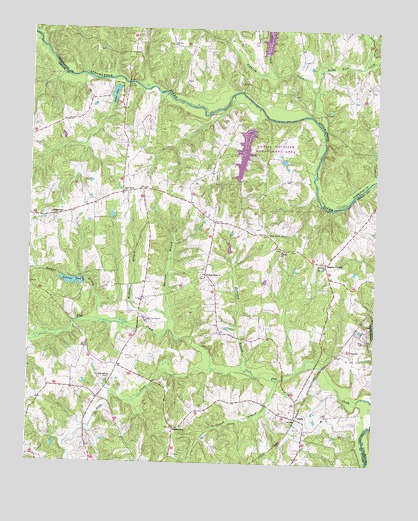
Chula, VA USGS Topographic Map
Click on map above to begin viewing in our Map Viewer.

This topographic map contains these locations and features:
Feature Name Type Latitude Longitude GNIS ID View Map
Amelia Ambulance ServiceBuildingN37.3922°W77.9844°2721100View Map
Amelia County Volunteer Fire DepartmentBuildingN37.4326°W77.8933°2331900View Map
Amelia County Volunteer Fire Department Company 4 MattoaxBuildingN37.4327°W77.8933°2331895View Map
Amelia DamDamN37.4717°W77.9206°1489110View Map
Amelia LakeReservoirN37.4652°W77.9228°1489111View Map
Amella Wildlife Management AreaParkN37.4643°W77.9139°1462441View Map
Anderson PondReservoirN37.4272°W77.9844°1462466View Map
Andersons DamDamN37.4268°W77.9806°1489112View Map
Barkhouse BranchStreamN37.3990°W77.9103°1462792View Map
Brick Church SchoolSchoolN37.4413°W77.9133°1463800View Map
ChulaPopulated PlaceN37.3885°W77.9031°1492767View Map
CoverlyPopulated PlaceN37.4068°W77.8833°1492812View Map
District 2CivilN37.4295°W77.9728°1927197View Map
Dutch Reformed CemeteryCemeteryN37.4318°W77.8969°1497782View Map
Elk HillSummitN37.4507°W77.9519°1690036View Map
FieldstownPopulated PlaceN37.3854°W77.9472°1477322View Map
Fighting CreekStreamN37.4821°W77.8975°1466556View Map
Giles BridgeBridgeN37.4843°W77.9653°1467082View Map
Giles MillPopulated PlaceN37.4821°W77.9675°1497786View Map
Grub Hill CemeteryCemeteryN37.3996°W77.9700°1497789View Map
Grub Hill ChurchChurchN37.3999°W77.9703°1467577View Map
Hill Top Airport (historical)AirportN37.4157°W77.9550°1498577View Map
Horsepen BranchStreamN37.4004°W77.9178°1468280View Map
Jones LakeReservoirN37.4810°W77.9701°1468846View Map
Liberty ChurchChurchN37.4365°W77.9083°1469364View Map
Masons CornerPopulated PlaceN37.4329°W77.8928°1493257View Map
Mattoax ChurchChurchN37.4315°W77.8928°1470198View Map
Mattoax Company 4BuildingN37.4492°W77.8750°2075597View Map
Myrtlene BranchStreamN37.4179°W77.9500°1471303View Map
Neds CreekStreamN37.4868°W77.9114°1471359View Map
Nibbs CreekStreamN37.4024°W77.9333°1471533View Map
Oakmulgee DairyLocaleN37.4794°W77.9792°2675260View Map
Pilgrim Mennonite SchoolSchoolN37.4465°W77.9919°1472310View Map
Pine Grove CemeteryCemeteryN37.4529°W77.9669°1497804View Map
Pine Grove ChurchChurchN37.4529°W77.9664°1472347View Map
Pleasant Grove Baptist ChurchChurchN37.4285°W77.9361°1472481View Map
Pleasant Grove CemeteryCemeteryN37.4288°W77.9372°1497805View Map
Rocky Ford CreekStreamN37.4724°W77.8950°1474273View Map
Sunders DamDamN37.4618°W77.9081°1489128View Map
Walker BranchStreamN37.4165°W77.9750°1476233View Map
Whittington DamDamN37.4351°W77.9281°1489129View Map
Wildcat BranchStreamN37.4135°W77.9494°1476713View Map

Note: Coordinates in the location and feature list above are referenced to NAD83 datum.


Copyright (C) 2008-2025 Ryan Niemi / Sunset Dynamics ... All Rights Reserved