TopoQuest Logo
Do you find TopoQuest useful?
Help keep TopoQuest running and adding new maps/features by donating!
Bitcoin:  19c7KJd3qBynnjoSw5npx9KScwjBe4ifkT
Litecoin:  LXs6TkuXGGXo1vDsWCkWVdjQX94eUKd6ui
Home View Maps Find Maps Find Places Resources & Links


Finlayson, Minnesota Topographic Map

USGS Map Title: Finlayson, MN
USGS Map MRC: 46092B8
DRG (GeoTIFF) Download: o46092b8.tif


Neighboring USGS Topographic Map Quads:


  Arthyde, MN  
46093C1
 

  Denham, MN  
46092C8
 

  Willow River, MN  
46092C7
 

  Giese, MN  
46093B1
 

  Finlayson, MN  
46092B8
 

  Sandstone North, MN  
46092B7
 

  Kroschel, MN  
46093A1
 

  Hinckley, MN  
46092A8
 

  Sandstone South, MN  
46092A7


Map MRC Location:

N47°
W93°
N47°
W92°
H8 H7 H6 H5 H4 H3 H2 H1
G8 G7 G6 G5 G4 G3 G2 G1
F8 F7 F6 F5 F4 F3 F2 F1
E8 E7 E6 E5 E4 E3 E2 E1
D8 D7 D6 D5 D4 D3 D2 D1
C8 C7 C6 C5 C4 C3 C2 C1
B8 B7 B6 B5 B4 B3 B2 B1
A8 A7 A6 A5 A4 A3 A2 A1
N46°
W93°
N46°
W92°

Finlayson, MN USGS 1:24K Topographic Map Preview:
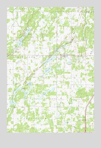
Finlayson, MN USGS Topographic Map
Click on map above to begin viewing in our Map Viewer.

This topographic map contains these locations and features:
Feature Name Type Latitude Longitude GNIS ID View Map
Bass LakeLakeN46.2274°W92.9687°639681View Map
Charlie Bear LakeLakeN46.1668°W92.9771°1815048View Map
City of FinlaysonCivilN46.2051°W92.9248°2394766View Map
Clear LakeLakeN46.2071°W92.9299°1815054View Map
Elbow LakeLakeN46.1659°W92.9881°643224View Map
FinlaysonPopulated PlaceN46.2016°W92.9160°643633View Map
Finlayson (historical)LocaleN46.2006°W92.9161°2070013View Map
Finlayson City HallBuildingN46.2014°W92.9175°2070019View Map
Finlayson Elementary SchoolSchoolN46.2017°W92.9217°2070018View Map
Finlayson Fire DepartmentBuildingN46.2007°W92.9175°2070020View Map
Finlayson Post OfficePost OfficeN46.2017°W92.9158°2070014View Map
Finlayson United Methodist ChurchChurchN46.2025°W92.9181°2070017View Map
Finnish CemeteryCemeteryN46.1985°W92.9274°1815052View Map
Fish LakeLakeN46.1974°W92.9388°643687View Map
Grass LakeLakeN46.1650°W92.9725°644375View Map
GroningenPopulated PlaceN46.1508°W92.9241°644490View Map
Hellmans LakeLakeN46.1740°W92.9682°1815049View Map
Immanuel Lutheran ChurchChurchN46.2017°W92.9158°2070015View Map
Indian LakeLakeN46.1871°W92.9412°645412View Map
Interchange 191CrossingN46.1253°W92.8872°2070057View Map
Koivisto SchoolSchoolN46.2024°W92.9605°646228View Map
Little Bass LakeLakeN46.2230°W92.9723°646749View Map
Little Pine CreekStreamN46.2361°W92.9869°646884View Map
Little Pine LakeLakeN46.2157°W92.9803°646886View Map
Medicine CreekStreamN46.2486°W92.8830°1815055View Map
Miller LakeLakeN46.1662°W92.9424°647873View Map
Mud LakeLakeN46.2065°W92.9266°648287View Map
Peace Lutheran ChurchChurchN46.2025°W92.9203°2070016View Map
Peace Lutheran ChurchChurchN46.1986°W92.9278°2069872View Map
Rhine CreekStreamN46.2483°W92.9866°649958View Map
Saint Johns ChurchChurchN46.2002°W92.9288°1815053View Map
Skunk LakeLakeN46.1350°W92.9161°1815051View Map
Township of Pine LakeCivilN46.2018°W92.9929°665308View Map

Note: Coordinates in the location and feature list above are referenced to NAD83 datum.


Copyright (C) 2008-2025 Ryan Niemi / Sunset Dynamics ... All Rights Reserved