TopoQuest Logo
Do you find TopoQuest useful?
Help keep TopoQuest running and adding new maps/features by donating!
Bitcoin:  19c7KJd3qBynnjoSw5npx9KScwjBe4ifkT
Litecoin:  LXs6TkuXGGXo1vDsWCkWVdjQX94eUKd6ui
Home View Maps Find Maps Find Places Resources & Links


Hinckley, Minnesota Topographic Map

USGS Map Title: Hinckley, MN
USGS Map MRC: 46092A8
DRG (GeoTIFF) Download: o46092a8.tif


Neighboring USGS Topographic Map Quads:


  Giese, MN  
46093B1
 

  Finlayson, MN  
46092B8
 

  Sandstone North, MN  
46092B7
 

  Kroschel, MN  
46093A1
 

  Hinckley, MN  
46092A8
 

  Sandstone South, MN  
46092A7
 

  Brook Park, MN  
45093H1
 

  Beroun, MN  
45092H8
 

  Cedar Lake, MN  
45092H7


Map MRC Location:

N47°
W93°
N47°
W92°
H8 H7 H6 H5 H4 H3 H2 H1
G8 G7 G6 G5 G4 G3 G2 G1
F8 F7 F6 F5 F4 F3 F2 F1
E8 E7 E6 E5 E4 E3 E2 E1
D8 D7 D6 D5 D4 D3 D2 D1
C8 C7 C6 C5 C4 C3 C2 C1
B8 B7 B6 B5 B4 B3 B2 B1
A8 A7 A6 A5 A4 A3 A2 A1
N46°
W93°
N46°
W92°

Hinckley, MN USGS 1:24K Topographic Map Preview:
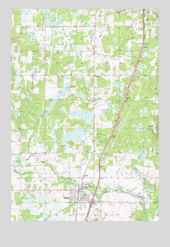
Hinckley, MN USGS Topographic Map
Click on map above to begin viewing in our Map Viewer.

This topographic map contains these locations and features:
Feature Name Type Latitude Longitude GNIS ID View Map
Bush FieldAirportN46.0379°W92.9883°2676849View Map
Caboose ParkParkN46.0114°W92.9442°2070006View Map
City of HinckleyCivilN46.0121°W92.9259°2394390View Map
Dell Grove CemeteryCemeteryN46.1142°W92.9754°2069858View Map
Dell Grove ChurchChurchN46.1141°W92.9752°642756View Map
Evergreen Memorial ParkCemeteryN46.0856°W92.9582°2069854View Map
Evergreen Memorial ParkParkN46.0852°W92.9583°643472View Map
Evergreen ParkPopulated PlaceN46.0114°W92.9442°2069992View Map
Faith Baptist ChurchChurchN46.0128°W92.9322°2069986View Map
Field of Dreams AirportAirportN46.0233°W92.8964°2676809View Map
First Lutheran ChurchChurchN46.0122°W92.9414°2069983View Map
First Presbyterian ChurchChurchN46.0114°W92.9442°2069989View Map
FirstLight Health System Hinckley ClinicBuildingN46.0099°W92.9234°2069995View Map
FrieslandPopulated PlaceN46.0855°W92.9296°643962View Map
Friesland DitchCanalN46.0911°W92.8969°1815040View Map
Grand Casino Hinckley RV ParkLocaleN46.0106°W92.8972°2069993View Map
Grand National Golf ClubLocaleN46.0056°W92.9167°2069996View Map
Grindstone River DamDamN46.0200°W92.9435°1776737View Map
HinckleyLocaleN46.0150°W92.9389°2069980View Map
HinckleyPopulated PlaceN46.0113°W92.9444°645028View Map
Hinckley Bible Baptist ChurchChurchN46.0181°W92.9403°2069981View Map
Hinckley City HallBuildingN46.0142°W92.9403°2070002View Map
Hinckley Elementary SchoolSchoolN46.0139°W92.9350°2070000View Map
Hinckley Evangelical Free ChurchChurchN46.0106°W92.9367°2069984View Map
Hinckley Finlayson High SchoolSchoolN46.0161°W92.9400°2069999View Map
Hinckley Fire Historical MarkerParkN46.0222°W92.9428°2070008View Map
Hinckley Fire State MonumentParkN46.0111°W92.9225°2070007View Map
Hinckley Post OfficePost OfficeN46.0153°W92.9400°2069998View Map
Hinckley Public LibraryBuildingN46.0142°W92.9403°2070001View Map
Hinckley Seventh Day Adventist ChurchChurchN46.0131°W92.9361°2069985View Map
Hinckley Volunteer Fire DepartmentBuildingN46.0144°W92.9420°2069997View Map
Interchange 183CrossingN46.0111°W92.9319°2070058View Map
Legion ParkParkN46.0189°W92.9397°2070003View Map
Lutheran Memorial CemeteryCemeteryN46.0115°W92.9236°2069991View Map
Memorial ParkParkN46.0139°W92.9381°2070005View Map
North Branch Grindstone RiverStreamN46.0219°W92.9455°648613View Map
Pine Medical Ambulance Service HinckleyBuildingN46.0173°W92.9386°2721392View Map
Rose Hill CemeteryCemeteryN46.0101°W92.9283°650266View Map
Saint Patrick's Catholic ChurchChurchN46.0133°W92.9414°2069982View Map
Saint Paul Lutheran ChurchChurchN46.0189°W92.9514°2069987View Map
Sandstone Municipal Airport (historical)AirportN46.1163°W92.8835°660407View Map
Skunk LakeLakeN46.1027°W92.9291°1815042View Map
South Branch Grindstone RiverStreamN46.0222°W92.9455°658355View Map
Township of Dell GroveCivilN46.1149°W92.9811°663961View Map
Township of HinckleyCivilN46.0272°W92.9951°664484View Map
West Side ParkParkN46.0144°W92.9444°2070004View Map
Workman Landing Strip (historical)AirportN46.0550°W92.8791°1815041View Map
Zeman Airport (historical)AirportN46.0205°W92.9905°660217View Map
Zion Lutheran ChurchChurchN46.0114°W92.9442°2069988View Map

Note: Coordinates in the location and feature list above are referenced to NAD83 datum.


Copyright (C) 2008-2025 Ryan Niemi / Sunset Dynamics ... All Rights Reserved