TopoQuest Logo
Do you find TopoQuest useful?
Help keep TopoQuest running and adding new maps/features by donating!
Bitcoin:  19c7KJd3qBynnjoSw5npx9KScwjBe4ifkT
Litecoin:  LXs6TkuXGGXo1vDsWCkWVdjQX94eUKd6ui
Home View Maps Find Maps Find Places Resources & Links


Sandstone North, Minnesota Topographic Map

USGS Map Title: Sandstone North, MN
USGS Map MRC: 46092B7
DRG (GeoTIFF) Download: o46092b7.tif


Neighboring USGS Topographic Map Quads:


  Denham, MN  
46092C8
 

  Willow River, MN  
46092C7
 

  Bruno, MN  
46092C6
 

  Finlayson, MN  
46092B8
 

  Sandstone North, MN  
46092B7
 

  Askov Lookout Tower, MN  
46092B6
 

  Hinckley, MN  
46092A8
 

  Sandstone South, MN  
46092A7
 

  Cloverdale, MN  
46092A6


Map MRC Location:

N47°
W93°
N47°
W92°
H8 H7 H6 H5 H4 H3 H2 H1
G8 G7 G6 G5 G4 G3 G2 G1
F8 F7 F6 F5 F4 F3 F2 F1
E8 E7 E6 E5 E4 E3 E2 E1
D8 D7 D6 D5 D4 D3 D2 D1
C8 C7 C6 C5 C4 C3 C2 C1
B8 B7 B6 B5 B4 B3 B2 B1
A8 A7 A6 A5 A4 A3 A2 A1
N46°
W93°
N46°
W92°

Sandstone North, MN USGS 1:24K Topographic Map Preview:
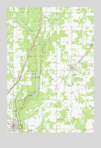
Sandstone North, MN USGS Topographic Map
Click on map above to begin viewing in our Map Viewer.

This topographic map contains these locations and features:
Feature Name Type Latitude Longitude GNIS ID View Map
AskovLocaleN46.1883°W92.7814°2070025View Map
AskovPopulated PlaceN46.1866°W92.7824°639478View Map
Askov City HallBuildingN46.1911°W92.7806°2070028View Map
Askov Post OfficePost OfficeN46.1900°W92.7806°2070026View Map
Askov Volunteer Fire DepartmentBuildingN46.1912°W92.7806°2070029View Map
Assembly of God ChurchChurchN46.1344°W92.8633°2069882View Map
BanningPopulated PlaceN46.1605°W92.8519°654585View Map
Banning CampgroundLocaleN46.1569°W92.8542°2070012View Map
Banning State ParkParkN46.1708°W92.8441°1815047View Map
Bethlehem Lutheran ChurchChurchN46.1867°W92.7822°2070024View Map
Bethlehem Lutheran Church CemeteryCemeteryN46.1861°W92.7917°2069867View Map
Big Sink HoleLakeN46.1719°W92.7882°1815044View Map
Cane CreekStreamN46.2247°W92.8355°640865View Map
Cartway TrailTrailN46.1583°W92.8528°2070052View Map
Church of VictoryChurchN46.1867°W92.7822°2070022View Map
City of AskovCivilN46.1886°W92.7824°2394004View Map
City of SandstoneCivilN46.1292°W92.8645°2396533View Map
Community Worship CenterChurchN46.1261°W92.8700°2069878View Map
Cut-off TrailTrailN46.1583°W92.8528°2070051View Map
Deadman TrailTrailN46.1583°W92.8528°2070049View Map
Dell Grove Emmanuel Lutheran ChurchChurchN46.1275°W92.8636°2069887View Map
East Central Elementary SchoolSchoolN46.1328°W92.8636°2069895View Map
East Central Middle SchoolSchoolN46.1889°W92.7831°2070027View Map
Essentia Health Pine Medical CenterHospitalN46.1269°W92.8652°2069892View Map
Evangelical Free ChurchChurchN46.1336°W92.8653°2069883View Map
Harvest Christian SchoolSchoolN46.1261°W92.8706°2069877View Map
Hells Gate RapidsRapidsN46.1569°W92.8480°1815045View Map
Hells Gate TrailTrailN46.1583°W92.8528°2070050View Map
High Bluff TrailTrailN46.1583°W92.8528°2070047View Map
Interchange 195CrossingN46.1797°W92.8556°2070056View Map
Johnson ParkParkN46.1311°W92.8672°2069900View Map
Johnson's Sunset Mobile Home ParkPopulated PlaceN46.1425°W92.8658°2069855View Map
Kettle River North Bound Rest AreaLocaleN46.2114°W92.8372°2070054View Map
Kettle River Rapids Geological MarkerParkN46.1711°W92.8481°2069906View Map
Log Drive CreekStreamN46.2063°W92.8305°646997View Map
Lower Hell's Gate TrailTrailN46.1583°W92.8528°2069901View Map
Lumbering in Minnesota Historical MarkerParkN46.2114°W92.8372°2070055View Map
Military Road Historical MarkerParkN46.1711°W92.8481°2069907View Map
Pine County Historical MuseumBuildingN46.1867°W92.7822°2070021View Map
Quarry Loop TrailTrailN46.1583°W92.8528°2070048View Map
Quarry RapidsRapidsN46.1342°W92.8564°2069905View Map
Railroad ParkParkN46.1311°W92.8681°2069899View Map
Robinson ParkParkN46.1306°W92.8583°2069898View Map
Saint Luke's Catholic ChurchChurchN46.1294°W92.8667°2069884View Map
SandstoneLocaleN46.1328°W92.8681°2069889View Map
SandstonePopulated PlaceN46.1311°W92.8674°651181View Map
Sandstone Area Country ClubLocaleN46.1347°W92.8722°2069894View Map
Sandstone Area Nursing HomeHospitalN46.1272°W92.8653°2069893View Map
Sandstone History and Art CenterBuildingN46.1322°W92.8667°2069890View Map
Sandstone Post OfficePost OfficeN46.1334°W92.8656°2069891View Map
Sandstone Public LibraryBuildingN46.1325°W92.8661°2069856View Map
Sandstone Volunteer Fire DepartmentBuildingN46.1286°W92.8698°2666632View Map
Skunk Cabbage TrailTrailN46.1583°W92.8528°2070045View Map
Spur TrailTrailN46.1583°W92.8528°2069902View Map
The Church of Jesus Christ of Latter Day SaintsChurchN46.1867°W92.7822°2070023View Map
Township of FinlaysonCivilN46.2014°W92.8632°664169View Map
Township TrailTrailN46.1583°W92.8528°2070043View Map
Trillium TrailTrailN46.1583°W92.8528°2070044View Map
Trinity Lutheran ChurchChurchN46.1306°W92.8656°2069886View Map
United Church of ChristChurchN46.1303°W92.8656°2069885View Map
Watertower ParkParkN46.1325°W92.8583°2069897View Map
Wolf CreekStreamN46.1449°W92.8610°654302View Map
Wolf Creek FallsFallsN46.1466°W92.8608°1815046View Map
Wolf Creek TrailTrailN46.1583°W92.8528°2070046View Map
Zion Lutheran ChurchChurchN46.1311°W92.8672°2069888View Map

Note: Coordinates in the location and feature list above are referenced to NAD83 datum.


Copyright (C) 2008-2024 Ryan Niemi / Sunset Dynamics ... All Rights Reserved