TopoQuest Logo
Do you find TopoQuest useful?
Help keep TopoQuest running and adding new maps/features by donating!
Bitcoin:  19c7KJd3qBynnjoSw5npx9KScwjBe4ifkT
Litecoin:  LXs6TkuXGGXo1vDsWCkWVdjQX94eUKd6ui
Home View Maps Find Maps Find Places Resources & Links


Flat Rock, Illinois Topographic Map

USGS Map Title: Flat Rock, IL
USGS Map MRC: 38087H6
DRG (GeoTIFF) Download: o38087h6.tif


Neighboring USGS Topographic Map Quads:


  Porterville, IL  
39087A7
 

  Hutsonville, IL  
39087A6
 

  Merom, IN  
39087A5
 

  Stoy, IL  
38087H7
 

  Flat Rock, IL  
38087H6
 

  Heathsville, IL  
38087H5
 

  Chauncey, IL  
38087G7
 

  Birds, IL  
38087G6
 

  Russellville, IL  
38087G5


Map MRC Location:

N39°
W88°
N39°
W87°
H8 H7 H6 H5 H4 H3 H2 H1
G8 G7 G6 G5 G4 G3 G2 G1
F8 F7 F6 F5 F4 F3 F2 F1
E8 E7 E6 E5 E4 E3 E2 E1
D8 D7 D6 D5 D4 D3 D2 D1
C8 C7 C6 C5 C4 C3 C2 C1
B8 B7 B6 B5 B4 B3 B2 B1
A8 A7 A6 A5 A4 A3 A2 A1
N38°
W88°
N38°
W87°

Flat Rock, IL USGS 1:24K Topographic Map Preview:
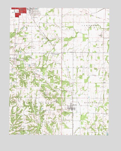
Flat Rock, IL USGS Topographic Map
Click on map above to begin viewing in our Map Viewer.

This topographic map contains these locations and features:
Feature Name Type Latitude Longitude GNIS ID View Map
Antoka FarmsLocaleN38.9533°W87.6389°2725108View Map
Beckwith CemeteryCemeteryN38.9448°W87.6861°404082View Map
Brown School (historical)SchoolN38.9412°W87.7039°1736247View Map
Buncombe School (historical)SchoolN38.9892°W87.6706°1736248View Map
Campbell LakeReservoirN38.8764°W87.6266°1692305View Map
Campbell Lake DamDamN38.8750°W87.6267°1692304View Map
Cecedar CemeteryCemeteryN38.9028°W87.7145°405726View Map
City ParkParkN38.9967°W87.7414°1736254View Map
Clark School (historical)SchoolN38.8945°W87.7459°1736255View Map
Dickerson CemeteryCemeteryN38.8964°W87.6261°407196View Map
DuncanvillePopulated PlaceN38.9548°W87.6956°407490View Map
Duncanville CemeteryCemeteryN38.9559°W87.6961°1934872View Map
Flat RockPopulated PlaceN38.9017°W87.6717°408445View Map
Flat Rock Area Fire Protection DistrictBuildingN38.9001°W87.6711°2681985View Map
Flat Rock Post OfficePost OfficeN38.9003°W87.6721°2725119View Map
Ford CemeteryCemeteryN38.8842°W87.6436°408495View Map
Good Hope CemeteryCemeteryN38.8986°W87.7036°409150View Map
Guyer FarmsLocaleN38.9456°W87.6314°2725101View Map
Higgins CemeteryCemeteryN38.9709°W87.6300°410204View Map
Hope School (historical)SchoolN38.9267°W87.6697°1736262View Map
Jones CemeteryCemeteryN38.8892°W87.6789°411210View Map
La Motte School (historical)SchoolN38.9670°W87.7081°1736264View Map
McCarthy School (historical)SchoolN38.9834°W87.7392°1736270View Map
Meskimmon School (historical)SchoolN38.9567°W87.6686°1736273View Map
Miller FarmsLocaleN38.9328°W87.6339°2725104View Map
Mills School (historical)SchoolN38.9667°W87.6328°1736274View Map
Minnick CemeteryCemeteryN38.9700°W87.7036°413655View Map
Montgomery School (historical)SchoolN38.8925°W87.6445°1736276View Map
MoreaPopulated PlaceN38.9267°W87.6322°422998View Map
Neathery CemeteryCemeteryN38.9728°W87.6353°414328View Map
New HebronPopulated PlaceN38.9500°W87.7445°414406View Map
New Hebron Baptist ChurchChurchN38.9495°W87.7447°1807722View Map
Rich CemeteryCemeteryN38.9209°W87.6909°416590View Map
Rich Pork FarmLocaleN38.9247°W87.7214°2725097View Map
Seaney CemeteryCemeteryN38.9342°W87.6467°418163View Map
Shady Lane Fish FarmLocaleN38.9050°W87.7453°2725118View Map
Swaringen ChurchChurchN38.9567°W87.6703°419470View Map
Swearingen CemeteryCemeteryN38.9548°W87.6706°1940776View Map
Taylor School (historical)SchoolN38.8873°W87.7078°1736291View Map
Tohill CemeteryCemeteryN38.9184°W87.7125°419757View Map
Township of Honey CreekCivilN38.9026°W87.7326°429144View Map
Triple F FarmsLocaleN38.9406°W87.6822°2725093View Map
Union ChurchChurchN38.9112°W87.7131°420053View Map
Union School (historical)SchoolN38.9153°W87.7131°1736292View Map
Village of Flat RockCivilN38.9037°W87.6734°2398883View Map

Note: Coordinates in the location and feature list above are referenced to NAD83 datum.


Copyright (C) 2008-2025 Ryan Niemi / Sunset Dynamics ... All Rights Reserved