TopoQuest Logo
Do you find TopoQuest useful?
Help keep TopoQuest running and adding new maps/features by donating!
Bitcoin:  19c7KJd3qBynnjoSw5npx9KScwjBe4ifkT
Litecoin:  LXs6TkuXGGXo1vDsWCkWVdjQX94eUKd6ui
Home View Maps Find Maps Find Places Resources & Links


Russellville, Illinois Topographic Map

USGS Map Title: Russellville, IL
USGS Map MRC: 38087G5
DRG (GeoTIFF) Download: o38087g5.tif


Neighboring USGS Topographic Map Quads:


  Flat Rock, IL  
38087H6
 

  Heathsville, IL  
38087H5
 

  Carlisle, IN  
38087H4
 

  Birds, IL  
38087G6
 

  Russellville, IL  
38087G5
 

  Oaktown, IN  
38087G4
 

  Lawrenceville, IL  
38087F6
 

  Vincennes, IN  
38087F5
 

  Fritchton, IN  
38087F4


Map MRC Location:

N39°
W88°
N39°
W87°
H8 H7 H6 H5 H4 H3 H2 H1
G8 G7 G6 G5 G4 G3 G2 G1
F8 F7 F6 F5 F4 F3 F2 F1
E8 E7 E6 E5 E4 E3 E2 E1
D8 D7 D6 D5 D4 D3 D2 D1
C8 C7 C6 C5 C4 C3 C2 C1
B8 B7 B6 B5 B4 B3 B2 B1
A8 A7 A6 A5 A4 A3 A2 A1
N38°
W88°
N38°
W87°

Russellville, IL USGS 1:24K Topographic Map Preview:
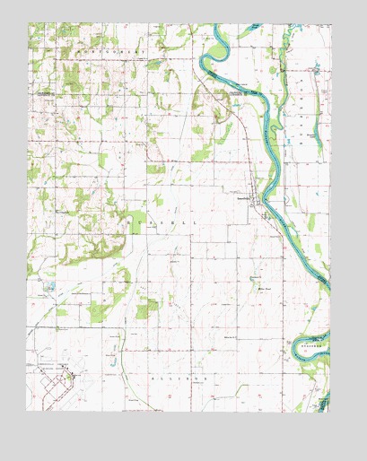
Russellville, IL USGS Topographic Map
Click on map above to begin viewing in our Map Viewer.

This topographic map contains these locations and features:
Feature Name Type Latitude Longitude GNIS ID View Map
Allison CemeteryCemeteryN38.8359°W87.5761°403441View Map
Allison Post Office (historical)Post OfficeN38.7620°W87.5967°1816164View Map
Brick School Number 3 (historical)SchoolN38.7700°W87.5625°1764748View Map
Broadie LakeLakeN38.8390°W87.5058°431547View Map
Canaan Primitive Baptist ChurchChurchN38.8637°W87.5761°405540View Map
Canaan School (historical)SchoolN38.8670°W87.5753°1736249View Map
Centerville CemeteryCemeteryN38.7620°W87.5864°405842View Map
Centerville School (historical)SchoolN38.7625°W87.6031°1764753View Map
Church of the BrethrenChurchN38.7878°W87.5989°406109View Map
Cughan CemeteryCemeteryN38.7578°W87.5058°406879View Map
DavyPopulated PlaceN38.8667°W87.5972°446749View Map
Ditch Number 2CanalN38.7620°W87.5550°1764759View Map
East Pinkstaff ChurchChurchN38.8142°W87.6131°407685View Map
East Pinkstaff School (historical)SchoolN38.8073°W87.6136°1764760View Map
Ed-Air AirportAirportN38.8578°W87.5005°449294View Map
Ferrell CemeteryCemeteryN38.8525°W87.5772°1934876View Map
Hale CemeteryCemeteryN38.8550°W87.6059°409623View Map
Hazel Dell School (historical)SchoolN38.8448°W87.5478°1764772View Map
Higgins CemeteryCemeteryN38.8659°W87.6159°1940753View Map
Higgins School (historical)SchoolN38.8664°W87.6131°1736260View Map
Howard CemeteryCemeteryN38.7764°W87.6120°410606View Map
Lagow CemeteryCemeteryN38.7847°W87.5410°411690View Map
Lawrenceville-Vincennes International AirportAirportN38.7643°W87.6055°427438View Map
M and J FarmsLocaleN38.8642°W87.5822°2725116View Map
Miller PondLakeN38.7926°W87.5324°413590View Map
Miller School (historical)SchoolN38.7962°W87.5389°1764786View Map
Mohn School (historical)SchoolN38.8364°W87.6136°1764787View Map
Niblack LeveeLeveeN38.8312°W87.5189°440158View Map
North Center School (historical)SchoolN38.7884°W87.5984°1764788View Map
Norton CemeteryCemeteryN38.8673°W87.5706°414713View Map
Old Busseron CreekStreamN38.8378°W87.5259°440545View Map
Otterburn CemeteryCemeteryN38.7598°W87.5568°415232View Map
Price CemeteryCemeteryN38.8209°W87.5381°416209View Map
Rising Sun ChurchChurchN38.7745°W87.5389°416693View Map
Rising Sun School (historical)SchoolN38.7820°W87.5192°1764800View Map
RussellvillePopulated PlaceN38.8189°W87.5317°417068View Map
Saint Paul CemeteryCemeteryN38.8498°W87.6139°417695View Map
Swan IslandIslandN38.8553°W87.5400°444458View Map
Taylor DitchCanalN38.8298°W87.5639°419562View Map
Tevealt CemeteryCemeteryN38.8253°W87.5314°419610View Map
Tobey CemeteryCemeteryN38.8739°W87.5695°419751View Map
Township of RussellCivilN38.8081°W87.5700°429686View Map
Union School (historical)SchoolN38.8364°W87.5764°1764806View Map
Village of RussellvilleCivilN38.8198°W87.5300°2399148View Map
Vincennes Executive Inn Airport (historical)AirportN38.8434°W87.5011°449371View Map

Note: Coordinates in the location and feature list above are referenced to NAD83 datum.


Copyright (C) 2008-2025 Ryan Niemi / Sunset Dynamics ... All Rights Reserved