TopoQuest Logo
Do you find TopoQuest useful?
Help keep TopoQuest running and adding new maps/features by donating!
Bitcoin:  19c7KJd3qBynnjoSw5npx9KScwjBe4ifkT
Litecoin:  LXs6TkuXGGXo1vDsWCkWVdjQX94eUKd6ui
Home View Maps Find Maps Find Places Resources & Links


Heathsville, Illinois Topographic Map

USGS Map Title: Heathsville, IL
USGS Map MRC: 38087H5
DRG (GeoTIFF) Download: o38087h5.tif


Neighboring USGS Topographic Map Quads:


  Hutsonville, IL  
39087A6
 

  Merom, IN  
39087A5
 

  Sullivan, IN  
39087A4
 

  Flat Rock, IL  
38087H6
 

  Heathsville, IL  
38087H5
 

  Carlisle, IN  
38087H4
 

  Birds, IL  
38087G6
 

  Russellville, IL  
38087G5
 

  Oaktown, IN  
38087G4


Map MRC Location:

N39°
W88°
N39°
W87°
H8 H7 H6 H5 H4 H3 H2 H1
G8 G7 G6 G5 G4 G3 G2 G1
F8 F7 F6 F5 F4 F3 F2 F1
E8 E7 E6 E5 E4 E3 E2 E1
D8 D7 D6 D5 D4 D3 D2 D1
C8 C7 C6 C5 C4 C3 C2 C1
B8 B7 B6 B5 B4 B3 B2 B1
A8 A7 A6 A5 A4 A3 A2 A1
N38°
W88°
N38°
W87°

Heathsville, IL USGS 1:24K Topographic Map Preview:
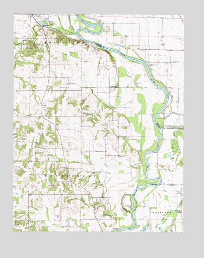
Heathsville, IL USGS Topographic Map
Click on map above to begin viewing in our Map Viewer.

This topographic map contains these locations and features:
Feature Name Type Latitude Longitude GNIS ID View Map
Adams School (historical)SchoolN38.9323°W87.5561°1736242View Map
Allen CemeteryCemeteryN38.8956°W87.6114°403421View Map
Bailey FarmLocaleN38.9406°W87.6144°2725103View Map
Baker CemeteryCemeteryN38.9017°W87.5606°403820View Map
Bartmess CemeteryCemeteryN38.9295°W87.5445°403943View Map
Bennett CemeteryCemeteryN38.9485°W87.6035°1934845View Map
Brightlight Ferry (historical)LocaleN38.9864°W87.5764°1736246View Map
Bristol HillSummitN38.9820°W87.5750°404876View Map
Buzzard PondLakeN38.9820°W87.5470°431920View Map
Cannon School (historical)SchoolN38.9039°W87.5586°1736250View Map
Centennial School (historical)SchoolN38.9639°W87.5975°1736252View Map
East Union CemeteryCemeteryN38.9575°W87.5847°407705View Map
Fuller CemeteryCemeteryN38.9120°W87.5856°408793View Map
Ganies CemeteryCemeteryN38.9017°W87.5947°408868View Map
Gill Township LeveeLeveeN38.9825°W87.5450°435074View Map
Gordon Goat FarmLocaleN38.9547°W87.5864°2725107View Map
Grace ChurchChurchN38.9473°W87.6039°409226View Map
Grays PondLakeN38.8756°W87.5293°435373View Map
Green CemeteryCemeteryN38.9856°W87.6111°409376View Map
Green CemeteryCemeteryN38.8892°W87.6109°1934882View Map
Green Hill CemeteryCemeteryN38.9186°W87.5475°1934884View Map
Green Hill ChurchChurchN38.9187°W87.5478°409384View Map
HeathsvillePopulated PlaceN38.8967°W87.5678°410007View Map
Hite Ferry (historical)CrossingN38.9578°W87.5172°1807717View Map
Horseshoe CutoffBendN38.8760°W87.5469°410566View Map
Indian MoundSummitN38.9803°W87.6153°410870View Map
Johnson CemeteryCemeteryN38.8839°W87.5909°411154View Map
Johnsons CutoffChannelN38.8898°W87.5375°437043View Map
Lackey CemeteryCemeteryN38.9423°W87.5711°411675View Map
Lamotte CreekStreamN38.9881°W87.5784°411784View Map
Leaverton ParkParkN38.9948°W87.5972°411897View Map
Long PondLakeN38.9611°W87.5360°412597View Map
Longtown Ferry (historical)LocaleN38.9014°W87.5334°1736267View Map
Maddox CemeteryCemeteryN38.9236°W87.6011°1934901View Map
Mann AirportAirportN38.9853°W87.5169°449262View Map
McKiven School (historical)SchoolN38.8967°W87.6045°1736271View Map
Milam CemeteryCemeteryN38.9731°W87.5081°439131View Map
Minnow SloughStreamN38.9889°W87.5800°413657View Map
Morea CemeteryCemeteryN38.9261°W87.6225°413806View Map
No Business CreekStreamN38.9128°W87.5270°414539View Map
Pleasant View CemeteryCemeteryN38.9209°W87.5589°1940761View Map
Pleasant View ChurchChurchN38.9214°W87.5595°415920View Map
RichwoodsPopulated PlaceN38.9581°W87.5542°423116View Map
Ryan FarmsLocaleN38.9525°W87.6236°2725109View Map
Shaw CemeteryCemeteryN38.9131°W87.5381°1940770View Map
Shawn HillSummitN38.9770°W87.5556°418315View Map
Shaws LandingLocaleN38.9131°W87.5300°1736287View Map
Stoner FarmsLocaleN38.9736°W87.6006°2725110View Map
Sugar CreekStreamN38.8773°W87.5464°419263View Map
Sugar CreekStreamN38.9898°W87.5828°419279View Map
Sweet CreekStreamN38.8906°W87.5584°419478View Map
Township of MontgomeryCivilN38.9069°W87.5995°429388View Map
Washington Elementary and Junior High SchoolSchoolN38.9659°W87.5328°447573View Map
Wesley Chapel CemeteryCemeteryN38.9484°W87.6036°1940780View Map
Wheeler School (historical)SchoolN38.9278°W87.5903°1736297View Map

Note: Coordinates in the location and feature list above are referenced to NAD83 datum.


Copyright (C) 2008-2024 Ryan Niemi / Sunset Dynamics ... All Rights Reserved