TopoQuest Logo
Do you find TopoQuest useful?
Help keep TopoQuest running and adding new maps/features by donating!
Bitcoin:  19c7KJd3qBynnjoSw5npx9KScwjBe4ifkT
Litecoin:  LXs6TkuXGGXo1vDsWCkWVdjQX94eUKd6ui
Home View Maps Find Maps Find Places Resources & Links


Flathead Pass, Montana Topographic Map

USGS Map Title: Flathead Pass, MT
USGS Map MRC: 45111H1
DRG (GeoTIFF) Download: o45111h1.tif


Neighboring USGS Topographic Map Quads:


  Maudlow, MT  
46111A2
 

  Blacktail Mountain, MT  
46111A1
 

  Hatfield Mountain, MT  
46110A8
 

  Horseshoe Creek, MT  
45111H2
 

  Flathead Pass, MT  
45111H1
 

  Sacagawea Peak, MT  
45110H8
 

  Belgrade, MT  
45111G2
 

  Miser Creek, MT  
45111G1
 

  Saddle Peak, MT  
45110G8


Map MRC Location:

N46°
W112°
N46°
W111°
H8 H7 H6 H5 H4 H3 H2 H1
G8 G7 G6 G5 G4 G3 G2 G1
F8 F7 F6 F5 F4 F3 F2 F1
E8 E7 E6 E5 E4 E3 E2 E1
D8 D7 D6 D5 D4 D3 D2 D1
C8 C7 C6 C5 C4 C3 C2 C1
B8 B7 B6 B5 B4 B3 B2 B1
A8 A7 A6 A5 A4 A3 A2 A1
N45°
W112°
N45°
W111°

Flathead Pass, MT USGS 1:24K Topographic Map Preview:
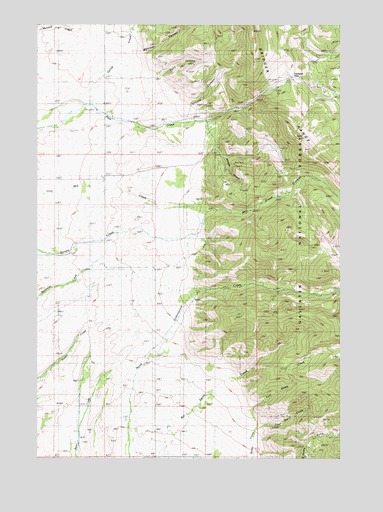
Flathead Pass, MT USGS Topographic Map
Click on map above to begin viewing in our Map Viewer.

This topographic map contains these locations and features:
Feature Name Type Latitude Longitude GNIS ID View Map
02N05E04DADD01 WellWellN45.9522°W111.0986°813535View Map
02N05E10BDBD01 WellWellN45.9435°W111.0905°813495View Map
02N05E15AC__01 SpringSpringN45.9283°W111.0847°813408View Map
02N05E21BBCC01 WellWellN45.9135°W111.1211°813334View Map
02N05E22DDAD01 WellWellN45.9066°W111.0774°813265View Map
02N05E23CD__01 SpringSpringN45.9063°W111.0691°813258View Map
02N05E27DD__01 SpringSpringN45.8919°W111.0797°813136View Map
02N05E28CD__01 WellWellN45.8919°W111.1108°813137View Map
02N05E33BD__01 WellWellN45.8847°W111.1108°813075View Map
02N05E33CA__01 WellWellN45.8810°W111.1108°813035View Map
02N05E34AD__01 SpringSpringN45.8847°W111.0797°813074View Map
02N05E34DA__01 WellWellN45.8810°W111.0797°813034View Map
02N05E34DDBB01 WellWellN45.8785°W111.0808°813016View Map
02N05E34DDC_01 WellWellN45.8766°W111.0808°812999View Map
02N05E34DDD_01 WellWellN45.8766°W111.0783°812998View Map
02N05E35BA__01 WellWellN45.8883°W111.0691°813107View Map
03N05E28DD__01 WellWellN45.9794°W111.1011°813670View Map
Belgrade DivisionCivilN45.9694°W111.0409°1940566View Map
Central Valley Fire District Station 4BuildingN45.8758°W111.0800°2546560View Map
Duncan Post Office (historical)Post OfficeN45.9463°W111.0966°1743733View Map
Evan Reese CreekStreamN45.8830°W111.0361°783252View Map
Felix CanyonValleyN45.9852°W111.0788°771323View Map
Flathead PassGapN45.9819°W111.0144°771455View Map
Gallop (historical)Populated PlaceN45.9763°W111.0994°1743873View Map
Gallop CreekStreamN45.9769°W111.1072°783815View Map
Gallop Post Office (historical)Post OfficeN45.9763°W111.0994°1743793View Map
Grouse CanyonValleyN45.9747°W111.0644°772013View Map
Johnson CanyonValleyN45.9699°W111.0561°772859View Map
Mill Creek CanyonValleyN45.9458°W111.0586°787372View Map
Morrison CanyonValleyN45.9922°W111.0830°787708View Map
Mountain View School (historical)SchoolN45.9297°W111.0980°774433View Map
Pass Creek MineMineN45.9527°W111.0249°802992View Map
Pass Creek SchoolSchoolN45.9772°W111.0983°775104View Map
Reese Creek School (historical)SchoolN45.8760°W111.0808°775689View Map
Sept Morn MineMineN45.9533°W111.0249°802991View Map
Springhill Census Designated PlaceCensusN45.8787°W111.0774°2583851View Map
Stock Drive TrailTrailN45.9883°W111.0077°777222View Map
Tom Reese CreekStreamN45.8835°W111.0361°792255View Map

Note: Coordinates in the location and feature list above are referenced to NAD83 datum.


Copyright (C) 2008-2024 Ryan Niemi / Sunset Dynamics ... All Rights Reserved