TopoQuest Logo
Do you find TopoQuest useful?
Help keep TopoQuest running and adding new maps/features by donating!
Bitcoin:  19c7KJd3qBynnjoSw5npx9KScwjBe4ifkT
Litecoin:  LXs6TkuXGGXo1vDsWCkWVdjQX94eUKd6ui
Home View Maps Find Maps Find Places Resources & Links


Flomaton, Alabama Topographic Map

USGS Map Title: Flomaton, AL
USGS Map MRC: 31087A3
DRG (GeoTIFF) Download: o31087a3.tif


Neighboring USGS Topographic Map Quads:


  Huxford, AL  
31087B4
 

  Barnett Crossroads, AL  
31087B3
 

  Wallace, AL  
31087B2
 

  Atmore, AL  
31087A4
 

  Flomaton, AL  
31087A3
 

  Pollard, AL  
31087A2
 

  Bratt, FL  
30087H4
 

  Century, FL  
30087H3
 

  Jay, FL  
30087H2


Map MRC Location:

N32°
W88°
N32°
W87°
H8 H7 H6 H5 H4 H3 H2 H1
G8 G7 G6 G5 G4 G3 G2 G1
F8 F7 F6 F5 F4 F3 F2 F1
E8 E7 E6 E5 E4 E3 E2 E1
D8 D7 D6 D5 D4 D3 D2 D1
C8 C7 C6 C5 C4 C3 C2 C1
B8 B7 B6 B5 B4 B3 B2 B1
A8 A7 A6 A5 A4 A3 A2 A1
N31°
W88°
N31°
W87°

Flomaton, AL USGS 1:24K Topographic Map Preview:
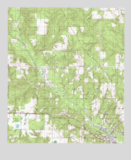
Flomaton, AL USGS Topographic Map
Click on map above to begin viewing in our Map Viewer.

This topographic map contains these locations and features:
Feature Name Type Latitude Longitude GNIS ID View Map
Abernathy Memorial Hospital (historical)HospitalN31.0021°W87.2666°137019View Map
Ballentine School (historical)SchoolN31.0724°W87.3694°133748View Map
Bethel Baptist ChurchChurchN31.0021°W87.2630°137022View Map
Big BranchStreamN31.0377°W87.2916°114225View Map
Bills BranchStreamN31.0402°W87.3091°114344View Map
Bowman CemeteryCemeteryN31.0302°W87.3680°114779View Map
Church of ChristChurchN31.0030°W87.2642°2580362View Map
Cowpen CreekStreamN31.0591°W87.3372°116768View Map
Dry BranchStreamN31.0380°W87.2922°117494View Map
Emmons CemeteryCemeteryN31.0705°W87.2769°117984View Map
First Baptist ChurchChurchN31.0035°W87.2630°137025View Map
First United Methodist ChurchChurchN31.0024°W87.2603°137027View Map
Flomation Post OfficePost OfficeN31.0014°W87.2603°168552View Map
FlomatonPopulated PlaceN31.0002°W87.2608°157953View Map
Flomaton AirportAirportN31.0305°W87.2518°129384View Map
Flomaton DivisionCivilN31.1087°W87.2802°165766View Map
Flomaton Elementary SchoolSchoolN31.0043°W87.2687°133795View Map
Flomaton Fire Chief OfficeBuildingN31.0196°W87.2521°2331045View Map
Flomaton Gas FieldOilfieldN31.0688°W87.2764°151180View Map
Flomaton High SchoolSchoolN31.0060°W87.2699°133796View Map
Flomaton Pentecostal Holiness ChurchChurchN31.0067°W87.2627°137029View Map
Flomaton Police DepartmentBuildingN31.0009°W87.2606°2751867View Map
Flomaton Public LibraryBuildingN31.0042°W87.2598°2579913View Map
Flomaton Sewage LagoonLocaleN31.0082°W87.2520°2579649View Map
Flomaton Volunteer Fire DepartmentBuildingN31.0197°W87.2548°2331029View Map
Full Gospel Fellowship ChurchChurchN31.0052°W87.3047°133802View Map
Greater Revelation Missionary Baptist ChurchChurchN31.0011°W87.2621°2580364View Map
Greater Union Baptist ChurchChurchN31.0092°W87.2511°117030View Map
Hall Creek Oil FieldOilfieldN31.0991°W87.2911°151181View Map
Halls Creek Baptist ChurchChurchN31.1216°W87.2772°119583View Map
Halls Creek Church CemeteryCemeteryN31.1221°W87.2766°163140View Map
Hammac CemeteryCemeteryN31.1138°W87.2911°119649View Map
Johnson BranchStreamN31.0882°W87.3375°120924View Map
Lake WeaverLakeN31.0059°W87.2902°128674View Map
Lambeth ChurchChurchN31.0707°W87.2980°151983View Map
Lambeth Community Volunteer Fire DepartmentBuildingN31.0575°W87.3039°2691134View Map
Lambeth-Boutwell CemeteryCemeteryN31.0705°W87.2969°133818View Map
Little Escambia Baptist ChurchChurchN31.0266°W87.2541°152093View Map
Little Escambia CemeteryCemeteryN31.0266°W87.2550°133819View Map
Mize CemeteryCemeteryN31.0366°W87.2591°152354View Map
Moyeville Baptist ChurchChurchN31.1074°W87.3439°152559View Map
Moyeville Church CemeteryCemeteryN31.1074°W87.3436°133840View Map
Murray BranchStreamN31.0743°W87.3475°123610View Map
Osaka ChurchChurchN31.0713°W87.2711°133849View Map
Pineview Baptist ChurchChurchN31.1238°W87.2572°152936View Map
Pineview Church CemeteryCemeteryN31.1243°W87.2575°133856View Map
Pineview SchoolSchoolN31.1246°W87.2583°133857View Map
Pond CreekStreamN31.0443°W87.3139°125115View Map
Red Oak ChurchChurchN31.1163°W87.2766°133867View Map
Rock BranchStreamN31.0330°W87.2950°125742View Map
Rock CemeteryCemeteryN31.0182°W87.2661°133869View Map
Rock ChurchChurchN31.0180°W87.2658°125745View Map
Sardis Baptist ChurchChurchN31.0310°W87.3450°153330View Map
Sardis Church CemeteryCemeteryN31.0310°W87.3452°133874View Map
Sizemore CreekStreamN31.0932°W87.3614°153461View Map
Sizemore Creek Gas FieldOilfieldN31.1002°W87.3672°151187View Map
Sizemore Creek Oil FieldOilfieldN31.1002°W87.3611°151188View Map
Spring Hill ChurchChurchN31.0052°W87.3069°127243View Map
Town of FlomatonCivilN31.0127°W87.2542°2406500View Map
Travelers Rest CemeteryCemeteryN31.0502°W87.3005°128050View Map
WawbeekPopulated PlaceN31.0280°W87.3608°157224View Map
Wawbeek Volunteer Fire DepartmentBuildingN31.0327°W87.3447°2691133View Map
WPIK-AM (Flomaton)TowerN31.0063°W87.2783°160913View Map

Note: Coordinates in the location and feature list above are referenced to NAD83 datum.


Copyright (C) 2008-2025 Ryan Niemi / Sunset Dynamics ... All Rights Reserved