TopoQuest Logo
Do you find TopoQuest useful?
Help keep TopoQuest running and adding new maps/features by donating!
Bitcoin:  19c7KJd3qBynnjoSw5npx9KScwjBe4ifkT
Litecoin:  LXs6TkuXGGXo1vDsWCkWVdjQX94eUKd6ui
Home View Maps Find Maps Find Places Resources & Links


Century, Florida Topographic Map

USGS Map Title: Century, FL
USGS Map MRC: 30087H3
DRG (GeoTIFF) Download: o30087h3.tif


Neighboring USGS Topographic Map Quads:


  Atmore, AL  
31087A4
 

  Flomaton, AL  
31087A3
 

  Pollard, AL  
31087A2
 

  Bratt, FL  
30087H4
 

  Century, FL  
30087H3
 

  Jay, FL  
30087H2
 

  Bay Springs, FL  
30087G4
 

  McDavid, FL  
30087G3
 

  Chumuckla, FL  
30087G2


Map MRC Location:

N31°
W88°
N31°
W87°
H8 H7 H6 H5 H4 H3 H2 H1
G8 G7 G6 G5 G4 G3 G2 G1
F8 F7 F6 F5 F4 F3 F2 F1
E8 E7 E6 E5 E4 E3 E2 E1
D8 D7 D6 D5 D4 D3 D2 D1
C8 C7 C6 C5 C4 C3 C2 C1
B8 B7 B6 B5 B4 B3 B2 B1
A8 A7 A6 A5 A4 A3 A2 A1
N30°
W88°
N30°
W87°

Century, FL USGS 1:24K Topographic Map Preview:
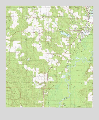
Century, FL USGS Topographic Map
Click on map above to begin viewing in our Map Viewer.

This topographic map contains these locations and features:
Feature Name Type Latitude Longitude GNIS ID View Map
Beth Temple Fellowship ChurchChurchN30.9677°W87.3436°278518View Map
Beulah ChurchChurchN30.9841°W87.3311°278593View Map
Bluff SpringsPopulated PlaceN30.9363°W87.2947°307656View Map
Bluff Springs ChurchChurchN30.9513°W87.2850°279088View Map
Bluff Springs LakeLakeN30.9335°W87.3431°279089View Map
Byrnesville ChurchChurchN30.9682°W87.3461°279779View Map
ByrnevillePopulated PlaceN30.9663°W87.3269°295167View Map
Byrneville Elementary SchoolSchoolN30.9641°W87.3261°297899View Map
Campbell CreekStreamN30.9027°W87.2850°279947View Map
Carlney CemeteryCemeteryN30.9088°W87.2580°280036View Map
Carlney LakeLakeN30.9338°W87.2515°280037View Map
Carver High SchoolSchoolN30.9671°W87.2655°280097View Map
CenturyPopulated PlaceN30.9732°W87.2639°280274View Map
Century Correctional InstitutionBuildingN30.9586°W87.2928°2753060View Map
Century DivisionCivilN30.8823°W87.3568°1935720View Map
Century Elementary SchoolSchoolN30.9738°W87.2569°297898View Map
Century Memorial HospitalHospitalN30.9705°W87.2575°298574View Map
Century Post OfficePost OfficeN30.9825°W87.2569°2783411View Map
Century Senior High SchoolSchoolN30.9730°W87.2533°297897View Map
Christian SchoolSchoolN30.9685°W87.2569°280427View Map
Escambia County Fire and Rescue Station 5 CenturyBuildingN30.9560°W87.2794°2644074View Map
Escambia County Sheriff's Office - Precinct 6 CenturyBuildingN30.9705°W87.2660°2754471View Map
Flomaton Fire DepartmentBuildingN30.9999°W87.2625°2331003View Map
GandyvillePopulated PlaceN30.9971°W87.2883°295309View Map
Grace ChurchChurchN30.8888°W87.3205°283255View Map
Lake StoneReservoirN30.9653°W87.2901°291726View Map
Malone Hammock BranchStreamN30.8802°W87.2814°286336View Map
McCostill Mill CreekStreamN30.8799°W87.2814°286588View Map
Mill CreekStreamN30.9588°W87.2636°122752View Map
Mitchell CreekStreamN30.8752°W87.3122°287006View Map
Pleasant Hill ChurchChurchN30.9302°W87.3011°289068View Map
Poplar Dell ChurchChurchN30.9860°W87.3211°289202View Map
Pritchell Mill BranchStreamN30.9299°W87.2769°289332View Map
Reedy CreekStreamN30.9691°W87.3691°112830View Map
Round LakeReservoirN30.9260°W87.2783°290005View Map
Saint Lukes ChurchChurchN30.9843°W87.2803°290277View Map
Salters LakeLakeN30.9474°W87.2637°290441View Map
Sandy HollowValleyN30.8854°W87.2683°290618View Map
South FlomatonPopulated PlaceN30.9918°W87.2575°291370View Map
Sugar Hill ChurchChurchN30.9585°W87.3441°291774View Map
Tarzan Railroad StationLocaleN30.9930°W87.2553°300210View Map
Town of CenturyCivilN30.9766°W87.2629°2406251View Map
Wiggins BranchStreamN30.9360°W87.2678°293268View Map
Williams LakeLakeN30.8778°W87.2934°293332View Map

Note: Coordinates in the location and feature list above are referenced to NAD83 datum.


Copyright (C) 2008-2025 Ryan Niemi / Sunset Dynamics ... All Rights Reserved