TopoQuest Logo
Do you find TopoQuest useful?
Help keep TopoQuest running and adding new maps/features by donating!
Bitcoin:  19c7KJd3qBynnjoSw5npx9KScwjBe4ifkT
Litecoin:  LXs6TkuXGGXo1vDsWCkWVdjQX94eUKd6ui
Home View Maps Find Maps Find Places Resources & Links


Cedar Bluff, Mississippi Topographic Map

USGS Map Title: Cedar Bluff, MS
USGS Map MRC: 33088E7
DRG (GeoTIFF) Download: o33088e7.tif


Neighboring USGS Topographic Map Quads:


  Montpelier, MS  
33088F8
 

  Palo Alto, MS  
33088F7
 

  Muldon, MS  
33088F6
 

  Pheba, MS  
33088E8
 

  Cedar Bluff, MS  
33088E7
 

  West Point, MS  
33088E6
 

  Longview, MS  
33088D8
 

  Starkville, MS  
33088D7
 

  Artesia, MS  
33088D6


Map MRC Location:

N34°
W89°
N34°
W88°
H8 H7 H6 H5 H4 H3 H2 H1
G8 G7 G6 G5 G4 G3 G2 G1
F8 F7 F6 F5 F4 F3 F2 F1
E8 E7 E6 E5 E4 E3 E2 E1
D8 D7 D6 D5 D4 D3 D2 D1
C8 C7 C6 C5 C4 C3 C2 C1
B8 B7 B6 B5 B4 B3 B2 B1
A8 A7 A6 A5 A4 A3 A2 A1
N33°
W89°
N33°
W88°

Cedar Bluff, MS USGS 1:24K Topographic Map Preview:
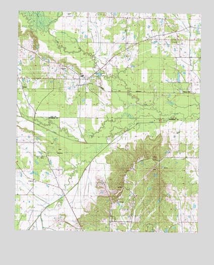
Cedar Bluff, MS USGS Topographic Map
Click on map above to begin viewing in our Map Viewer.

This topographic map contains these locations and features:
Feature Name Type Latitude Longitude GNIS ID View Map
Bock Lake DamDamN33.5118°W88.7601°682156View Map
Bridges Mill (historical)LocaleN33.6023°W88.7520°684739View Map
Camp SeminoleLocaleN33.5446°W88.8459°682895View Map
Cedar BluffPopulated PlaceN33.5868°W88.8323°668181View Map
Cedar Bluff Baptist ChurchChurchN33.5871°W88.8328°684742View Map
Cedar Bluff Methodist ChurchChurchN33.5865°W88.8334°684743View Map
Cedarbluff Post OfficePost OfficeN33.5870°W88.8321°2768837View Map
Cumberland CemeteryCemeteryN33.5932°W88.8439°669013View Map
Deans LakeStreamN33.6143°W88.8573°669180View Map
Hawkins Lake DamDamN33.5901°W88.8217°682223View Map
Henderson Lake DamDamN33.6068°W88.7717°682239View Map
Jennings Lake DamDamN33.6085°W88.7817°682241View Map
Josey CreekStreamN33.5090°W88.8573°672037View Map
Mhoons Farm SchoolSchoolN33.5423°W88.7587°673517View Map
Mhoons ValleyPopulated PlaceN33.5798°W88.7542°673518View Map
Mosley CemeteryCemeteryN33.6234°W88.8417°673868View Map
Mosley LakeStreamN33.6035°W88.8314°673870View Map
Plair United Methodist ChurchChurchN33.5418°W88.8584°675956View Map
PlairsPopulated PlaceN33.5423°W88.8598°682989View Map
Portera Lake DamDamN33.5835°W88.7617°682217View Map
Rock Hill SchoolSchoolN33.5243°W88.8009°676765View Map
Rockhill United Methodist ChurchChurchN33.5254°W88.8014°683001View Map
Rocky HillPopulated PlaceN33.5254°W88.8001°683002View Map
Saint Paul Baptist ChurchChurchN33.5279°W88.8626°677216View Map
Sand Creek Chapel Missionary Baptist ChurchChurchN33.5248°W88.8003°683008View Map
Stacy Lake DamDamN33.5151°W88.7784°682159View Map
Sun CreekStreamN33.5501°W88.8114°678409View Map
Trim Cane CreekStreamN33.5673°W88.7664°678875View Map
Underwood CreekStreamN33.6137°W88.8545°679029View Map
WaddellPopulated PlaceN33.5804°W88.8712°679233View Map

Note: Coordinates in the location and feature list above are referenced to NAD83 datum.


Copyright (C) 2008-2024 Ryan Niemi / Sunset Dynamics ... All Rights Reserved