TopoQuest Logo
Do you find TopoQuest useful?
Help keep TopoQuest running and adding new maps/features by donating!
Bitcoin:  19c7KJd3qBynnjoSw5npx9KScwjBe4ifkT
Litecoin:  LXs6TkuXGGXo1vDsWCkWVdjQX94eUKd6ui
Home View Maps Find Maps Find Places Resources & Links


Tinsman, Arkansas Topographic Map

USGS Map Title: Tinsman, AR
USGS Map MRC: 33092F3
DRG (GeoTIFF) Download: o33092f3.tif


Neighboring USGS Topographic Map Quads:


  Fordyce, AR  
33092G4
 

  Kingsland, AR  
33092G3
 

  New Edinburg, AR  
33092G2
 

  Chambersville, AR  
33092F4
 

  Tinsman, AR  
33092F3
 

  McKinney, AR  
33092F2
 

  Hampton, AR  
33092E4
 

  Banks, AR  
33092E3
 

  Farmville, AR  
33092E2


Map MRC Location:

N34°
W93°
N34°
W92°
H8 H7 H6 H5 H4 H3 H2 H1
G8 G7 G6 G5 G4 G3 G2 G1
F8 F7 F6 F5 F4 F3 F2 F1
E8 E7 E6 E5 E4 E3 E2 E1
D8 D7 D6 D5 D4 D3 D2 D1
C8 C7 C6 C5 C4 C3 C2 C1
B8 B7 B6 B5 B4 B3 B2 B1
A8 A7 A6 A5 A4 A3 A2 A1
N33°
W93°
N33°
W92°

Tinsman, AR USGS 1:24K Topographic Map Preview:
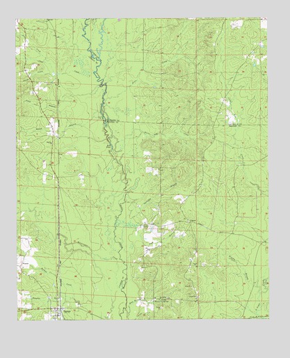
Tinsman, AR USGS Topographic Map
Click on map above to begin viewing in our Map Viewer.

This topographic map contains these locations and features:
Feature Name Type Latitude Longitude GNIS ID View Map
Anna BranchStreamN33.7057°W92.3471°45876View Map
Beech CreekStreamN33.7273°W92.3571°46322View Map
Berks BranchStreamN33.6548°W92.3746°46402View Map
Big SloughGutN33.7084°W92.3313°46599View Map
Blue SpringsSpringN33.6329°W92.3029°46766View Map
Blue Springs (historical)Populated PlaceN33.6337°W92.3076°60493View Map
Blue Springs BranchStreamN33.6296°W92.3215°46767View Map
Blue Springs ChurchChurchN33.6332°W92.3049°46769View Map
Brown BranchStreamN33.6332°W92.3121°60616View Map
Brushy BranchStreamN33.6351°W92.2543°47053View Map
Clear CreekStreamN33.7273°W92.3429°47826View Map
Douglas BranchStreamN33.6340°W92.3476°48582View Map
Dry CreekStreamN33.7321°W92.3610°48645View Map
EllisvillePopulated PlaceN33.7009°W92.3571°69989View Map
Ellisville ChurchChurchN33.6984°W92.3576°48866View Map
Fritz CreekStreamN33.6987°W92.3288°49276View Map
Hunter BranchStreamN33.6254°W92.2540°60486View Map
Lavender BranchStreamN33.6637°W92.3263°51001View Map
Levit (historical)Populated PlaceN33.6840°W92.3549°69991View Map
Lindale (historical)Populated PlaceN33.7426°W92.3549°69992View Map
Parr BranchStreamN33.6559°W92.3243°77958View Map
Rough BranchStreamN33.7112°W92.3332°54231View Map
Scott WaterLakeN33.6976°W92.3280°77309View Map
TinsmanPopulated PlaceN33.6298°W92.3551°55580View Map
Tinsman Fire StationBuildingN33.6296°W92.3573°2117213View Map
Town of TinsmanCivilN33.6292°W92.3533°2406737View Map
Township of MoroCivilN33.6638°W92.2559°63690View Map
WagnonPopulated PlaceN33.6654°W92.2888°78666View Map
Wagnon BranchStreamN33.6437°W92.3210°60617View Map
Wagnon Methodist ChurchChurchN33.6659°W92.2904°60483View Map
WatsonPopulated PlaceN33.6473°W92.3740°58836View Map
White Oak CreekStreamN33.6951°W92.3282°56272View Map
Whitewater CreekStreamN33.6371°W92.3235°56329View Map
Williams CemeteryCemeteryN33.6643°W92.3090°56385View Map
Williford School (historical)SchoolN33.6843°W92.2849°60484View Map

Note: Coordinates in the location and feature list above are referenced to NAD83 datum.


Copyright (C) 2008-2024 Ryan Niemi / Sunset Dynamics ... All Rights Reserved