TopoQuest Logo
Do you find TopoQuest useful?
Help keep TopoQuest running and adding new maps/features by donating!
Bitcoin:  19c7KJd3qBynnjoSw5npx9KScwjBe4ifkT
Litecoin:  LXs6TkuXGGXo1vDsWCkWVdjQX94eUKd6ui
Home View Maps Find Maps Find Places Resources & Links


Fort Defiance, Virginia Topographic Map

USGS Map Title: Fort Defiance, VA
USGS Map MRC: 38078B8
DRG (GeoTIFF) Download: o38078b8.tif


Neighboring USGS Topographic Map Quads:


  Parnassus, VA  
38079C1
 

  Mount Sidney, VA  
38078C8
 

  Grottoes, VA  
38078C7
 

  Staunton, VA  
38079B1
 

  Fort Defiance, VA  
38078B8
 

  Crimora, VA  
38078B7
 

  Stuarts Draft, VA  
38079A1
 

  Waynesboro West, VA  
38078A8
 

  Waynesboro East, VA  
38078A7


Map MRC Location:

N39°
W79°
N39°
W78°
H8 H7 H6 H5 H4 H3 H2 H1
G8 G7 G6 G5 G4 G3 G2 G1
F8 F7 F6 F5 F4 F3 F2 F1
E8 E7 E6 E5 E4 E3 E2 E1
D8 D7 D6 D5 D4 D3 D2 D1
C8 C7 C6 C5 C4 C3 C2 C1
B8 B7 B6 B5 B4 B3 B2 B1
A8 A7 A6 A5 A4 A3 A2 A1
N38°
W79°
N38°
W78°

Fort Defiance, VA USGS 1:24K Topographic Map Preview:
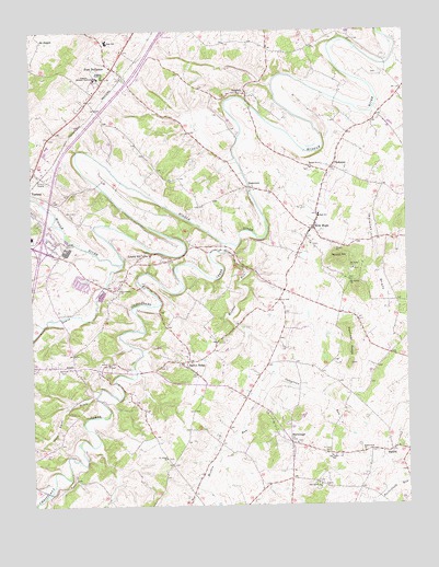
Fort Defiance, VA USGS Topographic Map
Click on map above to begin viewing in our Map Viewer.

This topographic map contains these locations and features:
Feature Name Type Latitude Longitude GNIS ID View Map
AnnexPopulated PlaceN38.1612°W78.9856°1494812View Map
Asbury ChurchChurchN38.1621°W78.9739°1462577View Map
Augusta Military Academy (historical)SchoolN38.2376°W78.9770°1462614View Map
Augusta Stone ChurchChurchN38.2382°W78.9756°1462615View Map
Barren RidgePopulated PlaceN38.1626°W78.9500°1494822View Map
Barren Ridge School (historical)SchoolN38.1629°W78.9464°1739584View Map
Belmont CemeteryCemeteryN38.1615°W78.9897°1463060View Map
Centennial School (historical)SchoolN38.2449°W78.9159°1739590View Map
Christians CreekStreamN38.1940°W78.9345°1482532View Map
Clymore Elementary SchoolSchoolN38.2462°W78.9763°2498583View Map
Coleytown RunStreamN38.1590°W78.9195°1465107View Map
DamtownPopulated PlaceN38.2085°W78.9253°1494898View Map
Fort DefiancePopulated PlaceN38.2404°W78.9720°1494937View Map
Fort Defiance High SchoolSchoolN38.2471°W78.9738°1739605View Map
Full Gospel ChurchChurchN38.1815°W78.9703°1466916View Map
HermitagePopulated PlaceN38.1415°W78.9142°1477409View Map
Hildebrand CemeteryCemeteryN38.1382°W78.8897°1739614View Map
Hildebrand ChurchChurchN38.1387°W78.8897°1468043View Map
Interchange 227CrossingN38.1929°W78.9967°1739627View Map
Kennedy RidgeRidgeN38.1671°W78.8934°1468953View Map
KnightlyPopulated PlaceN38.2335°W78.9278°1495019View Map
Laurel HillPopulated PlaceN38.1910°W78.9620°1495023View Map
Laurel Hill Baptist ChurchChurchN38.1910°W78.9603°1739632View Map
Lewis CreekStreamN38.1887°W78.9692°1484784View Map
MadridPopulated PlaceN38.1396°W78.8806°1470009View Map
Meadow RunStreamN38.1924°W78.9347°1485345View Map
Middle River ChurchChurchN38.2137°W78.9070°1470417View Map
Mount Bethel ChurchChurchN38.1871°W78.8925°1470813View Map
Mount Tabor ChurchChurchN38.1874°W78.8925°1471082View Map
New HopePopulated PlaceN38.1979°W78.9059°1495073View Map
New Hope Census Designated PlaceCensusN38.1954°W78.9044°2584892View Map
New Hope Elementary SchoolSchoolN38.2012°W78.9039°1739650View Map
New Hope Post OfficePost OfficeN38.1988°W78.9054°2766400View Map
New Hope United Methodist ChurchChurchN38.1937°W78.9067°1739651View Map
New Hope Volunteer Fire Department Company 18BuildingN38.2015°W78.9039°2075614View Map
North Point FarmLocaleN38.1497°W78.8933°2675429View Map
Oak Grove ChurchChurchN38.1304°W78.9045°1471731View Map
Oak Grove SchoolSchoolN38.1379°W78.9006°1471745View Map
PiedmontPopulated PlaceN38.2140°W78.8992°1495091View Map
Polecat DraftValleyN38.2273°W78.8835°1472586View Map
Poor Farm DraftValleyN38.1542°W78.9795°1472607View Map
Root FieldAirportN38.1730°W78.9679°2675603View Map
Rough HillSummitN38.1474°W78.9136°1477059View Map
Round HillSummitN38.1896°W78.8972°1495113View Map
Round Hill School (historical)SchoolN38.1843°W78.8939°1739662View Map
S Gordon Stewart Middle SchoolSchoolN38.2440°W78.9763°2498577View Map
Saint James ChurchChurchN38.1376°W78.9553°1473744View Map
Saint Paul CemeteryCemeteryN38.1385°W78.9006°1473856View Map
Verona Elementary SchoolSchoolN38.2198°W78.9939°2498621View Map

Note: Coordinates in the location and feature list above are referenced to NAD83 datum.


Copyright (C) 2008-2024 Ryan Niemi / Sunset Dynamics ... All Rights Reserved