TopoQuest Logo
Do you find TopoQuest useful?
Help keep TopoQuest running and adding new maps/features by donating!
Bitcoin:  19c7KJd3qBynnjoSw5npx9KScwjBe4ifkT
Litecoin:  LXs6TkuXGGXo1vDsWCkWVdjQX94eUKd6ui
Home View Maps Find Maps Find Places Resources & Links


Stuarts Draft, Virginia Topographic Map

USGS Map Title: Stuarts Draft, VA
USGS Map MRC: 38079A1
DRG (GeoTIFF) Download: o38079a1.tif


Neighboring USGS Topographic Map Quads:


  Churchville, VA  
38079B2
 

  Staunton, VA  
38079B1
 

  Fort Defiance, VA  
38078B8
 

  Greenville, VA  
38079A2
 

  Stuarts Draft, VA  
38079A1
 

  Waynesboro West, VA  
38078A8
 

  Vesuvius, VA  
37079H2
 

  Big Levels, VA  
37079H1
 

  Sherando, VA  
37078H8


Map MRC Location:

N39°
W80°
N39°
W79°
H8 H7 H6 H5 H4 H3 H2 H1
G8 G7 G6 G5 G4 G3 G2 G1
F8 F7 F6 F5 F4 F3 F2 F1
E8 E7 E6 E5 E4 E3 E2 E1
D8 D7 D6 D5 D4 D3 D2 D1
C8 C7 C6 C5 C4 C3 C2 C1
B8 B7 B6 B5 B4 B3 B2 B1
A8 A7 A6 A5 A4 A3 A2 A1
N38°
W80°
N38°
W79°

Stuarts Draft, VA USGS 1:24K Topographic Map Preview:
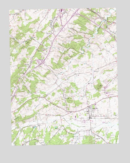
Stuarts Draft, VA USGS Topographic Map
Click on map above to begin viewing in our Map Viewer.

This topographic map contains these locations and features:
Feature Name Type Latitude Longitude GNIS ID View Map
AvisPopulated PlaceN38.0435°W79.0939°1739583View Map
BarterbrookPopulated PlaceN38.0668°W79.0270°1499093View Map
Barterbrook BranchStreamN38.0915°W79.0317°1481478View Map
Beverly Manor ChurchChurchN38.1207°W79.0222°1481685View Map
BrandPopulated PlaceN38.1154°W79.0167°1499156View Map
Broadmoor Plaza Shopping CenterLocaleN38.0365°W79.0267°1739587View Map
BrookwoodPopulated PlaceN38.0776°W79.0892°1499167View Map
Calvary ChurchChurchN38.0301°W79.0556°1482237View Map
Castles Chapel (historical)ChurchN38.1162°W79.0206°1739589View Map
Chestnut RidgeRidgeN38.0901°W79.1084°1482500View Map
Cochran ChurchChurchN38.0862°W79.0898°1482613View Map
Coles RunStreamN38.0182°W79.0034°1482644View Map
Deep Pond RunStreamN38.0046°W79.1217°1482970View Map
Falling Rock CreekStreamN38.0043°W79.0478°1483353View Map
Finley Memorial ChurchChurchN38.0287°W79.0347°1483418View Map
Folly MillsPopulated PlaceN38.0985°W79.0986°1499431View Map
Folly Mills CreekStreamN38.0840°W79.0409°1483470View Map
Good Shepherd ChurchChurchN38.1021°W79.0761°1483692View Map
Goose CreekStreamN38.1129°W79.0114°1483708View Map
Grace ChurchChurchN38.0460°W79.0831°1483730View Map
Greenmonte ChurchChurchN38.0021°W79.0911°1483822View Map
Guy K Stump Elementary SchoolSchoolN38.0300°W79.0349°2498609View Map
Hammond ChurchChurchN38.1054°W79.0495°1483920View Map
Hattons ChurchChurchN38.0135°W79.0692°1483970View Map
Hattons PondLakeN38.0162°W79.0732°1483971View Map
Interchange 217CrossingN38.0762°W79.0873°1739622View Map
Interchange 220CrossingN38.1082°W79.0623°1739623View Map
Interchange 221CrossingN38.1210°W79.0470°1739624View Map
Johns RunStreamN38.0157°W79.0456°1484474View Map
JolivuePopulated PlaceN38.1099°W79.0731°1499610View Map
Jolivue Census Designated PlaceCensusN38.1150°W79.0668°2389988View Map
Lake WildaReservoirN38.0166°W79.0975°1488366View Map
Loves RunStreamN38.0218°W79.0823°1485103View Map
Mint SpringPopulated PlaceN38.0746°W79.1009°1499751View Map
Mint Spring Post OfficePost OfficeN38.0655°W79.1093°2766392View Map
Mint Spring United Methodist ChurchChurchN38.0726°W79.1039°1739640View Map
Oak Grove ChurchChurchN38.1207°W79.1164°1485937View Map
Pilgrim Christian SchoolSchoolN38.0477°W79.0477°2498616View Map
Pine RunStreamN38.0165°W79.1136°1486228View Map
Reeds ChapelChurchN38.0343°W79.0345°1486559View Map
RivermontPopulated PlaceN38.0087°W79.0272°1499967View Map
Round HillSummitN38.0529°W79.0206°1486784View Map
Schneider Community ParkParkN38.0246°W79.0297°1739664View Map
Shenandoah Valley EstatesPopulated PlaceN38.0521°W79.0131°1739666View Map
South River Number Seven DamDamN38.0185°W79.0964°1489201View Map
Spring Valley ChurchChurchN38.0026°W79.1073°1487467View Map
Staunton Mall Shopping CenterLocaleN38.1240°W79.0634°1739668View Map
Stony RunStreamN38.0182°W79.0514°1487637View Map
Stuarts DraftPopulated PlaceN38.0301°W79.0336°1500184View Map
Stuarts Draft Census Designated PlaceCensusN38.0245°W79.0309°2390367View Map
Stuarts Draft Elementary SchoolSchoolN38.0473°W79.0078°1483293View Map
Stuarts Draft High SchoolSchoolN38.0466°W79.0129°1488524View Map
Stuarts Draft Middle SchoolSchoolN38.0449°W79.0099°1488669View Map
Stuarts Draft Post OfficePost OfficeN38.0366°W79.0263°2766304View Map
Stuarts Draft Rescue Squad Rescue 6BuildingN38.0319°W79.0351°2075623View Map
Stuarts Draft Volunteer Fire Department Company 7BuildingN38.0308°W79.0338°2075605View Map
Valley View ChurchChurchN38.0087°W79.0253°1739676View Map
White HillPopulated PlaceN38.0435°W79.0628°1500309View Map
WildaPopulated PlaceN38.0182°W79.0934°1500317View Map
Windmill Square Shopping CenterLocaleN38.0335°W79.0400°1739684View Map

Note: Coordinates in the location and feature list above are referenced to NAD83 datum.


Copyright (C) 2008-2024 Ryan Niemi / Sunset Dynamics ... All Rights Reserved