TopoQuest Logo
Do you find TopoQuest useful?
Help keep TopoQuest running and adding new maps/features by donating!
Bitcoin:  19c7KJd3qBynnjoSw5npx9KScwjBe4ifkT
Litecoin:  LXs6TkuXGGXo1vDsWCkWVdjQX94eUKd6ui
Home View Maps Find Maps Find Places Resources & Links


Fort Gaines NE, Georgia Topographic Map

USGS Map Title: Fort Gaines NE, GA
USGS Map MRC: 31085F1
DRG (GeoTIFF) Download: o31085f1.tif


Neighboring USGS Topographic Map Quads:


  Eufaula South, AL  
31085G2
 

  Hatcher, GA  
31085G1
 

  Morris, GA  
31084G8
 

  Fort Gaines NW, AL  
31085F2
 

  Fort Gaines NE, GA  
31085F1
 

  Coleman, GA  
31084F8
 

  Abbeville East, AL  
31085E2
 

  Fort Gaines, GA  
31085E1
 

  Zetto, GA  
31084E8


Map MRC Location:

N32°
W86°
N32°
W85°
H8 H7 H6 H5 H4 H3 H2 H1
G8 G7 G6 G5 G4 G3 G2 G1
F8 F7 F6 F5 F4 F3 F2 F1
E8 E7 E6 E5 E4 E3 E2 E1
D8 D7 D6 D5 D4 D3 D2 D1
C8 C7 C6 C5 C4 C3 C2 C1
B8 B7 B6 B5 B4 B3 B2 B1
A8 A7 A6 A5 A4 A3 A2 A1
N31°
W86°
N31°
W85°

Fort Gaines NE, GA USGS 1:24K Topographic Map Preview:
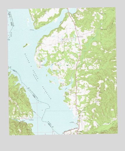
Fort Gaines NE, GA USGS Topographic Map
Click on map above to begin viewing in our Map Viewer.

This topographic map contains these locations and features:
Feature Name Type Latitude Longitude GNIS ID View Map
Campground CemeteryCemeteryN31.6560°W85.0241°312269View Map
Cannon Grove ChurchChurchN31.6666°W85.0208°312315View Map
Clay County Volunteer Fire Department Station 2BuildingN31.7227°W85.0418°2604312View Map
Cotton Hill Public Use AreaParkN31.6746°W85.0641°313008View Map
Credille Mill (historical)LocaleN31.7268°W85.0922°352248View Map
Cypress PondSwampN31.6934°W85.0567°313258View Map
Days CrossroadsPopulated PlaceN31.7218°W85.0441°355457View Map
East Bank Public Use AreaParkN31.6371°W85.0497°313767View Map
Emanuel ChurchChurchN31.7204°W85.0466°344809View Map
Fairview School (historical)SchoolN31.7310°W85.0055°344811View Map
Fort Gaines DivisionCivilN31.6962°W85.0292°1936273View Map
George T Bagby State ParkParkN31.7382°W85.0694°344820View Map
Hardridge CreekStreamN31.6385°W85.0983°119723View Map
Hardridge Creek Public Use AreaParkN31.6407°W85.1022°119724View Map
Hartley PondLakeN31.7190°W85.0629°315216View Map
Highland Park Public Use AreaParkN31.6313°W85.0997°120080View Map
Johnny Moore HillSummitN31.7338°W85.0027°332105View Map
Macedonia ChurchChurchN31.6979°W85.0877°317531View Map
Moores CrossroadsPopulated PlaceN31.7446°W85.0171°326404View Map
Mount Gilead CemeteryCemeteryN31.6779°W85.0083°344826View Map
Mount Gilead ChurchChurchN31.6785°W85.0085°318639View Map
Mount Zion ChurchChurchN31.6474°W85.0424°318953View Map
New Hope ChurchChurchN31.7471°W85.0799°319378View Map
New Lowell CemeteryCemeteryN31.7299°W85.0916°344829View Map
New Lowell ChurchChurchN31.7302°W85.0910°319473View Map
Ocean PondLakeN31.6941°W85.0649°319883View Map
Oketeyeconne (historical)Populated PlaceN31.6432°W85.0805°344832View Map
Old Camp Ground Church (historical)ChurchN31.6568°W85.0246°344833View Map
Otho BranchStreamN31.6910°W85.1216°124319View Map
Pataula CreekStreamN31.7299°W85.1169°320256View Map
Pataula Creek Public Use AreaParkN31.7343°W85.0805°320257View Map
Saint Peters ChurchChurchN31.6777°W85.0466°322294View Map
Sandy BranchStreamN31.6896°W85.0838°322462View Map
Sandy Branch Public Use AreaParkN31.6929°W85.0866°322464View Map
Sandy CreekStreamN31.6671°W85.0641°322472View Map
Sandy Creek Public Use AreaParkN31.6652°W85.0599°322477View Map
Screamer Volunteer Fire Department Station 2BuildingN31.6531°W85.1140°2691527View Map
Standleys StoreLocaleN31.7154°W85.0894°323506View Map
Walter F George ReservoirReservoirN31.6548°W85.0864°324814View Map
Watson CrossroadsPopulated PlaceN31.7296°W85.0177°326581View Map

Note: Coordinates in the location and feature list above are referenced to NAD83 datum.


Copyright (C) 2008-2025 Ryan Niemi / Sunset Dynamics ... All Rights Reserved