TopoQuest Logo
Do you find TopoQuest useful?
Help keep TopoQuest running and adding new maps/features by donating!
Bitcoin:  19c7KJd3qBynnjoSw5npx9KScwjBe4ifkT
Litecoin:  LXs6TkuXGGXo1vDsWCkWVdjQX94eUKd6ui
Home View Maps Find Maps Find Places Resources & Links


Morris, Georgia Topographic Map

USGS Map Title: Morris, GA
USGS Map MRC: 31084G8
DRG (GeoTIFF) Download: o31084g8.tif


Neighboring USGS Topographic Map Quads:


  Georgetown, GA  
31085H1
 

  Sanford, GA  
31084H8
 

  County Line, GA  
31084H7
 

  Hatcher, GA  
31085G1
 

  Morris, GA  
31084G8
 

  Cuthbert, GA  
31084G7
 

  Fort Gaines NE, GA  
31085F1
 

  Coleman, GA  
31084F8
 

  Carnegie, GA  
31084F7


Map MRC Location:

N32°
W85°
N32°
W84°
H8 H7 H6 H5 H4 H3 H2 H1
G8 G7 G6 G5 G4 G3 G2 G1
F8 F7 F6 F5 F4 F3 F2 F1
E8 E7 E6 E5 E4 E3 E2 E1
D8 D7 D6 D5 D4 D3 D2 D1
C8 C7 C6 C5 C4 C3 C2 C1
B8 B7 B6 B5 B4 B3 B2 B1
A8 A7 A6 A5 A4 A3 A2 A1
N31°
W85°
N31°
W84°

Morris, GA USGS 1:24K Topographic Map Preview:
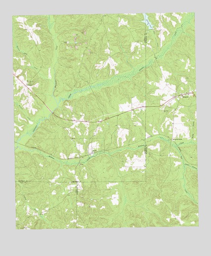
Morris, GA USGS Topographic Map
Click on map above to begin viewing in our Map Viewer.

This topographic map contains these locations and features:
Feature Name Type Latitude Longitude GNIS ID View Map
Bethel ChurchChurchN31.8249°W84.8896°344719View Map
CrossroadsPopulated PlaceN31.8343°W84.9910°326239View Map
Deer CreekStreamN31.8502°W84.8996°313420View Map
Enon Church (historical)ChurchN31.8313°W84.9874°350537View Map
Hodchodkee CreekStreamN31.8266°W84.9716°315479View Map
Hog CreekStreamN31.7963°W84.8888°315503View Map
Holanna CreekStreamN31.7971°W84.9927°315528View Map
Hunt BranchStreamN31.7593°W84.9269°344742View Map
Kitchen BranchStreamN31.7666°W84.9244°344741View Map
Mill BranchStreamN31.8010°W84.9058°352241View Map
MorrisPopulated PlaceN31.7943°W84.9463°332421View Map
Morris Baptist ChurchChurchN31.7952°W84.9471°350544View Map
Mount Zion ChurchChurchN31.8363°W84.9891°318959View Map
Muddy BranchStreamN31.8007°W84.8788°319129View Map
Old Bethel Church (historical)ChurchN31.8210°W84.9066°344751View Map
Owon BranchStreamN31.8693°W84.8791°344752View Map
Parker BranchStreamN31.8543°W84.8938°344753View Map
Perkins Lookout TowerTowerN31.7510°W84.9924°344314View Map
Phillips PondReservoirN31.8739°W84.9086°337472View Map
Phillips Pond DamDamN31.8660°W84.9046°337471View Map
Randolph County Fire Department Springvale StationBuildingN31.8276°W84.8803°2604429View Map
Saint Johns ChurchChurchN31.8024°W84.9608°322117View Map
Short CreekStreamN31.7941°W84.9369°350552View Map
Smithee Jack CreekStreamN31.8363°W84.9741°323155View Map
SpringvalePopulated PlaceN31.8282°W84.8796°323479View Map
Springvale Baptist ChurchChurchN31.8277°W84.8796°344771View Map
Springvale CemeteryCemeteryN31.8177°W84.8977°323480View Map
Springvale Methodist ChurchChurchN31.8279°W84.8805°344773View Map
Springvale StationLocaleN31.8018°W84.8921°323482View Map
Taylor BranchStreamN31.7866°W84.8835°323941View Map
Wildcat CreekStreamN31.8132°W84.9858°325273View Map

Note: Coordinates in the location and feature list above are referenced to NAD83 datum.


Copyright (C) 2008-2025 Ryan Niemi / Sunset Dynamics ... All Rights Reserved