TopoQuest Logo
Do you find TopoQuest useful?
Help keep TopoQuest running and adding new maps/features by donating!
Bitcoin:  19c7KJd3qBynnjoSw5npx9KScwjBe4ifkT
Litecoin:  LXs6TkuXGGXo1vDsWCkWVdjQX94eUKd6ui
Home View Maps Find Maps Find Places Resources & Links


Fort Lonesome, Florida Topographic Map

USGS Map Title: Fort Lonesome, FL
USGS Map MRC: 27082F2
DRG (GeoTIFF) Download: o27082f2.tif


Neighboring USGS Topographic Map Quads:


  Riverview, FL  
27082G3
 

  Lithia, FL  
27082G2
 

  Keysville, FL  
27082G1
 

  Wimauma, FL  
27082F3
 

  Fort Lonesome, FL  
27082F2
 

  Duette NE, FL  
27082F1
 

  Rye, FL  
27082E3
 

  Keentown, FL  
27082E2
 

  Duette, FL  
27082E1


Map MRC Location:

N28°
W83°
N28°
W82°
H8 H7 H6 H5 H4 H3 H2 H1
G8 G7 G6 G5 G4 G3 G2 G1
F8 F7 F6 F5 F4 F3 F2 F1
E8 E7 E6 E5 E4 E3 E2 E1
D8 D7 D6 D5 D4 D3 D2 D1
C8 C7 C6 C5 C4 C3 C2 C1
B8 B7 B6 B5 B4 B3 B2 B1
A8 A7 A6 A5 A4 A3 A2 A1
N27°
W83°
N27°
W82°

Fort Lonesome, FL USGS 1:24K Topographic Map Preview:
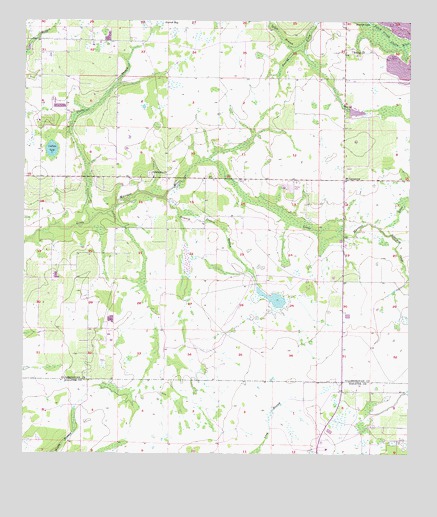
Fort Lonesome, FL USGS Topographic Map
Click on map above to begin viewing in our Map Viewer.

This topographic map contains these locations and features:
Feature Name Type Latitude Longitude GNIS ID View Map
Alderman CreekStreamN27.6903°W82.1343°277736View Map
Alderman-Carlton RanchettesPopulated PlaceN27.7323°W82.2405°2482157View Map
Carlton LakePopulated PlaceN27.7160°W82.2424°2482725View Map
Carlton LakeLakeN27.7130°W82.2410°280043View Map
Carter CountryPopulated PlaceN27.7198°W82.2383°2482760View Map
Clark FarmsPopulated PlaceN27.7424°W82.2340°2482851View Map
Fellowship ChurchChurchN27.7050°W82.2073°282408View Map
Fort LonesomePopulated PlaceN27.7048°W82.1459°294778View Map
Gyro Town USA AirportAirportN27.6839°W82.2318°2676645View Map
Hiscock AcresPopulated PlaceN27.7307°W82.1483°2483535View Map
Howard Prairie BranchStreamN27.6989°W82.2040°284348View Map
Hurrah ChurchChurchN27.7417°W82.1434°284417View Map
Hurrah Fire TowerTowerN27.7411°W82.1454°300126View Map
Lewis BranchStreamN27.7425°W82.1620°285487View Map
Lonesome HollowPopulated PlaceN27.6692°W82.2347°2483088View Map
Pierce BranchStreamN27.6920°W82.2284°288793View Map
Seth Country TractsPopulated PlaceN27.7398°W82.2304°2484897View Map
Summerfield Wimauma EstatesPopulated PlaceN27.6999°W82.2471°2485096View Map
Tatom EstatesPopulated PlaceN27.7466°W82.2411°2485190View Map
Watts JunctionPopulated PlaceN27.7403°W82.2466°2484636View Map

Note: Coordinates in the location and feature list above are referenced to NAD83 datum.


Copyright (C) 2008-2025 Ryan Niemi / Sunset Dynamics ... All Rights Reserved