TopoQuest Logo
Do you find TopoQuest useful?
Help keep TopoQuest running and adding new maps/features by donating!
Bitcoin:  19c7KJd3qBynnjoSw5npx9KScwjBe4ifkT
Litecoin:  LXs6TkuXGGXo1vDsWCkWVdjQX94eUKd6ui
Home View Maps Find Maps Find Places Resources & Links


Keysville, Florida Topographic Map

USGS Map Title: Keysville, FL
USGS Map MRC: 27082G1
DRG (GeoTIFF) Download: o27082g1.tif


Neighboring USGS Topographic Map Quads:


  Dover, FL  
27082H2
 

  Nichols, FL  
27082H1
 

  Mulberry, FL  
27081H8
 

  Lithia, FL  
27082G2
 

  Keysville, FL  
27082G1
 

  Bradley Junction, FL  
27081G8
 

  Fort Lonesome, FL  
27082F2
 

  Duette NE, FL  
27082F1
 

  Baird, FL  
27081F8


Map MRC Location:

N28°
W83°
N28°
W82°
H8 H7 H6 H5 H4 H3 H2 H1
G8 G7 G6 G5 G4 G3 G2 G1
F8 F7 F6 F5 F4 F3 F2 F1
E8 E7 E6 E5 E4 E3 E2 E1
D8 D7 D6 D5 D4 D3 D2 D1
C8 C7 C6 C5 C4 C3 C2 C1
B8 B7 B6 B5 B4 B3 B2 B1
A8 A7 A6 A5 A4 A3 A2 A1
N27°
W83°
N27°
W82°

Keysville, FL USGS 1:24K Topographic Map Preview:
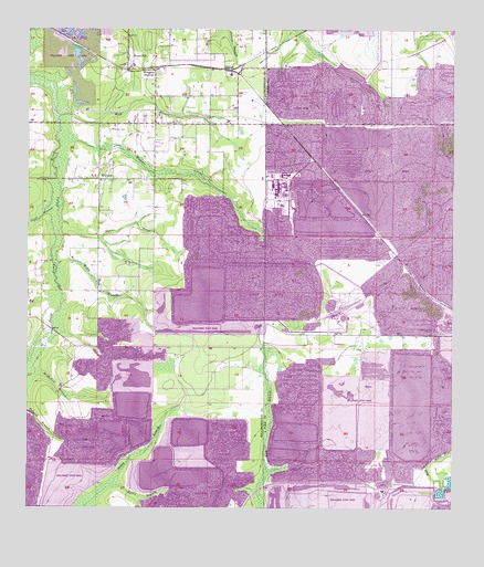
Keysville, FL USGS Topographic Map
Click on map above to begin viewing in our Map Viewer.

This topographic map contains these locations and features:
Feature Name Type Latitude Longitude GNIS ID View Map
Alafia RanchPopulated PlaceN27.8472°W82.1058°2482148View Map
Alafia River State ParkParkN27.8600°W82.1206°1946048View Map
Beulah ChurchChurchN27.8659°W82.0484°278586View Map
Blue CemeteryCemeteryN27.8550°W82.0784°279011View Map
Chito BranchStreamN27.8297°W82.1148°280407View Map
Cindy Lynn PlacePopulated PlaceN27.8527°W82.0930°2482837View Map
Corbett AcresPopulated PlaceN27.8493°W82.0973°2482911View Map
Creightons Mizelle Creek Garden EstatesPopulated PlaceN27.8417°W82.0978°2482963View Map
EdgePopulated PlaceN27.8595°W82.0854°2482399View Map
EdisonPopulated PlaceN27.8653°W82.0665°295257View Map
Edison JunctionLocaleN27.8642°W82.0643°300119View Map
Gully BranchStreamN27.7536°W82.1040°283511View Map
Guy BranchStreamN27.8528°W82.0206°283571View Map
Halls BranchStreamN27.8142°W82.1173°283632View Map
Hunter CemeteryCemeteryN27.8489°W82.1001°284400View Map
Hunters HillPopulated PlaceN27.8485°W82.0776°2483576View Map
Jameson FarmsPopulated PlaceN27.8070°W82.1230°2483626View Map
KeysvillePopulated PlaceN27.8692°W82.0956°285093View Map
Keysville EstatesPopulated PlaceN27.8676°W82.0773°2483711View Map
Lane AcresPopulated PlaceN27.8543°W82.1226°2483860View Map
LillibridgePopulated PlaceN27.7920°W82.1095°300118View Map
Mac AcresPopulated PlaceN27.8194°W82.0944°2483129View Map
McMullen BranchGutN27.7817°W82.1159°286644View Map
Mizelle CreekStreamN27.8484°W82.1159°287023View Map
New Wales Railroad Station (historical)LocaleN27.8378°W82.0454°301441View Map
Owens BranchStreamN27.8253°W82.1156°288308View Map
RobertsPopulated PlaceN27.8534°W82.0958°2484095View Map
Rogers RanchPopulated PlaceN27.8635°W82.0758°2484112View Map
Southwood EstatesPopulated PlaceN27.8721°W82.0899°2485007View Map
WelcomePopulated PlaceN27.8361°W82.1043°293009View Map
WelcomeLocaleN27.8647°W82.0881°293010View Map
West Branch South Prong Alafia RiverStreamN27.8525°W82.1159°293044View Map
West Polk Railroad StationLocaleN27.8206°W82.0204°301442View Map

Note: Coordinates in the location and feature list above are referenced to NAD83 datum.


Copyright (C) 2008-2025 Ryan Niemi / Sunset Dynamics ... All Rights Reserved