TopoQuest Logo
Do you find TopoQuest useful?
Help keep TopoQuest running and adding new maps/features by donating!
Bitcoin:  19c7KJd3qBynnjoSw5npx9KScwjBe4ifkT
Litecoin:  LXs6TkuXGGXo1vDsWCkWVdjQX94eUKd6ui
Home View Maps Find Maps Find Places Resources & Links


Fort Stanton, New Mexico Topographic Map

USGS Map Title: Fort Stanton, NM
USGS Map MRC: 33105D5
DRG (GeoTIFF) Download: o33105d5.tif


Neighboring USGS Topographic Map Quads:


  Nogal, NM  
33105E6
 

  Capitan, NM  
33105E5
 

  Capitan Pass, NM  
33105E4
 

  Angus, NM  
33105D6
 

  Fort Stanton, NM  
33105D5
 

  Lincoln, NM  
33105D4
 

  Ruidoso, NM  
33105C6
 

  Ruidoso Downs, NM  
33105C5
 

  Sheeppen Canyon, NM  
33105C4


Map MRC Location:

N34°
W106°
N34°
W105°
H8 H7 H6 H5 H4 H3 H2 H1
G8 G7 G6 G5 G4 G3 G2 G1
F8 F7 F6 F5 F4 F3 F2 F1
E8 E7 E6 E5 E4 E3 E2 E1
D8 D7 D6 D5 D4 D3 D2 D1
C8 C7 C6 C5 C4 C3 C2 C1
B8 B7 B6 B5 B4 B3 B2 B1
A8 A7 A6 A5 A4 A3 A2 A1
N33°
W106°
N33°
W105°

Fort Stanton, NM USGS 1:24K Topographic Map Preview:
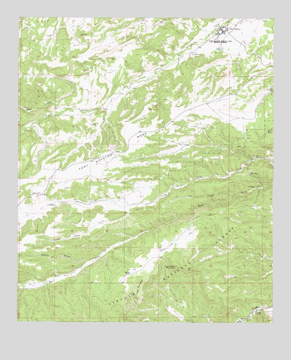
Fort Stanton, NM USGS Topographic Map
Click on map above to begin viewing in our Map Viewer.

This topographic map contains these locations and features:
Feature Name Type Latitude Longitude GNIS ID View Map
Angus PetMineN33.4440°W105.5828°915580View Map
Bitter CanyonValleyN33.4620°W105.6025°903844View Map
Bonito Volunteer Fire Department Sonterra StationBuildingN33.4329°W105.6223°2658196View Map
Buck TankReservoirN33.4365°W105.5119°904139View Map
Camp Sierra BlancaLocaleN33.4851°W105.5403°904322View Map
Camp Sierra Blanca LibraryBuildingN33.4940°W105.5228°929390View Map
Crow CanyonValleyN33.4270°W105.5205°905527View Map
Dry Eagle LakesLakeN33.4060°W105.5516°905934View Map
Dry TankReservoirN33.4829°W105.5444°913141View Map
Eagle Creek WellWellN33.4304°W105.5097°905931View Map
Eagle TankReservoirN33.4298°W105.5091°913142View Map
East TankReservoirN33.3888°W105.5412°913140View Map
Flume TankReservoirN33.4309°W105.5459°1986631View Map
Fort StantonPopulated PlaceN33.4959°W105.5230°906337View Map
Fort Stanton Historical MarkerParkN33.4959°W105.5230°932338View Map
Fort Stanton MesaSummitN33.4298°W105.6025°906338View Map
Fort Stanton Post OfficePost OfficeN33.4965°W105.5249°938478View Map
Fort Stanton Volunteer Fire DepartmentBuildingN33.4933°W105.5283°2657578View Map
Fort Stanton Weather StationLocaleN33.4959°W105.5230°931823View Map
Four K RanchLocaleN33.4276°W105.6139°906351View Map
Fox CaveLocaleN33.3770°W105.5150°1986636View Map
Goat MountainSummitN33.3904°W105.5641°906585View Map
Harlan TankReservoirN33.3952°W105.5703°906847View Map
Hightower MountainSummitN33.3976°W105.5475°906981View Map
Hunters DrawValleyN33.4223°W105.5711°907170View Map
Lincoln HillsRangeN33.4148°W105.6150°899284View Map
Little SpringSpringN33.4241°W105.5600°913138View Map
Lone Pine TankReservoirN33.4064°W105.5203°913139View Map
Pine CanyonValleyN33.4170°W105.6208°909656View Map
Pine TankReservoirN33.4266°W105.5419°913146View Map
Red Ketchum WindmillLocaleN33.4429°W105.5066°910067View Map
Road TankReservoirN33.4151°W105.5402°913144View Map
Rock TankReservoirN33.4273°W105.5335°913147View Map
Ruidoso DivisionCivilN33.3772°W105.5952°1937580View Map
San Ysidro Church and CemeteryChurchN33.3795°W105.5094°910714View Map
Sawmill CanyonValleyN33.4001°W105.5905°910833View Map
Sierra BlancaRangeN33.4226°W105.5819°1986633View Map
Sierra Blanca Regional AirportAirportN33.4618°W105.5317°937014View Map
Spur TankReservoirN33.4400°W105.5370°913150View Map
Stanton TankReservoirN33.4509°W105.5139°913149View Map
Sweethart WindmillReservoirN33.3973°W105.5003°913335View Map
Trick TankReservoirN33.3981°W105.5183°1986635View Map
Turkey TankReservoirN33.3849°W105.5944°913137View Map
Twin TankReservoirN33.3892°W105.5531°913136View Map
West Silver TankReservoirN33.4166°W105.5179°913143View Map
West Spur TankReservoirN33.4961°W105.6048°913148View Map
West TankReservoirN33.3962°W105.5322°1986634View Map
West TankReservoirN33.4542°W105.5036°912263View Map

Note: Coordinates in the location and feature list above are referenced to NAD83 datum.


Copyright (C) 2008-2025 Ryan Niemi / Sunset Dynamics ... All Rights Reserved