TopoQuest Logo
Do you find TopoQuest useful?
Help keep TopoQuest running and adding new maps/features by donating!
Bitcoin:  19c7KJd3qBynnjoSw5npx9KScwjBe4ifkT
Litecoin:  LXs6TkuXGGXo1vDsWCkWVdjQX94eUKd6ui
Home View Maps Find Maps Find Places Resources & Links


Fortress Cliff, Texas Topographic Map

USGS Map Title: Fortress Cliff, TX
USGS Map MRC: 34101H6
DRG (GeoTIFF) Download: o34101h6.tif


Neighboring USGS Topographic Map Quads:


  The Palisades, TX  
35101A7
 

  Thomas Ranch, TX  
35101A6
 

  Fairview, TX  
35101A5
 

  Nance Ranch, TX  
34101H7
 

  Fortress Cliff, TX  
34101H6
 

  Pony Flats, TX  
34101H5
 

  Canyon SE, TX  
34101G7
 

  Wesley Point, TX  
34101G6
 

  Wayside, TX  
34101G5


Map MRC Location:

N35°
W102°
N35°
W101°
H8 H7 H6 H5 H4 H3 H2 H1
G8 G7 G6 G5 G4 G3 G2 G1
F8 F7 F6 F5 F4 F3 F2 F1
E8 E7 E6 E5 E4 E3 E2 E1
D8 D7 D6 D5 D4 D3 D2 D1
C8 C7 C6 C5 C4 C3 C2 C1
B8 B7 B6 B5 B4 B3 B2 B1
A8 A7 A6 A5 A4 A3 A2 A1
N34°
W102°
N34°
W101°

Fortress Cliff, TX USGS 1:24K Topographic Map Preview:
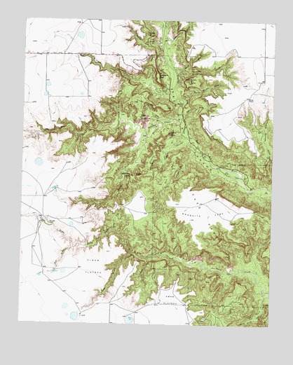
Fortress Cliff, TX USGS Topographic Map
Click on map above to begin viewing in our Map Viewer.

This topographic map contains these locations and features:
Feature Name Type Latitude Longitude GNIS ID View Map
Brushy ButteSummitN34.9756°W101.6677°1353024View Map
Brushy DrawValleyN34.9782°W101.6738°1353064View Map
Bull DrawValleyN34.9067°W101.7241°1353240View Map
Burnt DrawValleyN34.9596°W101.6701°1353369View Map
Capitol MesaSummitN34.9467°W101.6849°1353794View Map
Capitol PeakSummitN34.9534°W101.6763°1353795View Map
Capitol Peak CanyonValleyN34.9509°W101.6691°1353796View Map
Castle PeakSummitN34.9367°W101.6938°1353943View Map
Cooley ButteSummitN34.9945°W101.6888°1354914View Map
Cooley DrawValleyN34.9911°W101.6816°1354915View Map
Corral DrawValleyN34.9071°W101.7240°1355027View Map
Devils TombstonePillarN34.9603°W101.6918°1355982View Map
Elbow PlateauPlainN34.8984°W101.7135°1356887View Map
Fortress CliffCliffN34.9534°W101.6577°1357602View Map
Goodnight PeakSummitN34.9773°W101.6830°1358165View Map
Judys ArchArchN34.9325°W101.6450°2678380View Map
Krahn RanchLocaleN34.9684°W101.6380°1360763View Map
Lighthouse PeakSummitN34.9364°W101.6968°1361185View Map
Little Sunday CreekStreamN34.9526°W101.6882°1361483View Map
Long DrawValleyN34.9040°W101.6944°1361725View Map
Mesquite ParkParkN34.9212°W101.6585°1362657View Map
North Cita CanyonValleyN34.8872°W101.6279°1364018View Map
North Cita CreekStreamN34.8884°W101.6255°1364019View Map
North Spur ValleyValleyN34.9799°W101.6754°1364141View Map
Palo Duro Canyon State Park TrailTrailN34.9492°W101.6657°2033262View Map
Palo Duro State ParkParkN34.9334°W101.6624°1375342View Map
Pin DrawValleyN34.9025°W101.6869°1365246View Map
Red CanyonValleyN34.9450°W101.6635°1366139View Map
Red MesaSummitN34.9326°W101.6802°1366181View Map
Reynolds RanchLocaleN34.9162°W101.7363°1366391View Map
Rustlers DrawValleyN34.9600°W101.6825°1367052View Map
Seep CanyonValleyN34.9923°W101.6806°1367934View Map
South Brushy DrawValleyN34.9684°W101.6710°1368645View Map
South Cita CanyonValleyN34.8872°W101.6276°1376193View Map
South Cita CreekStreamN34.8876°W101.6277°1368659View Map
Sunday CreekStreamN34.9581°W101.6699°1376340View Map
Sunday FlatsFlatN34.9578°W101.6818°1369395View Map
Swan PlateauPlainN34.8853°W101.6746°1369448View Map
Timber CreekStreamN34.9698°W101.6766°1376463View Map
Timber MesaSummitN34.9664°W101.6949°1369952View Map
Tub SpringsSpringN34.9584°W101.6421°1998401View Map
Tub Springs DrawValleyN34.9303°W101.6253°1370175View Map
Woody DrawValleyN34.9137°W101.7036°1371943View Map

Note: Coordinates in the location and feature list above are referenced to NAD83 datum.


Copyright (C) 2008-2025 Ryan Niemi / Sunset Dynamics ... All Rights Reserved