TopoQuest Logo
Do you find TopoQuest useful?
Help keep TopoQuest running and adding new maps/features by donating!
Bitcoin:  19c7KJd3qBynnjoSw5npx9KScwjBe4ifkT
Litecoin:  LXs6TkuXGGXo1vDsWCkWVdjQX94eUKd6ui
Home View Maps Find Maps Find Places Resources & Links


Fountain Springs, California Topographic Map

USGS Map Title: Fountain Springs, CA
USGS Map MRC: 35118H8
DRG (GeoTIFF) Download: o35118h8.tif


Neighboring USGS Topographic Map Quads:


  Porterville, CA  
36119A1
 

  Success Dam, CA  
36118A8
 

  Globe, CA  
36118A7
 

  Ducor, CA  
35119H1
 

  Fountain Springs, CA  
35118H8
 

  Gibbon Peak, CA  
35118H7
 

  Richgrove, CA  
35119G1
 

  Quincy School, CA  
35118G8
 

  White River, CA  
35118G7


Map MRC Location:

N36°
W119°
N36°
W118°
H8 H7 H6 H5 H4 H3 H2 H1
G8 G7 G6 G5 G4 G3 G2 G1
F8 F7 F6 F5 F4 F3 F2 F1
E8 E7 E6 E5 E4 E3 E2 E1
D8 D7 D6 D5 D4 D3 D2 D1
C8 C7 C6 C5 C4 C3 C2 C1
B8 B7 B6 B5 B4 B3 B2 B1
A8 A7 A6 A5 A4 A3 A2 A1
N35°
W119°
N35°
W118°

Fountain Springs, CA USGS 1:24K Topographic Map Preview:
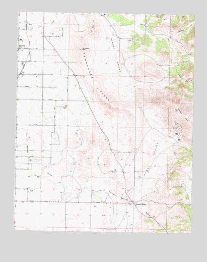
Fountain Springs, CA USGS Topographic Map
Click on map above to begin viewing in our Map Viewer.

This topographic map contains these locations and features:
Feature Name Type Latitude Longitude GNIS ID View Map
Dennis RanchLocaleN35.8983°W118.9898°241417View Map
Fountain SpringsPopulated PlaceN35.8911°W118.9157°1656522View Map
Good Shepherd Lutheran Home for the RetardedBuildingN35.9838°W118.9984°1835757View Map
Grandview School (historical)SchoolN35.9494°W118.9676°1670255View Map
Hewey ValleyValleyN35.8944°W118.9268°243394View Map
Hungry HollowValleyN35.9961°W118.9351°243734View Map
Hungry Hollow Borrow PitMineN35.9681°W118.9272°2677940View Map
Hunsaker Borrow Pit Number 2MineN35.8933°W118.9389°2678016View Map
Hunsaker QuarryMineN35.8886°W118.9389°2678015View Map
Lempon (historical)Populated PlaceN35.9988°W118.9948°1670256View Map
Muller Borrow PitMineN35.8967°W118.9300°2680986View Map
Pratt RanchLocaleN35.9866°W118.9323°1670257View Map
Quedow MountainSummitN35.9386°W118.8801°273154View Map
Tennessee KnobSummitN35.9788°W118.9554°250338View Map
Tennessee RidgeRidgeN35.9572°W118.9448°250339View Map
Terra Bella DivisionCivilN35.8808°W118.9866°1935338View Map
UltraPopulated PlaceN35.9641°W118.9984°250780View Map
Zion Lutheran SchoolSchoolN35.9779°W118.9997°1835796View Map
Zumwalt Ranch (historical)LocaleN35.9844°W118.8926°1670258View Map

Note: Coordinates in the location and feature list above are referenced to NAD83 datum.


Copyright (C) 2008-2025 Ryan Niemi / Sunset Dynamics ... All Rights Reserved