TopoQuest Logo
Do you find TopoQuest useful?
Help keep TopoQuest running and adding new maps/features by donating!
Bitcoin:  19c7KJd3qBynnjoSw5npx9KScwjBe4ifkT
Litecoin:  LXs6TkuXGGXo1vDsWCkWVdjQX94eUKd6ui
Home View Maps Find Maps Find Places Resources & Links


Success Dam, California Topographic Map

USGS Map Title: Success Dam, CA
USGS Map MRC: 36118A8
DRG (GeoTIFF) Download: o36118a8.tif


Neighboring USGS Topographic Map Quads:


  Lindsay, CA  
36119B1
 

  Frazier Valley, CA  
36118B8
 

  Springville, CA  
36118B7
 

  Porterville, CA  
36119A1
 

  Success Dam, CA  
36118A8
 

  Globe, CA  
36118A7
 

  Ducor, CA  
35119H1
 

  Fountain Springs, CA  
35118H8
 

  Gibbon Peak, CA  
35118H7


Map MRC Location:

N37°
W119°
N37°
W118°
H8 H7 H6 H5 H4 H3 H2 H1
G8 G7 G6 G5 G4 G3 G2 G1
F8 F7 F6 F5 F4 F3 F2 F1
E8 E7 E6 E5 E4 E3 E2 E1
D8 D7 D6 D5 D4 D3 D2 D1
C8 C7 C6 C5 C4 C3 C2 C1
B8 B7 B6 B5 B4 B3 B2 B1
A8 A7 A6 A5 A4 A3 A2 A1
N36°
W119°
N36°
W118°

Success Dam, CA USGS 1:24K Topographic Map Preview:
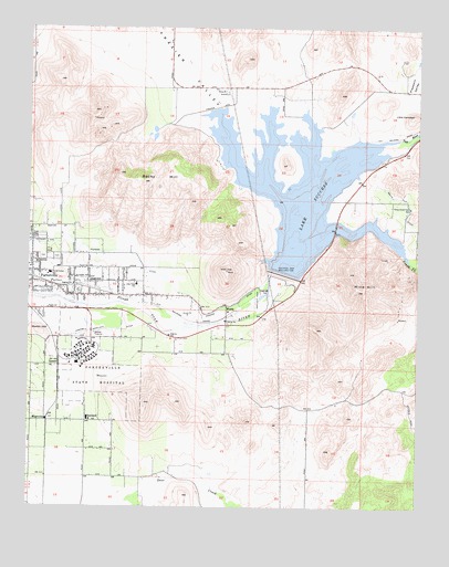
Success Dam, CA USGS Topographic Map
Click on map above to begin viewing in our Map Viewer.

This topographic map contains these locations and features:
Feature Name Type Latitude Longitude GNIS ID View Map
Alta Vista (historical)Populated PlaceN36.0550°W118.9640°1835742View Map
Alta Vista Elementary SchoolSchoolN36.0586°W118.9659°238560View Map
Assembly of God Neighborhood ChurchChurchN36.0575°W118.9857°1835745View Map
Bartlett ParkParkN36.0555°W118.9265°239020View Map
Campbell-Moreland DitchCanalN36.0458°W118.9907°240125View Map
Citrus-South Tule Elementary SchoolSchoolN36.0780°W118.8782°240638View Map
Deer Creek MineMineN36.0050°W118.9539°2711768View Map
East PortervillePopulated PlaceN36.0575°W118.9757°1867018View Map
East Porterville Census Designated PlaceCensusN36.0573°W118.9713°2408032View Map
Frazier Valley Borrow PitMineN36.1194°W118.9583°2677529View Map
Gill Borrow PitMineN36.1131°W118.9461°2677534View Map
John J Doyle Elementary SchoolSchoolN36.0608°W118.9937°241601View Map
KPOR-FM (East Porterville)TowerN36.0783°W118.9801°1662850View Map
Lake SuccessReservoirN36.0827°W118.9114°254314View Map
Landmark Missionary Baptist ChurchChurchN36.0550°W118.9845°1835763View Map
Little CampbellSummitN36.1022°W118.8779°1660923View Map
LumerPopulated PlaceN36.0375°W118.9912°252929View Map
MagnoliaPopulated PlaceN36.0227°W118.9951°252930View Map
Martin HillSummitN36.0458°W118.9976°1660995View Map
Mine HillSummitN36.0563°W118.8929°245958View Map
Mountain View Southern Baptist ChurchChurchN36.0597°W118.9823°1835765View Map
Pioneer DitchCanalN36.0652°W118.9662°247561View Map
Porterville CemeteryCemeteryN36.0652°W118.9951°1835772View Map
Porterville Developmental CenterHospitalN36.0397°W118.9834°1661252View Map
Rocky HillSummitN36.0852°W118.9637°248310View Map
Rocky Hill RacewayLocaleN36.0680°W118.9687°1835774View Map
Serendipity Community SchoolSchoolN36.0627°W118.9648°1835777View Map
South Fork Tule RiverStreamN36.0697°W118.9101°249725View Map
Success DamDamN36.0605°W118.9193°250002View Map
SunlandPopulated PlaceN36.0225°W118.9823°252990View Map
Tulare County Fire Department Battalion 2 Doyle Colony Fire Station 20BuildingN36.0567°W118.9825°2624431View Map
WorthPopulated PlaceN36.0525°W118.9370°253007View Map

Note: Coordinates in the location and feature list above are referenced to NAD83 datum.


Copyright (C) 2008-2025 Ryan Niemi / Sunset Dynamics ... All Rights Reserved