TopoQuest Logo
Do you find TopoQuest useful?
Help keep TopoQuest running and adding new maps/features by donating!
Bitcoin:  19c7KJd3qBynnjoSw5npx9KScwjBe4ifkT
Litecoin:  LXs6TkuXGGXo1vDsWCkWVdjQX94eUKd6ui
Home View Maps Find Maps Find Places Resources & Links


Fourmile, South Dakota Topographic Map

USGS Map Title: Fourmile, SD
USGS Map MRC: 43103F6
DRG (GeoTIFF) Download: o43103f6.tif


Neighboring USGS Topographic Map Quads:


  Signal Hill, SD  
43103G7
 

  Berne, SD  
43103G6
 

  Custer, SD  
43103G5
 

  Jewel Cave, SD  
43103F7
 

  Fourmile, SD  
43103F6
 

  Cicero Peak, SD  
43103F5
 

  Jewel Cave SE, SD  
43103E7
 

  Argyle, SD  
43103E6
 

  Pringle, SD  
43103E5


Map MRC Location:

N44°
W104°
N44°
W103°
H8 H7 H6 H5 H4 H3 H2 H1
G8 G7 G6 G5 G4 G3 G2 G1
F8 F7 F6 F5 F4 F3 F2 F1
E8 E7 E6 E5 E4 E3 E2 E1
D8 D7 D6 D5 D4 D3 D2 D1
C8 C7 C6 C5 C4 C3 C2 C1
B8 B7 B6 B5 B4 B3 B2 B1
A8 A7 A6 A5 A4 A3 A2 A1
N43°
W104°
N43°
W103°

Fourmile, SD USGS 1:24K Topographic Map Preview:
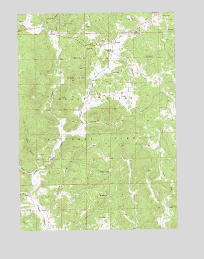
Fourmile, SD USGS Topographic Map
Click on map above to begin viewing in our Map Viewer.

This topographic map contains these locations and features:
Feature Name Type Latitude Longitude GNIS ID View Map
Bebington Group MineMineN43.7450°W103.6477°1265049View Map
Carroll Creek SpringSpringN43.6372°W103.6324°1261411View Map
Castle RockPillarN43.7244°W103.7013°1261418View Map
Comanche Park CampgroundLocaleN43.7350°W103.7119°1263041View Map
Dubuque ClaimMineN43.7430°W103.6958°1265050View Map
FourmilePopulated PlaceN43.7328°W103.6755°1261691View Map
Fourmile CreekStreamN43.6791°W103.7146°1261692View Map
Fourmile SchoolSchoolN43.7286°W103.6760°1261693View Map
Griffis CanyonValleyN43.6641°W103.7297°1261750View Map
Griffis WellWellN43.6689°W103.7346°1261751View Map
Harrymill Picnic AreaLocaleN43.7344°W103.7058°1263040View Map
Hay CreekStreamN43.6961°W103.6944°1261789View Map
Helen Beryl MineMineN43.7128°W103.6974°1261799View Map
Keystone Lode MineMineN43.7436°W103.7033°1265052View Map
Layton CanyonValleyN43.6578°W103.7410°1261941View Map
Lightning CreekStreamN43.6791°W103.7146°1261950View Map
Long DrawValleyN43.6369°W103.7296°1261986View Map
McClure DamDamN43.6322°W103.6824°1262036View Map
New York MineMineN43.7025°W103.6866°1262122View Map
Nine Mile Ranch (historical)LocaleN43.6875°W103.7041°1264620View Map
Ninemile DrawValleyN43.6859°W103.6970°1262128View Map
Pleasant Valley Station (historical)LocaleN43.6944°W103.6983°1264618View Map
Rafferty Ranch (historical)LocaleN43.6491°W103.6477°1264158View Map
Rainbow Number Four MineMineN43.7297°W103.6963°1262258View Map
Red Spar MineMineN43.6941°W103.7255°1262282View Map
Rocky Ridge MineMineN43.7247°W103.6421°1262325View Map
Royal Flush Claim MineMineN43.7416°W103.6938°1265051View Map
S and G CanyonValleyN43.6457°W103.7442°1262345View Map
Sevenmile SchoolSchoolN43.6941°W103.7019°1262387View Map
Spar SpringSpringN43.7397°W103.6313°1262474View Map
Spring on the Right (historical)LocaleN43.6255°W103.7041°1264615View Map
Sutherland Ranch (historical)LocaleN43.6703°W103.6408°1264157View Map
Tin Mountain MineMineN43.7469°W103.7210°1262593View Map
Tiptop MineMineN43.7155°W103.6699°1262594View Map
Twelve Mile Ranch (historical)LocaleN43.6550°W103.7413°1264621View Map
Twin SistersSummitN43.7138°W103.7060°1262616View Map
Ventling ReservoirReservoirN43.6584°W103.6788°1262634View Map
Ward ReservoirReservoirN43.6447°W103.6793°1262659View Map
Warren Draw MineMineN43.7439°W103.7149°1262661View Map
Warren GulchValleyN43.7378°W103.7204°1262662View Map
White Spar MineMineN43.7480°W103.6280°1262701View Map
Woods Ranch (historical)LocaleN43.7028°W103.6635°1264156View Map

Note: Coordinates in the location and feature list above are referenced to NAD83 datum.


Copyright (C) 2008-2024 Ryan Niemi / Sunset Dynamics ... All Rights Reserved