TopoQuest Logo
Do you find TopoQuest useful?
Help keep TopoQuest running and adding new maps/features by donating!
Bitcoin:  19c7KJd3qBynnjoSw5npx9KScwjBe4ifkT
Litecoin:  LXs6TkuXGGXo1vDsWCkWVdjQX94eUKd6ui
Home View Maps Find Maps Find Places Resources & Links


Frakes, Kentucky Topographic Map

USGS Map Title: Frakes, KY
USGS Map MRC: 36083F8
DRG (GeoTIFF) Download: o36083f8.tif


Neighboring USGS Topographic Map Quads:


  Rockholds, KY  
36084G1
 

  Barbourville, KY  
36083G8
 

  Artemus, KY  
36083G7
 

  Saxton, KY  
36084F1
 

  Frakes, KY  
36083F8
 

  Kayjay, KY  
36083F7
 

  Jellico East, TN  
36084E1
 

  Eagan, TN  
36083E8
 

  Fork Ridge, TN  
36083E7


Map MRC Location:

N37°
W84°
N37°
W83°
H8 H7 H6 H5 H4 H3 H2 H1
G8 G7 G6 G5 G4 G3 G2 G1
F8 F7 F6 F5 F4 F3 F2 F1
E8 E7 E6 E5 E4 E3 E2 E1
D8 D7 D6 D5 D4 D3 D2 D1
C8 C7 C6 C5 C4 C3 C2 C1
B8 B7 B6 B5 B4 B3 B2 B1
A8 A7 A6 A5 A4 A3 A2 A1
N36°
W84°
N36°
W83°

Frakes, KY USGS 1:24K Topographic Map Preview:
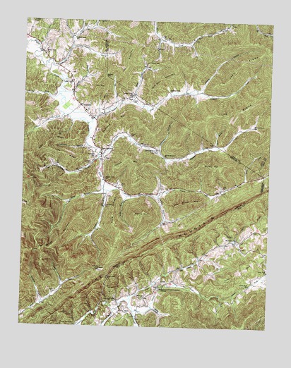
Frakes, KY USGS Topographic Map
Click on map above to begin viewing in our Map Viewer.

This topographic map contains these locations and features:
Feature Name Type Latitude Longitude GNIS ID View Map
Anchor Post Office (historical)Post OfficeN36.7477°W83.8819°2543211View Map
Anchor Railroad Station (historical)LocaleN36.7478°W83.8822°2543212View Map
Bear Wallow MountainSummitN36.6576°W83.9905°486578View Map
Beech Bottom ChurchChurchN36.6979°W83.9319°486687View Map
Beech Bottom SchoolSchoolN36.6954°W83.9288°486688View Map
Bennett BranchStreamN36.6995°W83.9671°486850View Map
Bennett CemeteryCemeteryN36.7037°W83.9460°486854View Map
Birdseye Post Office (historical)Post OfficeN36.7434°W83.9323°2554670View Map
Black Top ChurchChurchN36.6376°W83.9371°487392View Map
Bob Bray MountainSummitN36.7220°W83.9269°487599View Map
Browns CemeteryCemeteryN36.7006°W83.9030°488029View Map
Brushy MountainSummitN36.6923°W83.9033°488147View Map
Buffalo CreekStreamN36.7326°W83.9858°488310View Map
Buffalo Creek SchoolSchoolN36.7434°W83.9747°488322View Map
Buffalo GapGapN36.7276°W83.9588°488323View Map
CarpenterPopulated PlaceN36.7159°W83.9713°507657View Map
Carpenter HollowValleyN36.6353°W83.9892°488963View Map
Charlie BranchStreamN36.6417°W83.9791°489369View Map
Coalstone BranchStreamN36.6945°W83.9619°489739View Map
Coalstone SchoolSchoolN36.6951°W83.9633°489741View Map
Cooks Store (historical)BuildingN36.6411°W83.9655°2710181View Map
Cox HollowValleyN36.7168°W83.9530°490224View Map
Croley CemeteryCemeteryN36.7184°W83.9446°490365View Map
Davis BranchStreamN36.7176°W83.9449°490631View Map
Dink RidgeRidgeN36.7012°W83.9869°490898View Map
Doolin BranchStreamN36.6790°W83.9471°491005View Map
East Ridge BranchStreamN36.7409°W83.9160°491502View Map
Evans BranchStreamN36.6993°W83.9013°491828View Map
Flag RidgeRidgeN36.7140°W83.8949°492162View Map
Fork RidgeRidgeN36.7337°W83.8902°492341View Map
FrakesPopulated PlaceN36.6429°W83.9277°508032View Map
Frakes Volunteer Fire DepartmentBuildingN36.6423°W83.9275°2636494View Map
Fuson ChurchChurchN36.6367°W83.9530°492633View Map
Gatliff Lookout TowerTowerN36.6823°W83.9916°517161View Map
GoinsPopulated PlaceN36.7001°W83.9394°508106View Map
Goins CemeteryCemeteryN36.6973°W83.9316°492940View Map
Goldens CreekStreamN36.7087°W83.9669°492944View Map
Goldens Creek SchoolSchoolN36.7218°W83.9269°492945View Map
Goldens MountainSummitN36.7115°W83.9463°492946View Map
Greasy GapGapN36.6873°W83.8776°2711281View Map
HamblimPopulated PlaceN36.6555°W83.8770°2710804View Map
Happy HollowValleyN36.6328°W83.9324°493699View Map
Harpes CreekStreamN36.6959°W83.9616°493788View Map
Harpes Creek SchoolSchoolN36.7079°W83.8830°493789View Map
Henderson CemeteryCemeteryN36.6626°W83.8924°494027View Map
Henderson GrovePopulated PlaceN36.6606°W83.8901°2554942View Map
Henderson Grove ChurchChurchN36.6615°W83.8899°494039View Map
Henderson Settlement SchoolSchoolN36.6409°W83.9291°494041View Map
Henry Bowlin GapGapN36.6456°W83.9563°494054View Map
Indian GapGapN36.7337°W83.9369°494946View Map
Joe RidgeRidgeN36.6956°W83.9791°495301View Map
Jones CemeteryCemeteryN36.6829°W83.8985°495464View Map
Laurel Fork SchoolSchoolN36.6431°W83.8841°496049View Map
Lawson CemeteryCemeteryN36.6398°W83.9824°496086View Map
Lawson CemeteryCemeteryN36.6834°W83.9505°496087View Map
Lawson MountainSummitN36.6884°W83.9433°496092View Map
Lay MountainSummitN36.7398°W83.9455°496098View Map
Lick ForkStreamN36.7120°W83.9794°496492View Map
Limestone BranchStreamN36.6784°W83.9313°496543View Map
Little Round MountainSummitN36.6762°W83.9185°496852View Map
Locust Grove ChurchChurchN36.7184°W83.9444°496949View Map
Locust RidgeRidgeN36.7184°W83.9596°496965View Map
Long ForkStreamN36.6856°W83.8874°497099View Map
Lower Laurel Fork ChurchChurchN36.6259°W83.9716°497293View Map
Mays CemeteryCemeteryN36.7437°W83.9294°497743View Map
McKiddy CemeteryCemeteryN36.6926°W83.9655°497902View Map
Middlepoint Post Office (historical)Post OfficeN36.7425°W83.9148°2554669View Map
Miller BranchStreamN36.7481°W83.9652°498318View Map
Mossy Gap ChurchChurchN36.7370°W83.9902°498678View Map
Mud Creek GapGapN36.6498°W83.9619°498986View Map
New Vine ChurchChurchN36.6487°W83.8752°499407View Map
Partin CemeteryCemeteryN36.6667°W83.8752°500228View Map
Partin CemeteryCemeteryN36.6681°W83.9266°500229View Map
Partins Mill (historical)LocaleN36.6681°W83.8843°2554941View Map
Peace Memorial ChurchChurchN36.6970°W83.9599°500316View Map
PearlPopulated PlaceN36.6315°W83.9466°508787View Map
Pine CreekStreamN36.6370°W83.9444°500673View Map
Piney SpurRidgeN36.6554°W83.8777°500736View Map
Poll TopSummitN36.7240°W83.9605°501007View Map
Poplar Creek ChurchChurchN36.6859°W83.9580°501098View Map
Poplar Creek SchoolSchoolN36.7256°W83.9760°501099View Map
Powers BranchStreamN36.7398°W83.9763°501252View Map
Pruden-Fonde DivisionCivilN36.6306°W83.8893°1937213View Map
Puncheon BranchStreamN36.6962°W83.9308°501436View Map
RainPopulated PlaceN36.7206°W83.9449°508894View Map
Reynolds Store (historical)BuildingN36.7129°W83.9677°2710229View Map
Rocky ForkStreamN36.7201°W83.9822°515071View Map
Roses Store (historical)BuildingN36.7210°W83.9747°2710230View Map
Round MountainSummitN36.6712°W83.9402°502408View Map
Runyon BranchStreamN36.7226°W83.9130°502471View Map
Sandy BranchStreamN36.7212°W83.9797°502971View Map
Seng BranchStreamN36.6818°W83.9591°503171View Map
SilerPopulated PlaceN36.6945°W83.9588°503497View Map
Siler CemeteryCemeteryN36.6917°W83.9833°503498View Map
The Big OakParkN36.6681°W83.9269°2710252View Map
Tiny BranchStreamN36.6320°W83.9524°505299View Map
Trace BranchStreamN36.6809°W83.9574°505405View Map
Trace Branch SchoolSchoolN36.6748°W83.9585°505418View Map
Trace RidgeRidgeN36.6718°W83.9533°505451View Map
Wells CemeteryCemeteryN36.7479°W83.9702°506373View Map
Wheeler CreekStreamN36.6317°W83.9421°506538View Map

Note: Coordinates in the location and feature list above are referenced to NAD83 datum.


Copyright (C) 2008-2024 Ryan Niemi / Sunset Dynamics ... All Rights Reserved