TopoQuest Logo
Do you find TopoQuest useful?
Help keep TopoQuest running and adding new maps/features by donating!
Bitcoin:  19c7KJd3qBynnjoSw5npx9KScwjBe4ifkT
Litecoin:  LXs6TkuXGGXo1vDsWCkWVdjQX94eUKd6ui
Home View Maps Find Maps Find Places Resources & Links


Frankfort, Illinois Topographic Map

USGS Map Title: Frankfort, IL
USGS Map MRC: 41087D7
DRG (GeoTIFF) Download: o41087d7.tif


Neighboring USGS Topographic Map Quads:


  Mokena, IL  
41087E8
 

  Tinley Park, IL  
41087E7
 

  Harvey, IL  
41087E6
 

  Manhattan, IL  
41087D8
 

  Frankfort, IL  
41087D7
 

  Steger, IL  
41087D6
 

  Wilton Center, IL  
41087C8
 

  Peotone, IL  
41087C7
 

  Beecher West, IL  
41087C6


Map MRC Location:

N42°
W88°
N42°
W87°
H8 H7 H6 H5 H4 H3 H2 H1
G8 G7 G6 G5 G4 G3 G2 G1
F8 F7 F6 F5 F4 F3 F2 F1
E8 E7 E6 E5 E4 E3 E2 E1
D8 D7 D6 D5 D4 D3 D2 D1
C8 C7 C6 C5 C4 C3 C2 C1
B8 B7 B6 B5 B4 B3 B2 B1
A8 A7 A6 A5 A4 A3 A2 A1
N41°
W88°
N41°
W87°

Frankfort, IL USGS 1:24K Topographic Map Preview:
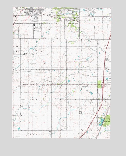
Frankfort, IL USGS Topographic Map
Click on map above to begin viewing in our Map Viewer.

This topographic map contains these locations and features:
Feature Name Type Latitude Longitude GNIS ID View Map
Airport Industrial ParkLocaleN41.4756°W87.8433°2355472View Map
Breidert Green ParkParkN41.4986°W87.8498°1822295View Map
Brookside ParkParkN41.4995°W87.8662°422291View Map
Camp ManitoquaLocaleN41.4903°W87.8131°1822293View Map
Country HillsPopulated PlaceN41.4017°W87.7878°2355779View Map
Country OaksPopulated PlaceN41.4225°W87.7539°2355776View Map
Esch School (historical)SchoolN41.4561°W87.8062°1736605View Map
Fehland School (historical)SchoolN41.4273°W87.7667°1736608View Map
FrankfortPopulated PlaceN41.4959°W87.8487°423589View Map
Frankfort AirportAirportN41.4775°W87.8390°427292View Map
Frankfort Fire Protection District Station 1BuildingN41.4980°W87.8585°2682036View Map
Frankfort Junior High SchoolSchoolN41.4873°W87.8084°422289View Map
Frankfort SchoolSchoolN41.4964°W87.8512°422288View Map
Frankfort United Methodist ChurchChurchN41.4950°W87.8459°1822294View Map
Gorman FarmPopulated PlaceN41.4094°W87.7744°2355775View Map
Green Garden Country ClubLocaleN41.4214°W87.8403°422293View Map
Green Garden Elementary SchoolSchoolN41.4267°W87.8437°1822290View Map
Harms School (historical)SchoolN41.4261°W87.8059°1736628View Map
Hasenjager School (historical)SchoolN41.4550°W87.8448°1736629View Map
Hickory Creek Elementary SchoolSchoolN41.4881°W87.8078°422290View Map
Interchange 335CrossingN41.4270°W87.7595°1822349View Map
Main ParkParkN41.4959°W87.8595°422287View Map
Meadow Creek AirportAirportN41.4328°W87.7817°427560View Map
Monee Fire Protection District Station 2BuildingN41.4226°W87.7861°2682139View Map
Monee ReservoirReservoirN41.3913°W87.7612°413721View Map
Monee Reservoir DamDamN41.3884°W87.7612°1691664View Map
Pleasant Hill CemeteryCemeteryN41.4991°W87.8660°415825View Map
Prestwick Country ClubLocaleN41.4959°W87.8028°422292View Map
Raccoon GroveWoodsN41.3950°W87.7550°416336View Map
Raccoon Grove Forest PreserveParkN41.3931°W87.7559°1822288View Map
Rahm School (historical)SchoolN41.4850°W87.8092°1736721View Map
Ridgeland Lakes EstatesPopulated PlaceN41.4192°W87.7714°2355774View Map
Rose Hill CemeteryCemeteryN41.4551°W87.8566°416944View Map
Saint Anthonys ChurchChurchN41.4878°W87.8064°1822292View Map
Saint John's United Church of Christ CemeteryCemeteryN41.3809°W87.8251°1952363View Map
Saint Johns ChurchChurchN41.3814°W87.8253°417404View Map
Saint Peter's CemeteryCemeteryN41.4545°W87.8062°417750View Map
Saint Peters United Church of ChristChurchN41.4956°W87.8492°422294View Map
Sauk Trail DamDamN41.4884°W87.7967°1692654View Map
Sauk Trail Forest PreserveParkN41.4853°W87.8000°1822289View Map
Schafer School (historical)SchoolN41.3973°W87.8445°1736736View Map
Schannen School (historical)SchoolN41.3975°W87.7664°1736737View Map
Schlem CemeteryCemeteryN41.4066°W87.7647°418088View Map
Sinter Metals Industrial ParkLocaleN41.4823°W87.7581°2036246View Map
Stassen School (historical)SchoolN41.3970°W87.8062°1736749View Map
Timber Ridge Mobile Home ParkPopulated PlaceN41.4956°W87.7756°2036247View Map
Township of Green GardenCivilN41.4263°W87.8453°429079View Map
Twining CemeteryCemeteryN41.4400°W87.8716°419989View Map
Union CemeteryCemeteryN41.4268°W87.8064°420025View Map
Village of FrankfortCivilN41.4912°W87.8395°2398915View Map
Village of MoneeCivilN41.4173°W87.7504°2399381View Map
Washington Royal School (historical)SchoolN41.4928°W87.7520°1737296View Map
Wix AirportAirportN41.3983°W87.8166°427559View Map

Note: Coordinates in the location and feature list above are referenced to NAD83 datum.


Copyright (C) 2008-2024 Ryan Niemi / Sunset Dynamics ... All Rights Reserved