TopoQuest Logo
Do you find TopoQuest useful?
Help keep TopoQuest running and adding new maps/features by donating!
Bitcoin:  19c7KJd3qBynnjoSw5npx9KScwjBe4ifkT
Litecoin:  LXs6TkuXGGXo1vDsWCkWVdjQX94eUKd6ui
Home View Maps Find Maps Find Places Resources & Links


Franktown, Virginia Topographic Map

USGS Map Title: Franktown, VA
USGS Map MRC: 37075D8
DRG (GeoTIFF) Download: o37075d8.tif


Neighboring USGS Topographic Map Quads:


  West of Jamesville, VA  
37076E1
 

  Jamesville, VA  
37075E8
 

  Exmore, VA  
37075E7
 

  West of Franktown, VA  
37076D1
 

  Franktown, VA  
37075D8
 

  Nassawadox, VA  
37075D7
 

  Cape Charles, VA  
37076C1
 

  Cheriton, VA  
37075C8
 

  Cobb Island, VA  
37075C7


Map MRC Location:

N38°
W76°
N38°
W75°
H8 H7 H6 H5 H4 H3 H2 H1
G8 G7 G6 G5 G4 G3 G2 G1
F8 F7 F6 F5 F4 F3 F2 F1
E8 E7 E6 E5 E4 E3 E2 E1
D8 D7 D6 D5 D4 D3 D2 D1
C8 C7 C6 C5 C4 C3 C2 C1
B8 B7 B6 B5 B4 B3 B2 B1
A8 A7 A6 A5 A4 A3 A2 A1
N37°
W76°
N37°
W75°

Franktown, VA USGS 1:24K Topographic Map Preview:
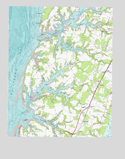
Franktown, VA USGS Topographic Map
Click on map above to begin viewing in our Map Viewer.

This topographic map contains these locations and features:
Feature Name Type Latitude Longitude GNIS ID View Map
Antioch ChurchChurchN37.4290°W75.8927°1462506View Map
Barlow CreekStreamN37.3857°W75.9752°1495232View Map
BayfordPopulated PlaceN37.4779°W75.9327°1494825View Map
Bayleys Neck FarmPopulated PlaceN37.4654°W75.9149°1739162View Map
Bethel ChurchChurchN37.4776°W75.8844°1463183View Map
BirdsnestPopulated PlaceN37.4390°W75.8810°1463454View Map
Birdsnest Post OfficePost OfficeN37.4262°W75.8902°1739164View Map
BridgetownPopulated PlaceN37.4457°W75.9263°1494849View Map
Campbell FieldAirportN37.4605°W75.8791°1498847View Map
Cardinal EstatesPopulated PlaceN37.4418°W75.8955°1739181View Map
Chatham Vineyards and WineryBuildingN37.4566°W75.9306°2518589View Map
Church CreekStreamN37.4737°W75.9388°1464910View Map
Church Creek PointPopulated PlaceN37.4682°W75.9310°1739190View Map
Church NeckCapeN37.4429°W75.9597°1464911View Map
Church PointCapeN37.4726°W75.9430°1464913View Map
Deerfield EstatesPopulated PlaceN37.3946°W75.9519°1739194View Map
Downings BeachLocaleN37.4949°W75.9594°1465928View Map
Elliotts NeckCapeN37.4715°W75.9144°1466248View Map
FranktownPopulated PlaceN37.4787°W75.8788°1494945View Map
Franktown Methodist ChurchChurchN37.4762°W75.8819°1739204View Map
Franktown Post OfficePost OfficeN37.4767°W75.8774°1739205View Map
Great NeckCapeN37.4165°W75.9808°1467444View Map
Gull PointCapeN37.4815°W75.9272°1739207View Map
Harbour PointPopulated PlaceN37.4168°W75.9544°1739208View Map
Hideaway CovePopulated PlaceN37.4846°W75.9427°1739210View Map
Holly Grove CoveBayN37.4962°W75.8927°1468160View Map
Holly Grove VineyardsBuildingN37.4939°W75.8947°2518590View Map
Honeymoon IslandIslandN37.3904°W75.9805°1468212View Map
Horse IslandIslandN37.4707°W75.9574°1468263View Map
Hungars BeachBeachN37.3812°W75.9860°1468380View Map
Hungars ChurchChurchN37.4471°W75.9233°1468381View Map
Hungars CreekStreamN37.4035°W75.9766°1502796View Map
Hungars PointPopulated PlaceN37.4262°W75.9674°1739214View Map
Hungars Wharf (historical)LocaleN37.3854°W75.9835°1739215View Map
Jacobus CreekStreamN37.4224°W75.9535°1468621View Map
Jacobus PointCapeN37.4199°W75.9385°1468622View Map
Johnsons ChurchChurchN37.4279°W75.9149°1468807View Map
JohnsontownPopulated PlaceN37.4254°W75.9141°1495007View Map
Long PointCapeN37.4779°W75.9435°1469826View Map
MachipongoPopulated PlaceN37.4060°W75.9016°1495048View Map
Machipongo Elementary SchoolSchoolN37.4037°W75.9102°1739222View Map
Machipongo International AirportAirportN37.3861°W75.8910°2675647View Map
Machipongo Post OfficePost OfficeN37.4028°W75.9030°1739223View Map
Martins SidingPopulated PlaceN37.3901°W75.9097°1470139View Map
Masden GutGutN37.4143°W75.9583°1470149View Map
Mattawoman CreekStreamN37.3935°W75.9672°1470193View Map
Mears DamDamN37.3785°W75.9430°1490472View Map
Miller DamDamN37.3935°W75.9413°1490474View Map
Miller PondReservoirN37.3965°W75.9385°1490475View Map
Mount Zion ChurchChurchN37.4287°W75.8919°1471132View Map
Nassawadox CreekStreamN37.4715°W75.9608°1471329View Map
Nassawadox PointCapeN37.4743°W75.9602°1471330View Map
Northampton County Department of Emergency Medical ServicesBuildingN37.3990°W75.9120°2331837View Map
Northampton Middle SchoolSchoolN37.4037°W75.9092°1739236View Map
Oldtown Neck Fort (historical)MilitaryN37.3906°W75.9667°1739241View Map
Paraplane CoveBayN37.4307°W75.9574°1472052View Map
Peaceful Beach EstatesPopulated PlaceN37.4935°W75.9566°1739244View Map
ReedtownPopulated PlaceN37.3799°W75.9149°1477672View Map
ShadysidePopulated PlaceN37.3979°W75.9122°1477733View Map
Shooting PointCapeN37.4687°W75.9599°1474546View Map
Shorters Chapel African Methodist Episcopal ChurchChurchN37.4446°W75.9277°1739252View Map
Silver BeachPopulated PlaceN37.4854°W75.9605°1495127View Map
Solitude TrailsPopulated PlaceN37.3932°W75.9444°1739254View Map
South IslandIslandN37.4693°W75.9627°1474873View Map
Sparrow PointCapeN37.4179°W75.9658°1474931View Map
Taylor WharfLocaleN37.3960°W75.9655°1475512View Map
The SaltworksCapeN37.4879°W75.9299°1478014View Map
The Saltworks (historical)LocaleN37.4871°W75.9330°1739256View Map
The T E C H Center SchoolSchoolN37.4038°W75.9105°2464928View Map
TrehernevillePopulated PlaceN37.4271°W75.8902°1495152View Map
Vaucluse PointCapeN37.4135°W75.9744°1476156View Map
Vaucluse ShoresPopulated PlaceN37.4243°W75.9788°1739260View Map
Warehouse CreekStreamN37.4837°W75.9224°1476331View Map
Waterford PointCapeN37.4254°W75.9519°1476373View Map
Weirwood FairgroundsLocaleN37.4624°W75.8888°1476437View Map
Wellington NeckCapeN37.4915°W75.8899°1476442View Map
Westerhouse CreekStreamN37.4529°W75.9694°1476515View Map
Westerhouse WoodsPopulated PlaceN37.4429°W75.9702°1739264View Map
Wilson NeckCapeN37.4046°W75.9541°1476826View Map

Note: Coordinates in the location and feature list above are referenced to NAD83 datum.


Copyright (C) 2008-2024 Ryan Niemi / Sunset Dynamics ... All Rights Reserved