TopoQuest Logo
Do you find TopoQuest useful?
Help keep TopoQuest running and adding new maps/features by donating!
Bitcoin:  19c7KJd3qBynnjoSw5npx9KScwjBe4ifkT
Litecoin:  LXs6TkuXGGXo1vDsWCkWVdjQX94eUKd6ui
Home View Maps Find Maps Find Places Resources & Links


Exmore, Virginia Topographic Map

USGS Map Title: Exmore, VA
USGS Map MRC: 37075E7
DRG (GeoTIFF) Download: o37075e7.tif


Neighboring USGS Topographic Map Quads:


  Nandua Creek, VA  
37075F8
 

  Pungoteague, VA  
37075F7
 

  Accomac, VA  
37075F6
 

  Jamesville, VA  
37075E8
 

  Exmore, VA  
37075E7


  Franktown, VA  
37075D8
 

  Nassawadox, VA  
37075D7
 

  Quinby Inlet, VA  
37075D6


Map MRC Location:

N38°
W76°
N38°
W75°
H8 H7 H6 H5 H4 H3 H2 H1
G8 G7 G6 G5 G4 G3 G2 G1
F8 F7 F6 F5 F4 F3 F2 F1
E8 E7 E6 E5 E4 E3 E2 E1
D8 D7 D6 D5 D4 D3 D2 D1
C8 C7 C6 C5 C4 C3 C2 C1
B8 B7 B6 B5 B4 B3 B2 B1
A8 A7 A6 A5 A4 A3 A2 A1
N37°
W76°
N37°
W75°

Exmore, VA USGS 1:24K Topographic Map Preview:
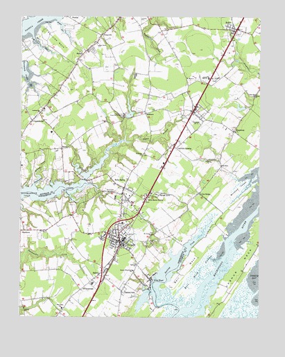
Exmore, VA USGS Topographic Map
Click on map above to begin viewing in our Map Viewer.

This topographic map contains these locations and features:
Feature Name Type Latitude Longitude GNIS ID View Map
Ames - Hyslop Family CemeteryCemeteryN37.5919°W75.8144°2780406View Map
Ames GraveCemeteryN37.5986°W75.7750°2780402View Map
Ames Plot CemeteryCemeteryN37.5987°W75.7785°2780401View Map
Ames RidgeRidgeN37.5987°W75.7810°1462444View Map
Anderson Place CemeteryCemeteryN37.5834°W75.8539°2780407View Map
Ayres PlotCemeteryN37.5606°W75.7730°2780442View Map
Bacon HillPopulated PlaceN37.5285°W75.8177°1739160View Map
Bell NeckCapeN37.5199°W75.7888°1463026View Map
Bell Neck SwampSwampN37.5199°W75.7808°1463027View Map
Belle HavenPopulated PlaceN37.5543°W75.8205°1463039View Map
Belle Haven CemeteryCemeteryN37.5528°W75.8286°1463040View Map
Belle Haven Post OfficePost OfficeN37.5534°W75.8207°1779635View Map
Belle Haven StationLocaleN37.5490°W75.8094°1463041View Map
Boggs GutGutN37.6201°W75.8538°1463632View Map
BostonPopulated PlaceN37.6093°W75.8427°1494187View Map
Boston Census Designated PlaceCensusN37.6039°W75.8437°2584810View Map
Broadwater AcademySchoolN37.5286°W75.8477°1739165View Map
Bull PlotCemeteryN37.5694°W75.7736°2780443View Map
Cats BridgePopulated PlaceN37.5518°W75.7819°1464551View Map
Cats Bridge Census Designated PlaceCensusN37.5491°W75.7797°2584827View Map
Central Middle SchoolSchoolN37.5996°W75.7770°1464693View Map
Coal KilnLocaleN37.5632°W75.7702°1465016View Map
Coal Kiln CemeteryCemeteryN37.5642°W75.7680°2780441View Map
Coal Kiln CrossingPopulated PlaceN37.5710°W75.7944°1494199View Map
Community Fire CompanyBuildingN37.5297°W75.8233°2086097View Map
CraddockvillePopulated PlaceN37.5818°W75.8688°1465389View Map
Craddockville ChurchChurchN37.5851°W75.8647°1465390View Map
Craddockville Post OfficePost OfficeN37.5810°W75.8698°1779642View Map
Custis DamDamN37.6185°W75.8530°1488979View Map
Custis PondReservoirN37.6185°W75.8530°1488980View Map
District 8CivilN37.5778°W75.7569°1927289View Map
Duer DamDamN37.5835°W75.8313°1488973View Map
Duer PondReservoirN37.5835°W75.8313°1488974View Map
Ebenezer ChurchChurchN37.5357°W75.8613°1466147View Map
Epworth ChurchChurchN37.5218°W75.8141°1466339View Map
Epworth United Methodist Church CemeteryCemeteryN37.5222°W75.8143°2780435View Map
ExmorePopulated PlaceN37.5318°W75.8230°1466377View Map
Exmore Baptist ChurchChurchN37.5329°W75.8238°1739198View Map
Exmore Police DepartmentBuildingN37.5309°W75.8224°2086106View Map
Exmore Post OfficePost OfficeN37.5311°W75.8219°1739199View Map
Exmore Wesleyan SchoolSchoolN37.5326°W75.8266°1739200View Map
Exmore-Willis Wharf Elementary SchoolSchoolN37.5193°W75.8158°1466378View Map
Fairview NeckCapeN37.6143°W75.8558°1466421View Map
Fisher PointCapeN37.5499°W75.8702°1466604View Map
HadlockPopulated PlaceN37.5176°W75.8335°1467632View Map
Hare Valley Elementary SchoolSchoolN37.5037°W75.8527°1467747View Map
Highland HeightsPopulated PlaceN37.5493°W75.8335°1739211View Map
Holy Trinity ChurchChurchN37.6129°W75.8347°1468190View Map
KellerPopulated PlaceN37.6193°W75.7638°1468935View Map
Keller Post OfficePost OfficeN37.6194°W75.7634°1779652View Map
MappsburgPopulated PlaceN37.5776°W75.7635°1470085View Map
Mappsburg Census Designated PlaceCensusN37.5760°W75.7592°2584874View Map
McLean GutGutN37.6121°W75.8649°1470273View Map
MiddlesexPopulated PlaceN37.5846°W75.8097°1477537View Map
MiddlesexPopulated PlaceN37.5793°W75.8369°1779660View Map
Miles WharfLocaleN37.5507°W75.8563°1739226View Map
Miles WharfLocaleN37.5499°W75.8588°1478010View Map
Moreland SwampSwampN37.5543°W75.7608°1470731View Map
Mount Calvary ChurchChurchN37.5349°W75.8066°1470829View Map
Mount ZionPopulated PlaceN37.5660°W75.7830°1779661View Map
Mount Zion ChurchChurchN37.5657°W75.7772°1471136View Map
NanduaPopulated PlaceN37.6243°W75.8499°1494250View Map
New Zion Baptist Church CemeteryCemeteryN37.5655°W75.7779°2780446View Map
Nock CemeteryCemeteryN37.5545°W75.7823°2780438View Map
Northampton Shopping CenterLocaleN37.5224°W75.8330°1739237View Map
Oakland ParkPopulated PlaceN37.5107°W75.8213°1494253View Map
Occohannock Elementary SchoolSchoolN37.5212°W75.8156°2465065View Map
Old Bell CemeteryCemeteryN37.5132°W75.7999°2780437View Map
PainterPopulated PlaceN37.5854°W75.7849°1472020View Map
Painter FieldAirportN37.5687°W75.7919°2787192View Map
Painter Post OfficePost OfficeN37.5862°W75.7857°1779669View Map
Painter Volunteer Fire DepartmentBuildingN37.5859°W75.7862°2075664View Map
Parting CreekStreamN37.5037°W75.7916°1472087View Map
PennyvillePopulated PlaceN37.6176°W75.8327°1494255View Map
Phillips Place CemeteryCemeteryN37.5323°W75.7980°1739246View Map
Powell PlotCemeteryN37.5750°W75.7676°2780444View Map
Red HillPopulated PlaceN37.5926°W75.7519°1477667View Map
Rue WharfLocaleN37.5560°W75.8388°1478011View Map
Saint Josephs ChurchChurchN37.5676°W75.8110°1473791View Map
Savage TownPopulated PlaceN37.5521°W75.8013°1474069View Map
Savage Town Census Designated PlaceCensusN37.5501°W75.7983°2584914View Map
Sheilds WharfLocaleN37.5549°W75.8497°1478015View Map
ShieldsPopulated PlaceN37.5701°W75.8535°1477747View Map
Shields CoveBayN37.5571°W75.8658°1474492View Map
Shields CreekStreamN37.5537°W75.8677°1474493View Map
Shiloh ChurchChurchN37.6112°W75.8397°1474514View Map
Sneads ChurchChurchN37.5921°W75.7527°1474806View Map
Sturgis - Painter CemeteryCemeteryN37.5639°W75.7818°2780447View Map
Taylor BranchStreamN37.5735°W75.8208°1475498View Map
TB CrossroadsPopulated PlaceN37.5115°W75.8433°1475418View Map
The Salmon Farm AirportAirportN37.6134°W75.8033°2717081View Map
Town of Belle HavenCivilN37.5556°W75.8259°2390720View Map
Town of ExmoreCivilN37.5295°W75.8283°2390172View Map
Town of KellerCivilN37.6212°W75.7642°2391250View Map
Town of PainterCivilN37.5852°W75.7837°2391349View Map
Turner PlotCemeteryN37.5762°W75.7742°2780445View Map
Upshur NeckCapeN37.5212°W75.7599°1476126View Map
Virginia Marine Police - Eastern Shore OfficeBuildingN37.5466°W75.8140°2767139View Map
Virginia Tech - Virginia Cooperative ExtensionSchoolN37.5036°W75.8530°2465426View Map
Virginia Truck and Experimental Station DamDamN37.5835°W75.8213°1488975View Map
Virginia Truck and Experimental Station ReservoirReservoirN37.5835°W75.8213°1488976View Map
Virginia Truck Experimental StationLocaleN37.5846°W75.8208°1476203View Map
Wardtown Post OfficePost OfficeN37.5357°W75.8744°1739262View Map
Wescott CoveBayN37.5501°W75.8485°1476452View Map
Willis WharfPopulated PlaceN37.5157°W75.8066°1494294View Map
Willis Wharf Post OfficePost OfficeN37.5154°W75.8061°1739265View Map
WPHG-FM (Exmore)TowerN37.5543°W75.8269°1502635View Map
Young PointCapeN37.5529°W75.8530°1474366View Map

Note: Coordinates in the location and feature list above are referenced to NAD83 datum.


Copyright (C) 2008-2024 Ryan Niemi / Sunset Dynamics ... All Rights Reserved