TopoQuest Logo
Do you find TopoQuest useful?
Help keep TopoQuest running and adding new maps/features by donating!
Bitcoin:  19c7KJd3qBynnjoSw5npx9KScwjBe4ifkT
Litecoin:  LXs6TkuXGGXo1vDsWCkWVdjQX94eUKd6ui
Home View Maps Find Maps Find Places Resources & Links


Fredericksburg, Pennsylvania Topographic Map

USGS Map Title: Fredericksburg, PA
USGS Map MRC: 40076D4
DRG (GeoTIFF) Download: o40076d4.tif


Neighboring USGS Topographic Map Quads:


  Tower City, PA  
40076E5
 

  Pine Grove, PA  
40076E4
 

  Swatara Hill, PA  
40076E3
 

  Indiantown Gap, PA  
40076D5
 

  Fredericksburg, PA  
40076D4
 

  Bethel, PA  
40076D3
 

  Palmyra, PA  
40076C5
 

  Lebanon, PA  
40076C4
 

  Richland, PA  
40076C3


Map MRC Location:

N41°
W77°
N41°
W76°
H8 H7 H6 H5 H4 H3 H2 H1
G8 G7 G6 G5 G4 G3 G2 G1
F8 F7 F6 F5 F4 F3 F2 F1
E8 E7 E6 E5 E4 E3 E2 E1
D8 D7 D6 D5 D4 D3 D2 D1
C8 C7 C6 C5 C4 C3 C2 C1
B8 B7 B6 B5 B4 B3 B2 B1
A8 A7 A6 A5 A4 A3 A2 A1
N40°
W77°
N40°
W76°

Fredericksburg, PA USGS 1:24K Topographic Map Preview:
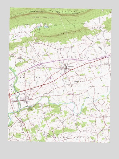
Fredericksburg, PA USGS Topographic Map
Click on map above to begin viewing in our Map Viewer.

This topographic map contains these locations and features:
Feature Name Type Latitude Longitude GNIS ID View Map
Beach RunStreamN40.4401°W76.4272°1168834View Map
Bethel ChurchChurchN40.4604°W76.4855°1169386View Map
Bethel Township Police DepartmentBuildingN40.4408°W76.4302°2777290View Map
Beverly HeightsPopulated PlaceN40.4059°W76.4747°1169458View Map
Blue Mountain Christian SchoolSchoolN40.4193°W76.4983°2043533View Map
Blue Mountain View Golf CourseLocaleN40.4609°W76.4013°1205619View Map
Borough of JonestownCivilN40.4130°W76.4807°1215364View Map
Bunker HillPopulated PlaceN40.3940°W76.4844°1170670View Map
Bunker Hill Fire StationBuildingN40.4038°W76.4758°2652711View Map
Bunker HillsRangeN40.4040°W76.4711°1170684View Map
Camp ArewaLocaleN40.4676°W76.4680°1170973View Map
Camp CarsonLocaleN40.4801°W76.4644°1170989View Map
Camp StrauseLocaleN40.4843°W76.4558°1171096View Map
Camp Strause Fire Company Station 45BuildingN40.4836°W76.4583°2652712View Map
Deep RunStreamN40.4334°W76.4347°1173070View Map
Deep RunStreamN40.4098°W76.4063°1173072View Map
Dutch Country Egg Farms AirportAirportN40.4577°W76.4576°2443005View Map
Earlakill RunStreamN40.4195°W76.3819°1173710View Map
Elizabeth RunStreamN40.4118°W76.4363°1174101View Map
Fairview SchoolSchoolN40.4176°W76.4200°1197402View Map
Farmers Pride AirportAirportN40.4427°W76.4411°1193985View Map
FredericksburgPopulated PlaceN40.4437°W76.4283°1175193View Map
Fredericksburg Census Designated PlaceCensusN40.4441°W76.4377°2389812View Map
Fredericksburg Elementary SchoolSchoolN40.4459°W76.4291°1211666View Map
Fredericksburg Fire Company Station 41BuildingN40.4433°W76.4292°2652827View Map
Fredericksburg Post OfficePost OfficeN40.4419°W76.4293°2772706View Map
Freeport MillsPopulated PlaceN40.4018°W76.4136°1203629View Map
Freeport Mills Golf CourseLocaleN40.4034°W76.4136°1205620View Map
Glenn Lebanon Fire Company Station 42BuildingN40.3792°W76.4461°2653156View Map
Gosherts ChurchChurchN40.4009°W76.3808°1197401View Map
Groff SchoolSchoolN40.4318°W76.4794°1176259View Map
HamlinPopulated PlaceN40.4481°W76.3758°1203745View Map
Hamlin CemeteryCemeteryN40.4544°W76.3770°1176432View Map
Horst AirportAirportN40.3803°W76.4622°1193964View Map
JonestownPopulated PlaceN40.4137°W76.4783°1178159View Map
Jonestown Elementary SchoolSchoolN40.4115°W76.4769°1211667View Map
Jonestown Fire Company Station 10BuildingN40.4122°W76.4766°2652778View Map
Jonestown Post OfficePost OfficeN40.4099°W76.4774°2772767View Map
Lake Dalrymple DamDamN40.4818°W76.4664°1194848View Map
Lake StrauseReservoirN40.4824°W76.4548°1193489View Map
Lake Strauss DamDamN40.4818°W76.4563°1194847View Map
Lake WeissReservoirN40.4821°W76.4632°1193620View Map
Little MountainSummitN40.4762°W76.4302°1179605View Map
Little Swatara CreekStreamN40.4040°W76.4850°1179693View Map
Meck CreekStreamN40.4723°W76.3838°1180853View Map
MeckvillePopulated PlaceN40.4715°W76.3811°1204146View Map
Meckville ChurchChurchN40.4793°W76.3841°1180857View Map
Meckville Mennonite CemeteryCemeteryN40.4795°W76.3849°2776263View Map
Monroe Valley Golf CourseLocaleN40.4734°W76.4864°1205618View Map
Monroe Valley SchoolSchoolN40.4779°W76.4680°1197405View Map
Mount AraratPopulated PlaceN40.3831°W76.4802°1181640View Map
Mount AraratSummitN40.3801°W76.4886°1192077View Map
Mount ZionPopulated PlaceN40.4001°W76.3816°1181891View Map
Mount Zion Community Fire Company Station 40BuildingN40.3969°W76.3817°2653158View Map
Mountville SchoolSchoolN40.3887°W76.4830°1181974View Map
Northern Lebanon High SchoolSchoolN40.4348°W76.4480°1211668View Map
Oil CreekStreamN40.4406°W76.4944°1182888View Map
Old Indian TrailTrailN40.4848°W76.4922°1206322View Map
Our Lady of Fatima ChapelChurchN40.4243°W76.4719°1183110View Map
Pennsylvania State Police - JonestownBuildingN40.4251°W76.4983°2043530View Map
Red RunStreamN40.4334°W76.4889°1184783View Map
RockwoodPopulated PlaceN40.3804°W76.4511°1185341View Map
Saint Elizabeth ChurchChurchN40.4548°W76.4991°1185921View Map
Sherks SchoolSchoolN40.4540°W76.4864°1187484View Map
ShirksvillePopulated PlaceN40.4287°W76.4222°1204641View Map
Shirksville ChurchChurchN40.4318°W76.4130°1187563View Map
Swope SchoolSchoolN40.4015°W76.4555°1189200View Map
Township of BethelCivilN40.4484°W76.4200°1216671View Map
Township of SwataraCivilN40.4321°W76.4753°1216684View Map
Umberger SchoolSchoolN40.3951°W76.4358°1190077View Map
Union ChurchChurchN40.4270°W76.3950°1190138View Map
Union Salem ChurchChurchN40.4526°W76.4841°1190169View Map
Wenger MeetinghouseChurchN40.4184°W76.4741°1190827View Map
Wenger Meetinghouse CemeteryCemeteryN40.4186°W76.4746°2710705View Map
Wenger SchoolSchoolN40.4198°W76.4511°1190828View Map
West JonestownPopulated PlaceN40.4126°W76.4972°1191048View Map
Wolfe School (historical)SchoolN40.4281°W76.3963°1197404View Map

Note: Coordinates in the location and feature list above are referenced to NAD83 datum.


Copyright (C) 2008-2025 Ryan Niemi / Sunset Dynamics ... All Rights Reserved