TopoQuest Logo
Do you find TopoQuest useful?
Help keep TopoQuest running and adding new maps/features by donating!
Bitcoin:  19c7KJd3qBynnjoSw5npx9KScwjBe4ifkT
Litecoin:  LXs6TkuXGGXo1vDsWCkWVdjQX94eUKd6ui
Home View Maps Find Maps Find Places Resources & Links


Swatara Hill, Pennsylvania Topographic Map

USGS Map Title: Swatara Hill, PA
USGS Map MRC: 40076E3
DRG (GeoTIFF) Download: o40076e3.tif


Neighboring USGS Topographic Map Quads:


  Tremont, PA  
40076F4
 

  Minersville, PA  
40076F3
 

  Pottsville, PA  
40076F2
 

  Pine Grove, PA  
40076E4
 

  Swatara Hill, PA  
40076E3
 

  Friedensburg, PA  
40076E2
 

  Fredericksburg, PA  
40076D4
 

  Bethel, PA  
40076D3
 

  Strausstown, PA  
40076D2


Map MRC Location:

N41°
W77°
N41°
W76°
H8 H7 H6 H5 H4 H3 H2 H1
G8 G7 G6 G5 G4 G3 G2 G1
F8 F7 F6 F5 F4 F3 F2 F1
E8 E7 E6 E5 E4 E3 E2 E1
D8 D7 D6 D5 D4 D3 D2 D1
C8 C7 C6 C5 C4 C3 C2 C1
B8 B7 B6 B5 B4 B3 B2 B1
A8 A7 A6 A5 A4 A3 A2 A1
N40°
W77°
N40°
W76°

Swatara Hill, PA USGS 1:24K Topographic Map Preview:
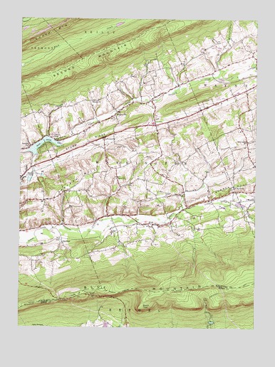
Swatara Hill, PA USGS Topographic Map
Click on map above to begin viewing in our Map Viewer.

This topographic map contains these locations and features:
Feature Name Type Latitude Longitude GNIS ID View Map
Applebee ShelterLocaleN40.5131°W76.3361°1168354View Map
Blue Blazed TrailTrailN40.5076°W76.2752°1169866View Map
Cider Field Airport (historical)AirportN40.6064°W76.2826°2443023View Map
Conrad Weiser BranchStreamN40.5769°W76.3239°2071339View Map
De TurksvillePopulated PlaceN40.5768°W76.3302°1203393View Map
Eagel View Springs Golf CourseLocaleN40.6062°W76.3052°1197042View Map
Eagle View Springs Golf CourseLocaleN40.6068°W76.3052°1213192View Map
Foxs PathTrailN40.5259°W76.2905°1206321View Map
Hauers ChurchChurchN40.5918°W76.3355°1176649View Map
Hertline ShelterLocaleN40.5112°W76.2758°1176905View Map
Hidden Valley Golf CourseLocaleN40.5840°W76.3636°1205811View Map
Iron Ore RunStreamN40.5434°W76.2988°1201676View Map
Manbeck CemeteryCemeteryN40.5540°W76.2969°1180262View Map
Paradise ChurchChurchN40.5726°W76.3705°1183278View Map
Pleasant ValleyPopulated PlaceN40.5629°W76.3708°1184063View Map
RockLocaleN40.5420°W76.3044°1185243View Map
RoedersvillePopulated PlaceN40.5862°W76.3247°1204535View Map
Round HeadPopulated PlaceN40.5087°W76.3097°1204551View Map
Saint Marks ChurchChurchN40.5576°W76.2613°1186326View Map
Salem ChurchChurchN40.5612°W76.3227°1186832View Map
Schneck RunStreamN40.5434°W76.3347°1202613View Map
Schweigerts SchoolSchoolN40.5756°W76.2541°1187140View Map
Spruce RunStreamN40.5412°W76.2830°1201677View Map
StanhopePopulated PlaceN40.5348°W76.3519°1204718View Map
State Game Lands Number 160ParkN40.5418°W76.3347°1211829View Map
Stone RidgeRidgeN40.5756°W76.3400°1188733View Map
Summer HillSummitN40.5579°W76.2624°1189019View Map
Swatara HillSummitN40.5606°W76.3411°1189153View Map
Sweet Arrow LakeReservoirN40.5753°W76.3628°1189168View Map
Sweet Arrow Lake DamDamN40.5701°W76.3663°1194906View Map
Township of WashingtonCivilN40.5634°W76.3087°1217022View Map
Upper Little Swatara CreekStreamN40.5756°W76.3486°1190239View Map
Werts PathTrailN40.5276°W76.2819°1206320View Map
Zion ChurchChurchN40.5537°W76.2891°1191994View Map

Note: Coordinates in the location and feature list above are referenced to NAD83 datum.


Copyright (C) 2008-2024 Ryan Niemi / Sunset Dynamics ... All Rights Reserved