TopoQuest Logo
Do you find TopoQuest useful?
Help keep TopoQuest running and adding new maps/features by donating!
Bitcoin:  19c7KJd3qBynnjoSw5npx9KScwjBe4ifkT
Litecoin:  LXs6TkuXGGXo1vDsWCkWVdjQX94eUKd6ui
Home View Maps Find Maps Find Places Resources & Links


Pine Grove, Pennsylvania Topographic Map

USGS Map Title: Pine Grove, PA
USGS Map MRC: 40076E4
DRG (GeoTIFF) Download: o40076e4.tif


Neighboring USGS Topographic Map Quads:


  Valley View, PA  
40076F5
 

  Tremont, PA  
40076F4
 

  Minersville, PA  
40076F3
 

  Tower City, PA  
40076E5
 

  Pine Grove, PA  
40076E4
 

  Swatara Hill, PA  
40076E3
 

  Indiantown Gap, PA  
40076D5
 

  Fredericksburg, PA  
40076D4
 

  Bethel, PA  
40076D3


Map MRC Location:

N41°
W77°
N41°
W76°
H8 H7 H6 H5 H4 H3 H2 H1
G8 G7 G6 G5 G4 G3 G2 G1
F8 F7 F6 F5 F4 F3 F2 F1
E8 E7 E6 E5 E4 E3 E2 E1
D8 D7 D6 D5 D4 D3 D2 D1
C8 C7 C6 C5 C4 C3 C2 C1
B8 B7 B6 B5 B4 B3 B2 B1
A8 A7 A6 A5 A4 A3 A2 A1
N40°
W77°
N40°
W76°

Pine Grove, PA USGS 1:24K Topographic Map Preview:
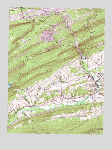
Pine Grove, PA USGS Topographic Map
Click on map above to begin viewing in our Map Viewer.

This topographic map contains these locations and features:
Feature Name Type Latitude Longitude GNIS ID View Map
Adams RunStreamN40.5829°W76.4055°1168064View Map
Baird RunStreamN40.5726°W76.4780°1168587View Map
Bear Hole RunStreamN40.5234°W76.4814°1168879View Map
BeuchlerPopulated PlaceN40.5493°W76.4386°1169444View Map
Black CreekStreamN40.5973°W76.3933°1169693View Map
Black Creek Intake DamDamN40.6056°W76.3755°1194939View Map
Borough of Pine GroveCivilN40.5534°W76.3860°1215563View Map
Brethren ChurchChurchN40.5176°W76.4100°1170208View Map
BrooksidePopulated PlaceN40.5323°W76.3866°1212321View Map
Crowtown SchoolSchoolN40.5340°W76.3866°1172779View Map
DeHaas RunStreamN40.5643°W76.4755°1173012View Map
DoransLocaleN40.6048°W76.4419°1212322View Map
East FranklinPopulated PlaceN40.6212°W76.4305°1197041View Map
Echo ValleyPopulated PlaceN40.6001°W76.3919°1203491View Map
ExmoorPopulated PlaceN40.5334°W76.4119°1203538View Map
Fairview Farm AirfieldAirportN40.5358°W76.4654°2442999View Map
Fishing CreekStreamN40.5512°W76.4936°1174836View Map
Good SpringPopulated PlaceN40.6248°W76.4850°1192524View Map
Good Spring CreekStreamN40.6193°W76.3855°1175805View Map
High Bridge DamDamN40.5451°W76.4964°1194895View Map
Hollernan CemeteryCemeteryN40.5790°W76.3780°1177211View Map
IrvingPopulated PlaceN40.5329°W76.4388°1177867View Map
Jacobs ChurchChurchN40.5359°W76.4158°1177956View Map
Jeffs SwampSwampN40.5668°W76.4719°1202639View Map
JoliettPopulated PlaceN40.6120°W76.4536°1178135View Map
Joliett ChurchChurchN40.6126°W76.4605°1178136View Map
Joliett Volunteer Fire Company District 22 Station 4BuildingN40.6112°W76.4741°2653596View Map
Keffer Fire TowerTowerN40.6087°W76.4619°1213249View Map
KeffersPopulated PlaceN40.6126°W76.4644°1178299View Map
Lebanon ReservoirReservoirN40.5476°W76.4990°1179103View Map
LorberryPopulated PlaceN40.6018°W76.4450°1204063View Map
Lorberry CreekStreamN40.5884°W76.4105°1179948View Map
Lorberry JunctionPopulated PlaceN40.5887°W76.4127°1204064View Map
Lower Little Swatara CreekStreamN40.5370°W76.3888°1180021View Map
Lower Rausch CreekStreamN40.5887°W76.4105°1180030View Map
MarstownPopulated PlaceN40.5398°W76.3780°1180485View Map
Mill CreekStreamN40.5231°W76.4719°1181124View Map
New Saint Nicholas Breaker Pond DamDamN40.5018°W76.4997°1194872View Map
North End Fire Company District 58 Station 2BuildingN40.5574°W76.3922°2652579View Map
Oak Grove Union SchoolSchoolN40.5512°W76.4300°1182757View Map
Oakhill Sediment Pond DamDamN40.5018°W76.4997°1194870View Map
OutwoodPopulated PlaceN40.5443°W76.4761°1183130View Map
Outwood SchoolSchoolN40.5368°W76.4791°1183131View Map
Panther HeadSummitN40.5831°W76.4486°1183251View Map
Panther Valley SchoolSchoolN40.6237°W76.4772°1217456View Map
ParadisePopulated PlaceN40.5690°W76.3811°1183273View Map
Pine GrovePopulated PlaceN40.5484°W76.3847°1183794View Map
Pine Grove Airport (historical)AirportN40.5259°W76.4558°1194012View Map
Pine Grove Area High SchoolSchoolN40.5593°W76.3797°1207300View Map
Pine Grove Area Middle SchoolSchoolN40.5609°W76.3813°1207299View Map
Pine Grove Community AmbulanceBuildingN40.5503°W76.3820°2722310View Map
Pine Grove Elementary SchoolSchoolN40.5470°W76.3866°1207301View Map
Pine Grove Hose Hook and Ladder Fire Company District 58 Station 1BuildingN40.5521°W76.3843°2652654View Map
Pine Grove LandfillLocaleN40.5708°W76.4114°2725970View Map
Pine Grove Police DepartmentBuildingN40.5492°W76.3844°2780102View Map
Pine Grove Post OfficePost OfficeN40.5504°W76.3836°2772912View Map
Pine Grove SchoolSchoolN40.5590°W76.3794°1183819View Map
Rausch CreekPopulated PlaceN40.6120°W76.4263°1205078View Map
RavinePopulated PlaceN40.5745°W76.4038°1184718View Map
Ravine Census Designated PlaceCensusN40.5686°W76.3937°2389729View Map
Ravine Fire Company District 21 Station 1BuildingN40.5749°W76.4021°2652709View Map
Stumps RunStreamN40.5918°W76.4380°1188908View Map
SuedbergPopulated PlaceN40.5270°W76.4697°1188919View Map
Suedberg Community Fire Company District 21 Station 2BuildingN40.5283°W76.4620°2652944View Map
Suedberg Fossil SiteLocaleN40.5195°W76.4763°1207386View Map
Swatara State ParkParkN40.5401°W76.4630°1207387View Map
Swope MountainSummitN40.5173°W76.4455°1189199View Map
Swope Valley RunStreamN40.5365°W76.3952°1189201View Map
Township of Pine GroveCivilN40.5410°W76.4156°1217011View Map
Township of TremontCivilN40.5923°W76.4410°1217018View Map
West Branch Fishing CreekStreamN40.5726°W76.4780°1190904View Map

Note: Coordinates in the location and feature list above are referenced to NAD83 datum.


Copyright (C) 2008-2025 Ryan Niemi / Sunset Dynamics ... All Rights Reserved