TopoQuest Logo
Do you find TopoQuest useful?
Help keep TopoQuest running and adding new maps/features by donating!
Bitcoin:  19c7KJd3qBynnjoSw5npx9KScwjBe4ifkT
Litecoin:  LXs6TkuXGGXo1vDsWCkWVdjQX94eUKd6ui
Home View Maps Find Maps Find Places Resources & Links


Fredonia, Ohio Topographic Map

USGS Map Title: Fredonia, OH
USGS Map MRC: 40082B5
DRG (GeoTIFF) Download: o40082b5.tif


Neighboring USGS Topographic Map Quads:


  Centerburg, OH  
40082C6
 

  Homer, OH  
40082C5
 

  Hunt, OH  
40082C4
 

  Johnstown, OH  
40082B6
 

  Fredonia, OH  
40082B5
 

  Utica, OH  
40082B4
 

  Jersey, OH  
40082A6
 

  Granville, OH  
40082A5
 

  Newark, OH  
40082A4


Map MRC Location:

N41°
W83°
N41°
W82°
H8 H7 H6 H5 H4 H3 H2 H1
G8 G7 G6 G5 G4 G3 G2 G1
F8 F7 F6 F5 F4 F3 F2 F1
E8 E7 E6 E5 E4 E3 E2 E1
D8 D7 D6 D5 D4 D3 D2 D1
C8 C7 C6 C5 C4 C3 C2 C1
B8 B7 B6 B5 B4 B3 B2 B1
A8 A7 A6 A5 A4 A3 A2 A1
N40°
W83°
N40°
W82°

Fredonia, OH USGS 1:24K Topographic Map Preview:
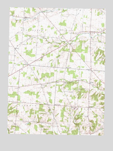
Fredonia, OH USGS Topographic Map
Click on map above to begin viewing in our Map Viewer.

This topographic map contains these locations and features:
Feature Name Type Latitude Longitude GNIS ID View Map
AppletonPopulated PlaceN40.2092°W82.6163°1037457View Map
Appleton CemeteryCemeteryN40.2137°W82.6057°1037458View Map
Barrick CornersPopulated PlaceN40.1909°W82.5507°1037653View Map
Bennington ChapelChurchN40.2398°W82.6060°1070675View Map
Bennington Chapel CemeteryCemeteryN40.2401°W82.6054°1954709View Map
Bowers CemeteryCemeteryN40.1888°W82.5175°1038222View Map
Brooks CornersLocaleN40.1745°W82.5827°1060895View Map
Brushy Fork School (historical)SchoolN40.1265°W82.5179°1052199View Map
Center School (historical)SchoolN40.1562°W82.6124°1052211View Map
Clark CemeteryCemeteryN40.1733°W82.5163°1039136View Map
Cokesbury CornersPopulated PlaceN40.1770°W82.5529°1039235View Map
Curtis School (historical)SchoolN40.1320°W82.6143°1052212View Map
Decrow CornersPopulated PlaceN40.1937°W82.5991°1048653View Map
Devinney School (historical)SchoolN40.1273°W82.5566°1052206View Map
Edelblut CornersLocaleN40.1542°W82.5649°1040069View Map
Fairview School (historical)SchoolN40.2401°W82.6057°1052208View Map
FredoniaPopulated PlaceN40.1520°W82.5199°1040662View Map
Fredonia CemeteryCemeteryN40.1342°W82.5185°1040663View Map
Fredonia Post Office (historical)Post OfficeN40.1528°W82.5193°2026069View Map
Gosnell CornersLocaleN40.1531°W82.5427°1040980View Map
Greenbush School (historical)SchoolN40.1995°W82.5846°1052209View Map
Hancock CemeteryCemeteryN40.1699°W82.6115°1041281View Map
Hancock School (historical)SchoolN40.1715°W82.6113°1052210View Map
High Water Post Office (historical)Post OfficeN40.1765°W82.5193°2026076View Map
HighwaterPopulated PlaceN40.1759°W82.5193°1056330View Map
Highwater OrchardLocaleN40.1728°W82.5400°2515703View Map
Highwater United Church of ChristChurchN40.1765°W82.5216°1071328View Map
Hillcrest Airport (historical)AirportN40.1609°W82.6243°1082760View Map
Jones School (historical)SchoolN40.1484°W82.5432°1052205View Map
Lafayette School (historical)SchoolN40.2042°W82.5482°1052203View Map
Liberty CemeteryCemeteryN40.1770°W82.5632°1954719View Map
Liberty ChurchChurchN40.1770°W82.5627°1070816View Map
McKean SchoolSchoolN40.1437°W82.5207°1043114View Map
Moorehead CemeteryCemeteryN40.1328°W82.5810°1043473View Map
Morgan School (historical)SchoolN40.1309°W82.5813°1052207View Map
New WayPopulated PlaceN40.1542°W82.5735°1065140View Map
New-way Post Office (historical)Post OfficeN40.1542°W82.5729°2026083View Map
Northridge High SchoolSchoolN40.1884°W82.6071°1052270View Map
Old Fredonia CemeteryCemeteryN40.1520°W82.5221°1954721View Map
Patterson CemeteryCemeteryN40.2184°W82.5438°1954722View Map
Pattersons CornersLocaleN40.2173°W82.5496°1044322View Map
Pattons CornersPopulated PlaceN40.2270°W82.5196°1063394View Map
Pleasantville School (historical)SchoolN40.1753°W82.5782°1052204View Map
Reynolds CreekStreamN40.2153°W82.5696°1065879View Map
Runaway School (historical)SchoolN40.2365°W82.5710°1052202View Map
Six CornersLocaleN40.1901°W82.5177°1046307View Map
Sugar CreekStreamN40.2153°W82.5479°1046802View Map
Township of BenningtonCivilN40.2324°W82.6068°1086452View Map
Township of BurlingtonCivilN40.2266°W82.5132°1086454View Map
Township of LibertyCivilN40.1567°W82.6126°1086466View Map
Township of McKeanCivilN40.1520°W82.5175°1086469View Map
Union School (historical)SchoolN40.2181°W82.5191°1052200View Map
Wright School (historical)SchoolN40.2490°W82.5346°1052201View Map

Note: Coordinates in the location and feature list above are referenced to NAD83 datum.


Copyright (C) 2008-2024 Ryan Niemi / Sunset Dynamics ... All Rights Reserved