TopoQuest Logo
Do you find TopoQuest useful?
Help keep TopoQuest running and adding new maps/features by donating!
Bitcoin:  19c7KJd3qBynnjoSw5npx9KScwjBe4ifkT
Litecoin:  LXs6TkuXGGXo1vDsWCkWVdjQX94eUKd6ui
Home View Maps Find Maps Find Places Resources & Links


West Helena, Arkansas Topographic Map

USGS Map Title: West Helena, AR
USGS Map MRC: 34090E6
DRG (GeoTIFF) Download: o34090e6.tif


Neighboring USGS Topographic Map Quads:


  Rondo, AR  
34090F7
 

  La Grange, AR  
34090F6
 

  Stubbs Island, MS  
34090F5
 

  Lexa, AR  
34090E7
 

  West Helena, AR  
34090E6
 

  Helena, AR  
34090E5
 

  Lakeview, AR  
34090D7
 

  Friars Point NW, MS  
34090D6
 

  Moon Lake, MS  
34090D5


Map MRC Location:

N35°
W91°
N35°
W90°
H8 H7 H6 H5 H4 H3 H2 H1
G8 G7 G6 G5 G4 G3 G2 G1
F8 F7 F6 F5 F4 F3 F2 F1
E8 E7 E6 E5 E4 E3 E2 E1
D8 D7 D6 D5 D4 D3 D2 D1
C8 C7 C6 C5 C4 C3 C2 C1
B8 B7 B6 B5 B4 B3 B2 B1
A8 A7 A6 A5 A4 A3 A2 A1
N34°
W91°
N34°
W90°

West Helena, AR USGS 1:24K Topographic Map Preview:
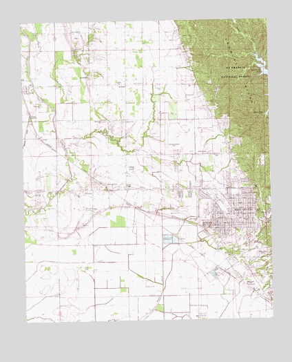
West Helena, AR USGS Topographic Map
Click on map above to begin viewing in our Map Viewer.

This topographic map contains these locations and features:
Feature Name Type Latitude Longitude GNIS ID View Map
Antioch ChurchChurchN34.5657°W90.6723°65534View Map
Beech Crest Elementary SchoolSchoolN34.5449°W90.6328°83564View Map
Belser (historical)Populated PlaceN34.5470°W90.6940°65536View Map
Billingsley CemeteryCemeteryN34.6023°W90.7157°65537View Map
Busby CemeteryCemeteryN34.5987°W90.7018°47226View Map
Caney CreekStreamN34.5307°W90.6807°47426View Map
Central High SchoolSchoolN34.5449°W90.6257°77158View Map
Church of GodChurchN34.5473°W90.6434°65523View Map
Church of God of ProphecyChurchN34.5462°W90.6346°65503View Map
Crooked CreekStreamN34.5723°W90.7287°48171View Map
DeSoto Elementary SchoolSchoolN34.5607°W90.6393°65529View Map
DeSoto High SchoolSchoolN34.5612°W90.6393°65530View Map
East ParkParkN34.5551°W90.6343°65528View Map
Faith Outreach MinistriesChurchN34.5579°W90.6446°65522View Map
First Assembly of God ChurchChurchN34.5479°W90.6407°65504View Map
Fourth Saint ChurchChurchN34.5734°W90.6468°49205View Map
Freederia School (historical)SchoolN34.5104°W90.6321°70113View Map
Freedonia ChurchChurchN34.5143°W90.6387°76974View Map
Helena Country ClubLocaleN34.5309°W90.6321°65509View Map
Helena Hospital HeliportAirportN34.5098°W90.6262°83722View Map
Helena JunctionLocaleN34.5873°W90.7465°65538View Map
Helena Regional Medical CenterHospitalN34.5099°W90.6270°65510View Map
HumaPopulated PlaceN34.5348°W90.6732°57957View Map
Jackson ChapelChurchN34.5832°W90.6987°50561View Map
Jackson Chapel CemeteryCemeteryN34.5831°W90.6982°81654View Map
KCLT-FM (West Helena)TowerN34.5157°W90.6704°85251View Map
KCRI-FM (Helena)TowerN34.5276°W90.6296°85192View Map
KFFA-AM (Helena)TowerN34.5276°W90.6301°85087View Map
KJIW-AM (West Helena)TowerN34.5145°W90.6384°85150View Map
KJIW-FM (Helena)TowerN34.5145°W90.6384°85191View Map
LatourPopulated PlaceN34.5762°W90.7412°77453View Map
Lexa Post OfficePost OfficeN34.5992°W90.7497°2781879View Map
Miller Junior High SchoolSchoolN34.5564°W90.6603°65527View Map
Mount Olive ChurchChurchN34.5965°W90.6801°52350View Map
Mount Pleasant CemeteryCemeteryN34.6184°W90.7226°81659View Map
Mount Pleasant ChurchChurchN34.6204°W90.7240°52402View Map
New Zion CemeteryCemeteryN34.5443°W90.6754°81662View Map
New Zion ChurchChurchN34.5445°W90.6754°77842View Map
New Zion School (historical)SchoolN34.5437°W90.6779°70127View Map
O'Shield CemeteryCemeteryN34.5701°W90.6618°65532View Map
Oak Grove Garden CemeteryCemeteryN34.5401°W90.6615°77874View Map
Odd Fellows CemeteryCemeteryN34.5412°W90.6620°77895View Map
Pafford Emergency Medical Services West HelenaBuildingN34.5179°W90.6339°2119062View Map
Pettis Memorial ChurchChurchN34.5445°W90.6537°65525View Map
PillarPopulated PlaceN34.5462°W90.7159°78001View Map
Pillar School (historical)SchoolN34.5215°W90.7329°81663View Map
Pleasant Hill ChurchChurchN34.6132°W90.7232°53571View Map
Pleasant Joy ChurchChurchN34.5145°W90.6896°53583View Map
Pleasant Joy School (historical)SchoolN34.5170°W90.6801°70129View Map
Polly Dots CemeteryCemeteryN34.5276°W90.6465°53668View Map
Rindy Grove CemeteryCemeteryN34.5909°W90.7409°81664View Map
Rindy Grove CemeteryCemeteryN34.5918°W90.7418°54043View Map
Rollingwall SchoolSchoolN34.5993°W90.6973°81893View Map
Saint Marks CemeteryCemeteryN34.5762°W90.6451°65531View Map
Saint Marks Church (historical)ChurchN34.5751°W90.6465°81666View Map
Saint Matthews ChurchChurchN34.5315°W90.6532°81895View Map
Saint Pauls CemeteryCemeteryN34.5409°W90.7207°81667View Map
Saint Pauls ChurchChurchN34.5404°W90.7207°54456View Map
SouthlandPopulated PlaceN34.5854°W90.6540°58662View Map
Spring Lake CemeteryCemeteryN34.5834°W90.7095°55117View Map
Spring Lake ChurchChurchN34.5918°W90.6973°55118View Map
Spring Lake Church (historical)ChurchN34.5837°W90.7090°81670View Map
Stephens CemeteryCemeteryN34.5126°W90.6343°55204View Map
Thompson-Robbins AirportAirportN34.5711°W90.6719°83721View Map
Township of CleburneCivilN34.6122°W90.6964°68946View Map
Township of HornorCivilN34.5400°W90.6791°68951View Map
Walters Southland InstituteSchoolN34.5990°W90.6868°81671View Map
Watson Temple ChurchChurchN34.5987°W90.6871°65533View Map
West HelenaPopulated PlaceN34.5507°W90.6418°58852View Map
West Helena Baptist ChurchChurchN34.5443°W90.6371°65506View Map
West Helena Church of the NazareneChurchN34.5401°W90.6376°65508View Map
West Helena City HallBuildingN34.5443°W90.6457°65524View Map
West Helena Fire DepartmentBuildingN34.5443°W90.6457°2117296View Map
West Helena Police DepartmentBuildingN34.5443°W90.6457°2118604View Map
West Helena Post OfficePost OfficeN34.5432°W90.6423°84330View Map
West Helena Public LibraryBuildingN34.5437°W90.6376°65507View Map
West Helena United Methodist ChurchChurchN34.5443°W90.6393°65505View Map
West ParkParkN34.5376°W90.6565°65526View Map
West Side Elementary SchoolSchoolN34.5388°W90.6512°83566View Map
Woodruff Elementary SchoolSchoolN34.5414°W90.6361°83565View Map
WycampPopulated PlaceN34.5548°W90.7157°78813View Map
Wycamp Missionary ChurchChurchN34.5562°W90.7054°65535View Map

Note: Coordinates in the location and feature list above are referenced to NAD83 datum.


Copyright (C) 2008-2024 Ryan Niemi / Sunset Dynamics ... All Rights Reserved